Category Geography

Why Assam is called Land of Red River and Blue Hills?

Assam is one of the Eight Sister States of North A eastern India. Known for its rich culture and diverse population, the culture of Assam is a fusion of Indo-Burmese, Mongolian and Aryan influence. It is bounded to the north by the kingdom of Bhutan and Arunachal Pradesh, to the east by Nagaland and Manipur, to the south by Mizoram and Tripura, and to the west by Bangladesh and the States of Meghalaya and West Bengal

The name Assam is derived from the word asama meaning “peerless” in the now extinct Ahom language. The neighbouring states of Arunachal Pradesh, Nagaland, Mizoram, and Meghalaya were once part of Assam. The capital, formerly Shillong (now the capital of Meghalaya), was shifted to Dispur, a suburb of Guwahati, in 1972. The beautiful land, known as the land of red rivers and blue hills’ is a little paradise with untouched natural landscapes worth traversing for its pristine beauty

Major tribes of Assam

Ahom or Tai-Ahom: They are the admixed descendants of the Tai people who reached the Brahmaputra Valley of Assam in 1228.

Karbis: They are one of the major ethnic communities in Assam and especially in the hill areas of Assam.

Bodo-Kacharis (also Kacharis or Bodos) are an anthropological and a linguistic group living predominantly in Assam, Tripura and Meghalaya.

Mising is an indigenous community inhabiting parts of Assam and Arunachal Pradesh.

Nyishi community is the largest ethnic group and they live in the Sonitpur and North Lakhimpur districts of Assam.

Rabha live mostly in Goalpara, Kamrup, Kokrajhar, Udalguri, and Baksa districts; and also in some places Bongaigaon, Chirang, Sonitpur, and Karbi Anglong districts.

Rajbongshi or Koch-Rajbongshi is an ethnic group inhabiting parts of Assam, Meghalaya, and northern West Bengal.

Tea-garden community composed of multi-ethnic groups of tea garden workers and their dependants in Assam. They are officially referred as “Tea tribes” by the Government of Assam. They are the descendants of indigenous people brought by the British colonial planters as labourers from the regions of present-day Jharkhand, Odisha, Chhattisgarh, West Bengal and Andhra Pradesh into colonial Assam during 1860-90s in multiple phases for the purpose of being employed in the tea garden industry as labourers.

Customs and traditions

Customs and traditions play a significant role in society and the Assamese strictly adhere to the customs laid down by their forefathers, pertaining to their communities. These customs are beliefs that originated in the past and have been followed ever since, generation after generation Weddings, births, deaths and festivals in Assam include many customs that are supposed to be followed by all.

The people of Assam always believed in the joint family system and it is still prevalent among both tribal and non-tribal communities. Some of the tribes follow the matriarchal system, which asserts that the mother is the centre of the clan and that her property will be given to her daughters. If there are no daughters, it will be passed to the youngest daughter of her sister. The prevalent custom among the Dimasa-Kacharis is that the sons inherit the father’s property while the daughters inherit the mother’s property. The Assamese use bamboo to welcome guests because of their attachment to the bamboo culture.

Traditional dress

The Assamese adorn very simple dresses, mostly hand loomed. Women wear the motif-rich Mekhela Chador or Riha-Mekhela, while men wear the ‘suria’ or ‘dhoti’, and over it drape a chadar known as ‘Seleng’. Gamosa is an indispensable part of almost all socio-religious ceremonies in Assam. It is derived from the Kamrupi word ‘Gaamasa’ (gaama + chadar) which was used to cover the Bhagavad Purana at the altar. It is a white rectangular piece of cloth with a red border on three sides and woven motifs on the fourth. Bihu dancers wrap it around the head, and it is still used to cover the altar at the prayer hall or the scriptures.

Jaapi: This is basically known as the sunshade of Assam. It is made of bamboo strips and dried palm leaves locally known as Tokow Pat. There are many types of Jaapi like the Halua Jaapi, Pitha Jaapi, Sorudoiya Jaapi, Bordoiya Jaapi, etc. Jaapis were also used as headwear in the olden days, mostly by the rich Folk music instrument and noble families. Farmers use Jaapi as umbrellas while working in the paddy fields.

Folk music

Assam is rich in folk music. From the time of the Kamarupa Kingdom followed by Ahom Dynasty, Assamese culture has been influenced by their rulers, except for the British rule which ended the Ahom Dynasty. The indigenous folk music has influenced the folk music of artistes like Bhupen Hazarika, Parvati Prasad Baruva, Jayanta Hazarika, Utpalendu Choudhury, Nirmalendu Choudhury and others. Classical Assamese music is divided into Borgeet and Ojapali which combines narrative singing with dancing. The music of Oja-pali has a raga system of clear traditional orientation.

Arts and craft

Traditional crafts like pottery and terracotta work, brass craft, jewellery-making, musical instruments making, cane and bamboo craft, silk and cotton weaving and woodcraft are a major source of employment for the people of Assam.

Weaving is the most ancient among these, and even now women take pride in working in the handloom industry. Gandhiji lauded the Assamese weavers as artistes who could weave dreams in their looms. Various ethno cultural groups make exclusive types of cotton garments with embroidery designs and colour combinations

Painting is another ancient form of art known since the time of Chinese traveller Xuanzang (7 century CE). Most of the manuscripts from the middle ages have excellent examples of traditional paintings. They were influenced by the concept and designs in the medieval works such as the Chitra Bhagavata. There is a Department of Fine Arts in Assam, which is a central government organization that focuses on the art and craft of north east India with particular reference to Assam.

Festivals

Assam is full of festivals, the most important being the Bihu. It is celebrated to mark the important points of a cultivator’s life over a yearly cycle. It is a non-religious festival celebrated by all irrespective of caste and creed. Rongali or Bohag Bihu celebrated in mid-April with the coming of spring and the beginning of the sowing season. It is also known as Rangaali Bihu (‘rang means ‘merry-making’).

Another important festival is the Kangaali Bihu (‘kangaali’ meaning ‘poor’) is celebrated in mid-October. It is called so because by this time the harvest is brought home. The Magh Bihu is celebrated in mid-January. There are community feasts and bonfires which take place during the festival days. Also known as the Bhogaali Bihu (‘bhog’ means ‘enjoyment and feasting’). The first day of rongali bihu is called Goru Bihu when the cows are taken to the nearby ponds to be bathed. Ali-Ai-Ligang is the spring festival, and the name of the festival is made up of three terms — ‘Ali’, root and seed, ‘Ai’ means fruit and ‘Ligang, to sow.

Traditional dances

Ojapali, Devdasi, and Sattriya are the major dance styles of Assam. Oja, the lead dancer, narrates a mythological story along with the fusion of dance and acting. It is of three types – biyah-gowa that presents Mahabharata stories with the rhythmic use of feet, sukananni which celebrates the worship of snake goddess Manasa, and ramayani based on the Assamese version of Ramayana. Sattriya was developed by Sankardeva.

Devadasi-deva-nati or nati nas is a conventional temple dance that is performed by unmarried women who submitted their lives to the presiding deity. The dances of the Bodos are associated with the Kherai Puja festival where Bagurumba dance is the most popular. Other folk dances are incomplete without the Jhumur performed by the Adivasis which is a synchronized dance of boys and girls to the sound of drums and flute.

Cuisine

Assamese dishes are said to be less spicy than any other Indian dishes. Assamese are mostly non-vegetarian, and their staple diet is rice. Fish, chicken, duck and pork are also eaten and are popular. Fish curry is prepared as a sour dish called Machor tenga. Baked fish wrapped in leaves with white mustard paste is a popular delicacy. Dried fish is a traditional tribal cuisine. The variance of rice are produced and prepared like Cheera (flattened rice), akhoi (parched paddy grain), muri (puffed rice), pithguri (pound rice), sandoh guri (fried, pound rice), komal saul and bora saul. The presence of traditional “detoxifying’ appetizers like Khar is prepared by burning the stem of the banana tree.

People who have a weakness for sweets won’t be disheartened one bit as the Assamese dish is incomplete without sweets and one of its specialties called pitha is made from rice. Til pitha (moulded sticky rice cake with black sesame filling), ghila pitha (fried rice cakes), sunga pitha (rice cake baked inside whole bamboo pieces), narikolor laaru (sweet coconut balls) and kol pitha (banana pancakes) are some of the other delicacies of the Assamese cuisine.

Traditional jewellery

Assamese jewellery is usually handmade, and the designs depict flora and fauna. The people are fond of wearing beautiful and unique style of ornaments made of gold and silver and varieties of jewels. The traditional ones worn by men are called Biri, Magardana, Matamoni, Kundal and Lokaparo while those worn by the women are Keru, Karphul, Kharu, Aargathi, Nalak, Keyur and Nupur.

Major occupations

Agriculture is the main occupation of the people in Assam. It accounts for 63 per cent of the state’s workforce. Most farmers are engaged in the cultivation of rice, which is the staple diet of the people. Other crops include pulses, jute, tea and fruit cultivation. Assam is well-known all over the world for its tea plantations and the tea gardens of Assam provide employment to nearly a million people. Assam’s tea plantation forms 15 per cent of the world’s tea output.


Picture Credit : Google

Kashmir saffron gets Geographical Indication tag

Kashmiri saffron has a Geographical Indication tag marking its ingenuity and making it illegal for anyone outside the valley to sell a similar product under the “Kashmiri saffron” name. Jammu & Kashmir is the only state in India that produces saffron, also known as ‘red gold’. Pampore is known as the ‘saffron bowl’; the town’s saffron is considered to be of superior quality because of the high concentration of crocin (8.72%) – which gives the saffron its darker colour and medicinal value – as compared to the Iranian variety (6.82%).

The saffron available in Kashmir is of three types — ‘Lachha Saffron’, with stigmas just separated from the flowers and dried without further processing; ‘Mongra Saffron’, in which stigmas are detached from the flower, dried in the sun and processed traditionally; and ‘Guchhi Saffron’, which is the same as Lachha, except that the latter’s dried stigmas are packed loosely in air-tight containers while the former has stigmas joined together in a bundle tied with a cloth thread.

Saffron cultivation is believed to have been introduced in Kashmir by Central Asian immigrants around 1st Century BCE. In ancient Sanskrit literature, saffron is referred to as ‘bahukam’.


Picture Credit : Google

Which village is known as ‘Aloe Vera village in Ranchi?

Dewri village in Ranchi is known as ‘Aloe Vera village’ after the Indian Council of Agricultural Research (ICAR) and Birsa Agricultural University (BAU) motivated villagers to take up aloe vera plantation to boost their income. Aloe vera takes 18 months to grow fully and the first lot of leaves were sold profitably as aloe vera is in high demand for its medicinal and cosmetic properties. The villagers saw their income increase from Rs 3,000 per month from paddy cultivation to s 5,000-6,000 per month.

Villagers are happy with the increase in their income.

“Earlier, we used to earn around Rs 3,000 per month from paddy cultivation if we were able to get work for all the 30 days. However, this year, apart from working in paddy fields, we were able to boost our income by selling aloe vera leaves. Our income has increased between Rs 5,000 and 6,000 per month,” said Manju Kachyap, mukhiya of the Dewri village and a woman farmer.

Manju said out of the 90 families belonging to the Oraon tribe residing in their village, nearly 40 families had taken part in planting aloe vera.


Picture Credit : Google

What language does not have numbers?

The Piraha tribe in the Amazon region of Brazil does not have words for specific numbers nor do they count. The Piraha language contains just three words for quantities: Hoi for “small size or amount”, hoi for “somewhat larger amount”, and baagiso for “many”. Linguists refer to languages that do not have number-specific words as anumeric.

There’s still much to learn about this niche language. Although the 2016 MIT study was the most extensive to date on Piraha, analyzing 1,100 translated sentences, deeper research is required to say with certainty that recursion doesn’t exist.

The strongest statement researchers could make: “It’s plausible.”

Although Daniel Everett has studied Piraha longer than any other known researcher, his findings are often called into question. He has suggested the tribe does not have words to describe colors, for example, and that idea has also been challenged. Other researchers have started to study Piraha, but there’s little agreement thus far on much of anything.

Despite the uncertainty, Piraha serves as a fascinating reminder that perhaps we haven’t unraveled the mystery that is human language. With such a small Piraha population remaining, linguists and translators face a race against time to learn everything they can about one of the world’s most isolated languages before it disappears entirely.


Picture Credit : Google

Why is China’s new dam a cause for concern?

What is the course of the river Brahmaputra?

The Brahmaputra (called Yarlung Tsangpo in China) is one of the longest rivers in the world. Starting in the Himalayas in Tibet it enters India in Arunachal Pradesh, then passes through Assam, Bangladesh, and empties into the Bay of Bengal. The Brahmaputra, a perennial river, is the lifeline for communities living along its banks. They use it for irrigation, fisheries and inland water transport, In its lower course, the river is both an advantage and a disadvantage. On the one hand, it deposits huge quantities of fertile alluvial soil suitable for agriculture, but on the other, due to geographical and climatic conditions, it causes periodical disastrous floods in Assam and Bangladesh.

Where is China planning to build the dam?

The dam is to be built on the river in Medog county, where it drops by 2,000 metres, making it an ideal place to harness hydropower. This region is located in the Tibet Autonomous Region, governed by China.

Why is China building it?

The proposal to build a dam on Yarlung Tsangpo featured in China’s 14th Five Year Plan announced in 2020. According to the Chinese officials, the hydroelectric project in the Medog county is part of the country’s renewable energy generation initiatives and that it will help China achieve carbon neutrality by 2060 and also pave way for development in the Tibet Autonomous Region.

In 2010, China began construction of small dams along the mainstream of the Yarlung Tsangpo, two of them have already been completed and at least three are under construction, according to reports. The proposed one is the largest of them all.

How big is this project?

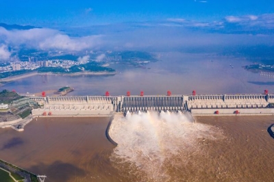
The new dam could help generate up to 60 gigawatts of power three times that of central China’s Three Gorges Dam, which has the largest installed hydropower capacity in the world now. The new dam could provide 300 billion kWh of dean, renewable and zero carbon electricity annually. The power generated would help Beijing meet its clean energy goals and strengthen water security, according to Yan Zhiyong, chairman of the Power Construction Corporation of China.

What will be its impact on India?

Agriculture

Such a huge dam could hold back massive amount of silt carried by the river (silty soil is more fertile than other types of soil and it is good for growing crops.) This could affect farming in the areas downstream.

Water resources

The construction of dams upstream will have a significant effect on areas downstream. China has claimed that it is building a run of the river hydropower project, which do not involve storage or diversion of the waters of the Brahmaputra (Run of the river hydroelectric systems are hydroelectric systems that harvest the energy from flowing water to generate electricity). However, experts say it could still reduce water flow downstream, especially during the dry season.

India is also worried about the release of water during the monsoons, when northeastern states such as Assam experience floods. If China released water from the dam, it could be disastrous for an already inundated Assam.

Water as a weapon?

Being an upstream area, China has a dear advantage in building dams and other infrastructure to store or divert the flow of the river system

There is the potential to significantly change the flow rate during times of standoff between the countries. India has agreements with China that require the latter to share hydrological data of the river during monsoon season between May and October. The data is mainly of the water level of the river to alert downstream areas in the event of floods. However, during the 2017 Doklam border standoff between India and China, China stopped communication of water flow levels from its dams. Though data sharing resumed in 2018, India has reasons to believe that China may withhold data.

Seismological impact

The Himalayan region is vulnerable to earthquakes and other seismic activities. The sheer size of the infrastructure projects undertaken there poses a significant threat to the populations living downstream

Ecological impact

Several species of flora and fauna are endemic to this part of the world and some of them are critically endangered. The ecosystem in the Himalayan region is already on the decline. The glaciers have been retreating due to climate change. Deforestation soil erosion and landslides are some of the other issues here. The combined dam plans of China and India (See net question) could have disastrous consequences in this ecologically sensitive zone.

What is India’s response?

India has urged China to ensure that the interests of downstream states are not harmed by any activity in upstream areas. Meanwhile, India is considering building a 10 gigawatts (GW) hydropower project in the Dibang valley in Arunachal Pradesh, to mitigate the adverse impact of the Chinese dam.


Picture Credit : Google

What is Rann of Kutch famous for?

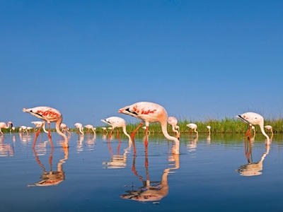
The Wild Ass Sanctuary spans nearly 5,000 sq km. in Gujarat’s Little Rann of Kutch. Home to the third largest population of these animals in the world, the area is believed to be nurturing at least a few thousands of these mammals. Usually moving in large groups, these animals can be spotted throughout the year in this region. Due to its proximity to the Rann of Kutch and the variety in the region’s vegetation, the sanctuary hosts more than 30 species of rare and endangered animals, and over 90 species of invertebrates. In fact, the sanctuary also lies on the migratory route of several hundred birds that travel from as far as Europe, Russia and Egypt.

Wildlife

More than 350 species of birds can be spotted in the region, and these include ducks, geese, quails francolins, flamingoes, grebes, doves, pigeons, sandgrouses, nightjars, swifts, coucals, malkohas, cuckoos, koels, crakes, cranes, bustards, storks, pelicans, herons, egrets, ibises, cormorants, thick knees, plovers, lapwings, godwits, sandpipers, pratincoles, gulls, terns, kites, eagles, buzzards, vultures, owls, woodpeckers, bee-eaters, rollers, kingfishers, falcons, parakeets, orioles, drongos, shrikes, flowerpeckers, sunbirds, weavers, pipits, wagtails, buntings, larks, prinias, warblers, swallows, martins, bulbuls, starlings, flycatchers and wheatears. In addition to the wild ass, the place hosts several other animals, including chinkara, nilgai or blue bull, black buck, wild boar, Indian wolf, jackal, striped hyna, desert hare, desert cat, pangolin, porcupine, Indian fox, mongoose, and jungle cat.

There’s good news…

In 2015, the census of the wild ass showed that the total number of these ungulates was a little short of 4.500. A similar exercise conducted in March 2020 showed that the Umber stood at a little over 6,000 – showing a spike of 30 % in just five years. This is particularly encouraging, considering the species had a worrying history. Due to the outbreak of diseases, the number of these mammals had fallen to a mere 700 back in the 1960s. The population today points to a successful and concerted conservation effort over decades. It also points to the need to be mindful of the continuing threats faced by the wild ass, found in the wild only in this part of the country.

… but threats persist

While a growing population is comforting to hear, the threats that these animals face remain a concern. Since the paths of these animals cross those of domestic livestock that herders take out for grazing, the chance of a disease outbreak and the animals contracting it are high. Further, water carrying pesticide and fertilizer from farmlands outside the sanctuary enter the region, with potential to harm animals that could drink the polluted water. The increasing number of salt pans and illegal mining in the region are additional threats to the sanctuary.


Picture Credit : Google

What is the polar vortex?

Scientists have wanted that a weather phenomenon called the polar vortex could bring frigid temperatures and stormy weather to the Northern Hemisphere this year too. The phenomenon is a fairly Common occurrence and meteorologists keep a dose watch on the stratosphere for signals on potential Arctic air invasions and predict their severity,

The polar vortex is a large area of low pressure that consistently overlies the North and the South poles. They are called vortexes because of the mass of cold, dense air that spins counter clockwise like a hurricane. Sometimes during winter in the Northern Hemisphere, this vortex becomes weak and expands, sending the Arctic cold air southward into the United States, Europe and Asia. Ironically, the cause of this chill is a sudden heat seeping into the whirling currents. That is, the temperature surge in the stratosphere, the layer of the atmosphere, which is located between 10 and 50 km above the ground leads to the weakening of the polar vortex. And it wobbles off the pole.

The polar vortex is capable of delivering subzero temperatures for several days together In the recent past, the 2014 polar vortex is remembered as it gave rise to record low temperatures which lasted until March.

Some scientists suggest that warming in the Arctic and climate change could make the polar vortex unstable in the coming years, leading to potentially serious consequences.


Picture Credit : Google

What type of structure is the Burj Khalifa?

There are few buildings in the world that share the kind of popularity that the Burj Khalifa enjoys. A towering skyscraper in Dubai, United Arab Emirates, the Burj Khalifa’s total height is 829.8 m and its roof height (excluding antenna) is 828 m. That makes it the tallest structure and building in the world, since its official launch ceremony in January 2010.

The spider lily

Such a massive structure is naturally an engineering Marvel. What makes it even more special is its design. The Burj Khalifa has a triple-lobed footprint, an abstraction of the Hymenocallis flower. The Hymenocallis or spider lily is a regional desert flower from which the architects drew inspiration for the iconic tower’s design. While this beautiful choice maximises window viewing, the architects didn’t go for it purely for Aesthetic or ornamental reasons. This design ensures that the tower is composed of different features that are arranged around a central core. This provides for an inherently stable configuration, vital for super-tall buildings.

Biomimetics

The modular, Y-shaped structure has setbacks along each of its three wings and affords lateral bending resistance. The central core, which emerges on top and culminates in a sculpted spire, provides strong torsional resistance.

The Burj Khalifa thus serves as a great illustration of biomimetics or biomimicry – the science or art of emulating systems and elements of nature in order to solve complex human problems.


Picture Credit : Google

Why Periyar Tiger Reserve is famous?

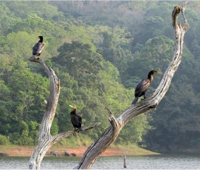
Spanning over 725 sq. km., the Periyar Tiger Reserve in Kerala is one of the rich biodiversity hotspots of the Western Ghats. Comprising a range of tropical evergreen and semi-evergreen forests, moist deciduous forests, grasslands and eucalyptus plantations, it is amply nourished by rivers such as the Periyar running through the region. The reserve is a green zone that’s home to more than a 100 varieties each of grasses and orchids – perfect to welcome several species of mammals, reptiles, amphibians, birds and butterflies. The region also hosts a large number of Asiatic elephants, making it one of the most significant elephant reserves of the country.

Wildlife

Garganeys, little grebes, nightjars, swift, coucal, malkohas, crakes, bitterns, cormorants, snipes, sandpipers, harriers, hornbills, woodpeckers, barbets, bee-eaters, falcons, minivets, orioles, woodshrikes, shrikes, treepies, flowerpeckers, sunbirds, leaf birds, munias, pipits, wagtails, tits, larks, prinias, warblers, swallows, babblers, starlings, nuthatches, flycatchers, robins and thrushes are among the species of birds that can be seen here. In addition to the Royal Bengal tiger and the Asiatic elephant, one can spot mammals such as leopard, bison, sambar, barking deer, Indian wild dog, wild boar, Nilgiri marten, Nilgiri langur and otter. A variety of reptiles such as cobra, viper, krait, and Indian monitor lizard, and amphibians such as frogs and toads too are found in the region.

Cause for concern

report by the Comptroller and Auditor General of India in 2019 A said that the Travancore Devaswom Board (TDB), an autonomous body that manages 1,248 temples including the Sabarimala Ayappa Temple, has been violating the Master Plan for Sabarimala for over a decade. This is affecting the ecology of the Periyar Tiger Reserve”. The report on the implementation of Wildlife Protection Act in Kerala says that the “impact of Sabarimala pilgrimage ranked first in the list of 18 major threats identified by Periyar Tiger Reserve authorities in Tiger Conservation Plan”. It added that due to the lack of drainage facilities, overflowing waste water and sewage was mixing with the rivers in the region. Further, electric lines had not been laid underground, and the existing “overhead cables without insulation” could pose a threat to wildlife species in the area.

Poachers to protectors

The Periyar Tiger Reserve is an example of an unusual success story. According to Mongabay, a conservation and environment news and features service, the story begins towards the end of the 20th Century, when a forest brigand operating near the reserve is captured. He led a 23-member gang of poachers and sandalwood smugglers. And was willing to give it all up if they were assured of a job with a steady income. However, back then there was no provision to include poachers and smugglers in forest management. Several discussions happened and a few years passed before Vidiyal Vanapathukappu Sangam was set up. It would be the country’s first eco-development committee constituted solely of former poachers and sandalwood smugglers””. The group underwent training and was exposed to the need for conservation. It’s been 17 years since. The members have helped crack at least “230 cases of poaching and smuggling”. In addition to patrolling, they also double up as tourist guides and elephant safari providers. Most importantly, they have managed to educate their children – some are postgraduates today! The success of this model has been so encouraging that several other reserves and sanctuaries too have emulated it.


Picture Credit : Google

What is the rarest naturally occurring element in Earth’s crust?

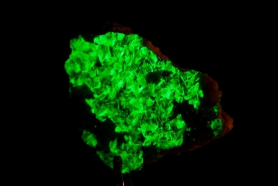
Astatine is the rarest, naturally occurring element in the Earth’s crust, occurring only as the decay product of various heavier elements. There are only about 25 grams of naturally-occurring astatine in Earth’s crust at any given time. It is a radioactive chemical element with symbol At and atomic number 85. It is the heaviest known halogen (a non-metal), but it has more metallic character than other elements in the halogen group.

The bulk properties of astatine are not known with certainty. Many of them have been estimated based on the element’s position on the periodic table as a heavier analog of iodine, and a member of the halogens (the group of elements including fluorine, chlorine, bromine, and iodine). Astatine is likely to have a dark or lustrous appearance and may be a semiconductor or possibly a metal; it probably has a higher melting point than that of iodine. Chemically, several anionic species of astatine are known and most of its compounds resemble those of iodine. It also shows some metallic behavior, including being able to form a stable monatomic cation in aqueous solution (unlike the lighter halogens).


Picture Credit : Google