Category Information Technology

What do driverless cars use to determine the best route or course of action when travelling from one location to the next?

From finding the fastest path to a cafe to self-driving cars, modern necessities and benefits rely upon something that many take for granted: the Global Positioning System (GPS). GPS is so deeply ingrained into our daily lives that it’s difficult to picture a world without it, but did you know where it came from?

The origin of GPS

In the middle of the 1960s, the US Navy experimented with satellite navigation to follow U.S. submarines that were carrying nuclear weapons. The Department of Defence (DOD) decided to employ satellites to support their scheduled navigation system in the early 1970s because they wanted to make sure that it was a reliable, stable system, based on previous ideas from navy scientists. In 1978, the Department of Defence launched the first Navigation System with Timing and Ranging (NAVSTAR) satellite which later changed into GPS. In 1993, the 24-satellite constellation went into full functioning. It was initially intended to replace earlier navigation systems and locate military transportation equipment worldwide with accuracy. Over time, the GPS evolved into an easily available, free device that improves daily safety and comfort together

The Pioneers behind GPS

Despite being created by the U.S. Department of Defence, a few scientists have been recognized as having made significant contributions to this ground-breaking technology. Roger L. Easton led the Space Application division of the Naval Research Laboratory. Timing technology and circular orbits are two of the most important aspects of GPS that he specialised in as a Cold War scientist. As the first manager of the Navstar GPS programme, Brad Parkinson contributed to the program’s conception and early to mid-stage implementation. Dr. Ivan Getting was the founding president of The Aerospace Corporation and drove the GPS’s launch. To pinpoint their precise location, Dr. Gladys West first worked at the U.S. Naval Weapons Laboratory, where she calculated equations and analyzed satellite data.

How Does GPS Work?

Satellites, ground stations, and receivers make up the three components of the GPS. 13 satellites transmit radio signals that provide precise time and location derived from onboard atomic clocks. At a speed of 300,000 kilometres per second or the speed of light, these signals travel across space. The precise location of these satellites is verified by ground stations by receiving their signals. A computer, an atomic clock, and a radio are installed on every satellite. It continuously sends its position and time shifts since it recognizes the Earth’s orbit and the clock. The scientific use of the GPS is offering historically beyond-reach data in exceptional amounts and with extraordinary clarity. The movement of the polar ice sheets, the tectonic plates of Earth, and volcanic activity are all being measured by scientists using GPS. Ever wondered how birds find their way?

If you were lost in the middle of the woods and couldn’t see the sun, you might use a compass to figure out which way to go. For more than a thousand years, people have used magnetic compasses to navigate. But how do the other birds find their way?

The Earth’s magnetic field is recognized for shielding the planet and its people from risky cosmic rays and plasma emitted by the sun. However, birds use this magnetic field for navigation in a unique manner, similar to a GPS, and they can turn it on and off with great flexibility. Researchers have discovered two factors that are essential to a bird’s internal GPS: eyesight and scent. The perfume is unusual because we don’t typically associate birds with a sense of smell. The scent, it turns out, plays an important role in helping birds navigate. A bird can identify magnetic fields visually, allowing it to use a visual compass to navigate over long distances. Scientists have discovered a protein called cryptochromes in their retinas that enables signalling and sensing activities, assisting birds in navigating the great distances they travel while migrating.

Researchers detected a little magnetite area on the beaks of several birds. Magnetite is a magnetised rock that functions as a miniature GPS device for birds, providing information about its position relative to the Earth’s poles. Birds are considered to be able to navigate vast distances across places with few landmarks, such as the ocean, by using both beak magnetite and eye sensors.

Picture: Credit Google

Why is google’s default’ status in trouble?

Riding the tide of in-built advantage

When we buy a new smartphone, It usually comes loaded with Google apps, including Chrome, YouTube, and Gmail among others. Turns out Alphabet-the company that owns Google-pays phone makers millions of dollars to make Google the default search engine in their gadgets. Google’s competitors are upset about this arrangement. It is no wonder, as most of us do not care to go to the settings and swap Google out for Bing or DuckDuckGo.

The issue sparked concerns of unfair trade practices in the U.S. and the Justice Department there filed a case in December 2020. The case was filed by the Attorney Generals of eleven States, as they felt Google was acting like a monopoly. Currently, the case has turned into the largest antitrust trial that the U.S. has witnessed in the Past 25 years. District Judge Amit Mehta’s decisions can impact the way all of us use the most popular search engine in the world-even in India.

Is the search engine business a monopoly?

The US. court is investigating if Google is running an illegal monopoly in the search engine business. Google’s search engine has earned a huge market share ever since it started presenting people with helpful information culled from billions of websites that have been indexed since former Stanford University graduate students Larry Page and Sergey Brin developed the technology during the late 1990s.

Today, Alphabet’s market value is around a whopping $1.37 trillion. However, there are several other companies in the fray of the search engine business, though most of them may be unheard of and unknown to large sections of internet users. According to statistics, of all internet users, a massive 91.85 percent use Google. Next comes Bing, from Windows, with just 3.01 of percent people using it. The remaining 5 percent of users use one of the many other companies, such as Yahoo, Yandex, Baidu, DuckDuckGo.

If the U.S. court rules against Google, it could open the market up for new online avenues for consumers and businesses to explore in pursuit of information, entertainment and commerce. This may end up improving the quality of online services for consumers.

Picture Credit : Google

What tool is used for accurate measurement?

Accurate measurements are made with the help of various measuring tools. Let’s look at a few of them today

  • Glucometer

A glucometer or glucose meter is a medical device that is used to determine the concentration of glucose in the blood. The device is available in user-friendly forms like small hand-held devices or paper strips. People with diabetes often keep this device with them at home to regularly monitor their blood glucose/sugar levels.

  • Depth finder

Also called the echo sounder, this device is used on ships to determine the depth of water. The device uses reflected sound from the bottom of the water body to calculate the depth. It sends sound waves from the water surface and detects the reflected wave from the bottom (the echo). From the knowledge of the speed of sound in water and the time taken by the sound for the round trip, the distance travelled can be calculated and thus the depth.

The same device is used to detect underwater objects. Fishermen use it to detect the presence of big fish in the water.

  • Speedometer

A speedometer measures the speed of a moving vehicle and displays the speed for easy reference while the vehicle is in movement. The device displays the current speed in kilometres per hour on the vehicle’s instrument dashboard. These days all cars are factory fitted with common device, but in the early 1900s, it was an expensive option.

  • Sound level meter

This device measures the intensity of noise/sound. The instrument is basically a microphone that picks up sound and converts it into an electrical signal which can be measured by a meter that is calibrated to read the sound level in decibels (a unit to measure sound intensity). If the decibel level of zero is the average threshold of hearing, then 120 decibels represents extremely loud sound that is painful to the human ear. Sound level meters are used frequently in some work places to provide sound information relating to prevention of deafness from excessive noise.

  • Light meter (photography)

This device is used to measure the amount of light that is ideal for use in photography. It is an excellent tool for photographers because it can accurately determine how much exposure is required for a photograph. This information can help the photographer to decide the correct camera shutter speed for the best exposure in certain lighting situations.

Picture Credit : Google 

What is meaning of term ‘Blockchain, NFT’?

Blockchain and NFT are buzz words in the technology industry today.

Blockchain corresponds to a distributed database that maintains a continuously growing list of ordered records, called blocks. These blocks are then linked using cryptography. A blockchain thus serves as a decentralised distributed and public ledger that is used to record transactions across many computers.

NFT stands for non-fungible token. As it is non-fungible, it cannot be replaced or exchanged for something of identical value. Basically blockchain tokens representing unique digital items. NFT allows you to buy and sell ownership of unique digital items.

Picture Credit : Google 

What is DigiYatra?

Launched on December 1, DigiYatra enables domestic air travellers to have easy entry and embarkation at Delhi, Bengaluru, and Varanasi airports.

Gaining entry into the airport is somewhat cumbersome as a result of the processes involved. In a bid to simplify this, the government launched DigiYatra at Delhi airport recently. But what is it and how does it work? Let’s find out.

Seamless travel

DigiYatra is a facial recognition software that allows domestic air passengers to seamlessly travel without carrying an ID card. DigiYatra aims at providing passengers a hassle-free entry and embarkation experience based on facial recognition technology at airports in the country. In other words, your face becomes your identity. DigiYatra facilitates a contactless air travel experience at entry point and boarding gate and will make the whole process of boarding faster.

To start with, it was rolled out at Delhi, Bengaluru, and Varanasi airports. Civil Aviation Minister Jyotiraditya Scindia launched the facility at the Indira Gandhi International Airport in Delhi on December 1. DigiYatra will become operational at four more airports – Hyderabad, Pune, Vijayawada, and Kolkata – by March next year and then across various airports in the country.

Download the app

The DigiYatra app by the Digi Yatra Foundation is available on Google Playstore for Android mobiles and App Store for iPhones. Download the app on your Aadhar-linked mobile phone. For availing oneself of the service, a one-time registration on the app has to be done using Aadhaar-based validation and a self image capture. Update the boarding pass on the app and share it with the airport. At the airport, the passenger will have to scan their bar-coded boarding pass downloaded on their phone and the facial recognition system installed at the e-gate will validate their identity and travel document.

Once this process is over, the passenger will have to follow the normal procedure to clear the security and board the aircraft.

At present, DigiYatra is available for passengers taking domestic flights of Air India, Vistara, and IndiGo.

An initiative of the Union Ministry of Civil Aviation, the Digi Yatra Foundation was set up in 2019 to develop a facial recognition system at airports for streamlining air travel.

Concerns

As air passengers have to furnish their Aadhaar details for this service, there are concerns about data theft and privacy. The Minister laid them to rest by saying that the data of the passengers will be stored in an encrypted format in a decentralised manner on their mobile phones. He also said that the data passengers upload would mandatorily be cleared from the servers at the airport 24 hours after their travel.

Picture Credit : Google 

How do you see the posts you’ve liked on insta?

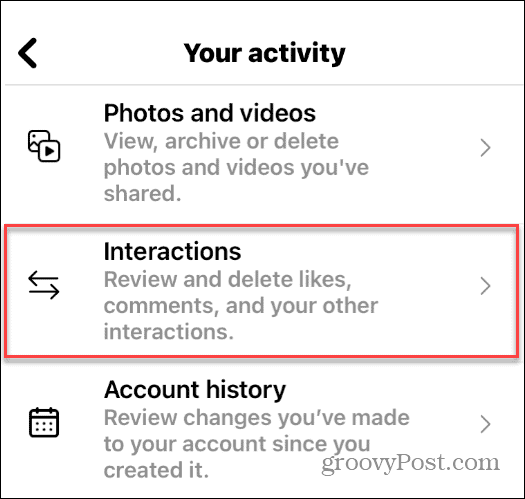
Instagram stores a history of all your liked posts, a handy feature that lets you look back at the photos and videos you liked over time. Open the Instagram app. Go to the profile tab and tap the three horizontal lines. Select Your Activity. Tap on Interactions > Likes. Now you can see the 300 most recent posts you liked ranked from newest to oldest. Use the Sort & Filter option to sort the posts based on author, start date and end date.

Picture Credit : Google