Category Seashores

WHICH IS THE LONGEST NATURAL SAND BEACH?

Cox’s Bazar in Bangladesh is the world’s longest natural sea beach. This beach distinguishes being the world’s longest ‘natural sea’ beach, stretching across 93 miles. It’s an exciting place that is one of the most popular tourist attractions in Bangladesh but remains relatively little known amongst tourists since Bangladesh is not considered a top destination for the average family.

The people who go here will find three different spots to enjoy: Laboni Beach, the main beach close to town, Humchari, which is loved for its waterfalls, and Inani Beach, which is favoured for suntanning. You may hear people here calling the beach Panowa; the term means ‘little flower’ and is the nickname that locals know the place by.

Credit: BEST TOPPERS

Picture Credit : Google

HOW ARE COASTS FORMED?

When waves, tidal waves in particular, hit land, the force of water has the power to break and crush rocks and to erode the soil. But they also bring in seashells, seaweed, other organic matter and debris from the sea, which all gets mixed and deposited among the crushed rocks to shape the coastline. Coasts are formed over hundreds of years and can be quite changeable, changing with time as tidal waves constantly crush, erode, wash away, bring in and deposit materials.

The coast, also known as the coastline or seashore, is defined as the area where land meets the ocean, or as a line that forms the boundary between the land and the ocean or a lake.

Geologists classify coasts on the basis of tidal range into macrotidal coasts with a tidal range greater than 4 meters (13 feet); mesotidal coasts with a tidal range of 2 to 4 meters (7 to 13 feet); and microtidal coasts with a tidal range of less than 2 meters (7 feet). The distinction between macrotidal and mesotidal coasts is more important. Macrotidal coasts lack barrier islands and lagoons, and are characterized by funnel-shaped estuaries containing sand ridges aligned with tidal currents. Wave action is much more important for determining bedforms of sediments deposited along mesotidal and microtidal coasts than in macrotidal coasts

Waves erode coastline as they break on shore releasing their energy; the larger the wave the more energy it releases and the more sediment it moves. Coastlines with longer shores have more room for the waves to disperse their energy, while coasts with cliffs and short shore faces give little room for the wave energy to be dispersed. In these areas, the wave energy breaking against the cliffs is higher, and air and water are compressed into cracks in the rock, forcing the rock apart, breaking it down. Sediment deposited by waves comes from eroded cliff faces and is moved along the coastline by the waves. This forms an abrasion or cliffed coast.

Credit: Wikipedia

Picture Credit : Google

HOW ARE WAVES FORMED?

When sunlight enters Earth’s atmosphere, the energy from the Sun heats up the air. This hot air expands and rises, creating space under it for cooler air to rush in. This movement causes winds. Winds that blow over the surface of ocean water transfer energy to the water, setting off ripples. As these ripples get bigger, they become waves.

The ocean is in constant motion. Waves form as a result of the water’s motion, gravitational forces, and winds. The most common waves we see are created by wind. However other waves include those created by gravitational forces (e.g. tidal waves) and those created by underwater disturbances, such as earthquakes (e.g. tsunamis).

There are three main factors that affect wave formation: wind velocity, fetch, and duration. Wind velocity is the speed of the wind, fetch is the distance over the water that the wind can blow uninterrupted (which can be huge distances out at sea), and duration is the amount of time the wind blows over that patch of water. The greater the wind velocity, the longer the fetch, and the greater duration the wind blows, then the more energy is converted to waves and the bigger the waves. However, if wind speed is slow, the resulting waves will be small, regardless of the fetch or duration. It takes all three factors acting together to create big waves.

Waves often result from storms, which tend to move across the ocean with the prevailing winds. So although a storm might only have 500 nautical miles (nm) of fetch, the storm can travel greater distances, say 1,000 nm, creating a travelling fetch of more than 1,000 nm.

Credit: UBC EOAS

Picture Credit : Google

HOW IS A ROCK ARCH CREATED?

When a high, rocky outcrop juts out into the water, the crashing of waves over the years erodes the base. If the layer of rock higher up stays intact as the base is worn through, a natural rock arch is carved out.

Most people understand that erosion plays an important role in creating arches and bridges. A natural rock arch is formed by erosion. There are two types of erosive forces that account for most arches and bridges – weather erosion and water erosion.

If a crack forms in the soft layers of a sandstone fin, it allows wind to penetrate into the rock. In the desert, winds are common, and they carry lots of sand – kind of like a natural sandblaster – this can cause the cracks to widen. Acidic rain can accumulate in these cracks, chemically weakening the rock. Then, freezing and thawing frosts can cause fractured sections of rock to break off. With enough time, the constant cycle of wind, ice and rain will form an arch. This is weather erosion, and most arches and bridges throughout the world were formed this way.

Water erosion relies, as the name suggests, almost entirely on running water to create arches and bridges. Streams and rivers may eventually cut through a fin of sandstone (this is how Rainbow Bridge was formed) or acidic rain-water might pool in depressions and create an arch from above (Double Arch in Arches National Park is the perfect example of this).

Credit: NATURAL UNIVERSAL SECRETS

Picture Credit : Google

WHAT IS A SHINGLE BEACH?

When stone, pebbles and small rocks are deposited along the coast, they create a porous layer that is not as tightly packed together as sand is. These are shingle beaches. Common to New Zealand, Japan and the United Kingdom, shingle beaches support little vegetation and mostly have lichen-covered rocks.

The term shingle beach refers to a beach along any body of water that is made up of stones, pebbles, and other small rocks. These materials, also known as shingles, may vary in size from 2 to 200 millimeters and can also be mixed with other sediments, like sand or silt. Shingle beaches are primarily characterized by a steep profile, which means the area further inland sits at a higher elevation than the section of the beach found along the water. These beaches are located along a number of geological formations, including spits, barrier islands, and pocket beaches. Since the stones and pebbles that make up these beaches do not fit tightly together, they create a rather porous environment. These large pores prevent the beach from retaining any significant amount of water, although they also prevent evaporation in the soil below. Many shingle beaches can be found in New Zealand, Japan, and the United Kingdom.

Geologists have linked the formation of many shingle beaches to areas around the world that were subjected to glaciation during the Pleistocene era. These areas tend to be located at higher latitudes, and glaciers brought with them rocks and pebbles that were deposited on the shorelines. Sometimes the rocks and pebbles on shingle beaches are deposited by rivers that empty into the ocean. Additionally, shingle beaches may be formed from intense wave activity that erodes larger pieces of rock located further inland. Over time, continued wave activity carries these large pieces of sediment onto the shores, depositing the biggest pieces further from the water and at higher elevations. The composition of these beaches works to decrease the strength of the tide as it moves back out to the ocean.

Credit: World Atlas

Picture Credit : Google

WHAT IS A COAST?

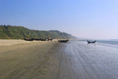
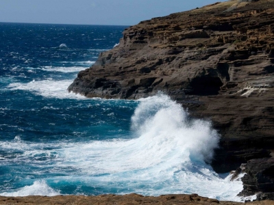
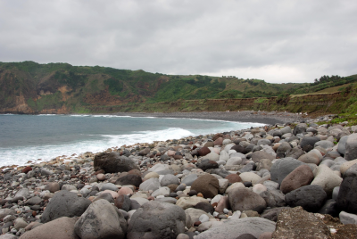
Land that runs along a sea or ocean is called a coast. The edge of the land where it meets the water is called the coastline. Coasts can be wide swathes of soft, sandy beaches, narrow, rocky stretches or sheer cliff faces. Coastlines are given shape by waves, currents and tides. They are ever changing and form an important and unique environment.

If you’ve ever been to the beach, you’ve been on a coast. The coast is the land along a sea. The boundary of a coast, where land meets water, is called the coastline.

Waves, tides, and currents help create coastlines. When waves crash onto shore, they wear away at, or erode, the land. But they also leave behind little parts of the sea, such as shells, sand dollars, seaweeds, and hermit crabs. Sometimes these objects end up as more permanent parts of the coastline.

Coastal changes can take hundreds of years. The way coasts are formed depends a lot on what kind of material is in the land and water. The harder the material in the land, the harder it is to erode. Coastlines of granite, a hard rock, stay pretty stable for centuries. Sugarloaf Mountain, on the coast of Rio de Janeiro, Brazil, is made mostly of granite and quartz. It has been a landmark for centuries.

Tides, the rise and fall of the ocean, affect where sediment and other objects are deposited on the coast. The water slowly rises up over the shore and then slowly falls back again, leaving material behind. In places with a large tidal range (the area between high tide and low tide,) waves deposit material such as shells and hermit crabs farther inland. Areas with a low tidal range have smaller waves that leave material closer to shore.

Credit:  National Geographic Society

Picture Credit : Google