Category Mountains

Is Meghalaya the wettest place on Earth?

Mawsynram in Meghalaya is the wettest place, based on rainfall in the world. Located in the Khasi Hills, it receives about 11,872mm (nearly 467 inches) of average annual rainfall According to the Guinness Book of World Records, the region received 26,000mm of rainfall in 1985. The mountainous terrain of Mawsynram and the nearby Cherrapunji, the second wettest place, are known for their lush greenery and scenic beauty The “living bridges are one of the most beautiful features of this region. These have been created by the local people by training the roots of rubber trees into natural bridges. With the root systems constantly growing, these bridges are self-sustaining.

Primarily due to the high altitude, it seldom gets truly hot in Mawsynram. Average monthly temperatures range from around 11 °C in January to just above 20 °C in August. The village also experiences a brief but noticeably drier season from December until February, when monthly precipitation on average does not exceed 30 millimetres (1.2 in). The little precipitation during the village’s “low sun” season is something that is shared by many areas with this type of climate.

Three reasons can be cited for high rainfall at Mawsynram:

The warm moist winds of the northward-moving air from the Bay of Bengal during the monsoon, which cover an extensive area but are forced to converge into the narrower zone over the Khasi Hills, thus concentrating their moisture.
The alignment of the Khasi Hills (east to west) places them directly in the path of the airflow from the Bay of Bengal, producing a significant uplift (plus cooling, further condensation and thus more rain).
Finally, uplift over the Khasi Hills is virtually continuous in the monsoon period because the lifted air is constantly being pulled up by vigorous winds in the upper atmosphere; hence, the rainfall is more or less continuous.

Picture Credit : Google 

Which is the highest mountain in the world?

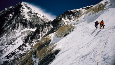
Mount Everest, located in the Himalayas, is the highest mountain above sea level. The China-Nepal border is across its summit point. In 2020, the Chinese and Nepali authorities marked its elevation as 8,848.86 m. Mount Everest is highly revered by local people like most other mountains in the range and is known as Chomolungma in Tibetan. It means Goddess Mother of the World or Goddess of the Valley. It was identified as the highest point on the Earth’s surface in 1852, when the governmental Survey of India established this fact. It was previously named Peak XV but was renamed in 1865 to honour Sir George Everest, the British surveyor general of India from 1830 to 1843.

British mountaineers made the first recorded efforts to reach Everest’s summit. Nepal did not allow foreigners to enter the country at that time, so the British made several attempts from the Tibetan side. The first expedition by the British in 1921 reached 7,000 metres on the North Col, a pass connecting Mount Everest and Changste, a mountain in Tibet. Another expedition in 1922 reached up to 8,320 metres, making it the first instance of a human being’s climb above 8,000 metres. Tenzing Norgay and Edmund Hillary reached the summit of the world’s highest mountain on May 28, 1953 at 11:30 am local time.

Picture Credit : Google

Why is Andes called the longest mountain range?

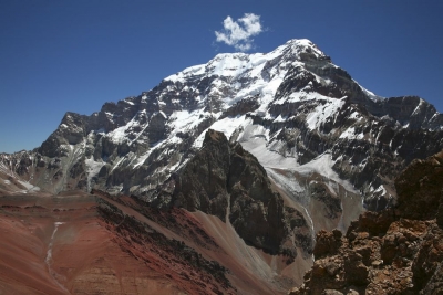
The Andes mountain range extends from north to south through seven South American countries and is 8900 kilometres long and about 200 to 700 kilometres wide. It is spread across Venezuela, Colombia, Ecuador, Peru, Bolivia, Chile, and Argentina with an average height of 4000 metres. In fact, the Andes range has some of the tallest peaks in the world. The only mountains that are taller than the Andes are the Himalayan Mountains and their adjacent ranges like the Hindu Kush. The highest elevation in the Andes range is for Mount Aconcagua in Argentina. It is 6,962 metres above sea level. The average elevation along the range is about 3,962 metres.

The world’s highest volcano, Ojos del Salado, when measured above sea level, is part of the Andes. It is located on the Chile-Argentina border. This vast mountain range is also home to a number of cities including Huaraz and Cuzco in Peru; Quito in Ecuador; La Paz of Bolivia; Bogota and Medellin in Colombia; and Pucon and Puerto Natales in Chile.

Animals in the Andes have to be very rugged and agile. They have to keep themselves warm in order to survive the harsh climate of the region. Chinchillas are one of the popular animals of this region. Their fur gets thicker in the higher altitudes as it gets colder and their ability to jump and climb serves as a protection from predators. Llamas, alpacas and the Andean condor, which is the largest vulture in South America, are some other wild animals to be found here. The Andes is also home to a wide variety of plant population; it nurtures about 30,000 species of plants.

Picture Credit : Google 

Have you heard about Mount Kalam?

There is a story behind this mountain which is named after Kalam.

In October 2015, two adventure enthusiasts Arjun Vajpai and Bhupesh Kumar climbed a peak in the Himalayas which was 6180 m above sea level. No one had explored this peak till then. It overlooked the Spiti Valley.

They hoisted the Indian flag there, celebrating their joy. They named it Mount Kalam to inspire young mountaineers.

The climb is dangerous as snow covers the deep crevasses that are hidden beneath. We get a terrific view of the Himalayan landscape from the altitude of 19,000 feet.

Picture Credit : Google

WHAT IS HAPPENING TO THE ALPS GLACIERS?

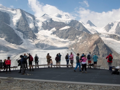
The Alps glaciers in Switzerland are on track for their highest mass losses in at least 60 years of record keeping, data shared exclusively with Reuters shows. By looking at the difference in how much snow fell in winter, and how much ice melts in the summer, scientists can measure how much a glacier has shrunk in any given year. Since last winter, which brought relatively little snowfall, the Alps have sweltered through two big early summer heatwaves.

During this heatwave, the elevation at which water froze was measured at a record high of 17,000 feet – at an altitude higher than Mont Blanc’s compared with the normal summer level of between 9,800-11,500 feet.

“It’s really obvious that this is an extreme season,” Swiss glaciologist Andreas Linsbauer said, shouting over the roar of rushing meltwater as he checked the height of a measuring pole jutting out of the ice on the massive Morteratsch Glacier in Switzerland. The measuring poles he uses to track changes in the depth of the pack are at risk of dislodging entirely as the ice melts away and he needs to drill new holes.

Vanishing glaciers are already endangering lives and livelihoods. Further, Swiss residents worry that the glacier losses will hurt their economy. Some area ski resorts of the Alps, which rely on these glaciers, now cover them with white sheets to reflect sunlight and reduce melting.

Mountain meltdown

Most of the world’s mountain glaciers-remnants of the last ice age-are retreating due to climate change. But those in the European Alps are especially vulnerable because they are smaller with relatively little ice cover. Meanwhile, temperatures in the Alps are warming at around 0.3C per decade-around twice as fast as the global average

If greenhouse gas emissions continue to rise, the Alps glaciers are expected to lose more than 80% of their current mass by 2100. Many will disappear regardless of whatever emissions action is taken now, thanks to global warming baked in by past emissions, according to a 2019 report by the UN Intergovemmental Panel on Climate Change

The dire situation this year raises concern that the Alps glaciers might vanish sooner than expected. With more years like 2022, that could happen, said Matthias Huss who leads Glacier Monitoring Switzerland (GLAMOS). “We are seeing model results expected a few decades in the future are happening now.” Huss said. “I not expect to see such an extreme year so early in the century.”

ALPS FACTS

• Located within the continent of Europe, the Alps mountain range is more than 1,000 km long.

• Though it spans several countries from France to Albania, it is Switzerland and Austria that are considered to be the Alpine heartland.

• The Alps is crucial for the livelihood of Europe as it provides water for drinking, irrigation, and hydroelectric power.

• Given its vastness and varied mountain elevation, the Alps has a huge impact on the weather patterns and the natural environment of the continent. In short, when the Alps is affected, it will have a bearing on several parts of the continent.

Himalayan thaw

Himalayan glaciers are also on track for a record ice loss year. When the summer monsoon season arrived in the Kashmir region, for example, many glaciers had already shrunk drastically, with their Snowlines starting high up the mountain, after a March-May heatwave marked by temperatures above 48C in northern India. An early June expedition in India’s Himachal Pradesh found that the Chhota Shigri Glacier had lost much of its snow cover. “The highest temperature in over a century in March through May clearly had its impacts,” said glaciologist Mohd Farooq Azam at the Indian Institute of Technology Indore.

Picture Credit : Google 

WHAT IS THE TUNDRA?

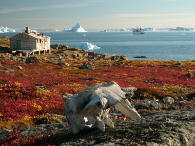
The tundra refers to a vast, flat, treeless Arctic region of Europe, Asia, and North America in which the subsoil is permanently frozen. Tundra ecosystems are also found on the mountaintops here, where the climate is cold and windy, and rainfall is scant. These lands are covered with snow for much of the year, which melts during the summer. Yet it hosts a few species of wildlife acclimatised to harsh conditions. As the tundra faces the threat of global warming, so do its inhabitants.

Plants and Animals in Tundras:

Mountain goats, sheep, marmots, and birds live in mountain—or alpine—tundra and feed on the low-lying plants and insects. Hardy flora like cushion plants survive in the mountain zones by growing in rock depressions, where it is warmer and they are sheltered from the wind.

The Arctic tundra, where the average temperature is -34 to -6 degrees Celsius (-30 to 20 degrees Fahrenheit), supports a variety of animal species, including Arctic foxes (Vulpes lagopus), polar bears (Ursus maritimus), gray wolves (Canis lupus), caribou (Rangifer tarandus), snow geese (Anser caerulescens), and musk oxen (Ovibos moschatus). The summer growing season is just 50 to 60 days, when the sun shines up to 24 hours a day.

The relatively few species of plants and animals that live in the harsh conditions of the tundra are essentially clinging to life. They are highly vulnerable to environmental stresses like reduced snow cover and warmer temperatures brought on by global warming.

Climate Change Impact on Tundras

The Arctic tundra is changing dramatically due to global warming, a term that falls within a wider range of trends scientists now prefer to call climate change. The impacts in this region are broad and somewhat unpredictable. Animals that are typically found farther south, like the red fox (Vulpes vulpes), are moving north onto the tundra. This means the red fox is now competing with the Arctic fox for food and territory, and the long-term impact on the sensitive Arctic fox is unknown.

Other tundra denizens, such as the wolf spider (Lycosidae spp.), are growing bigger and thriving. Shrubs are getting taller, contributing to declines in the sensitive groups of lichen that caribou and other species depend on for food. Lakes and ponds are evaporating or draining away.

Ctedit : National geographic society 

Picture Credit : Google