Category People and places

What is the Attari-Wagah retreat ceremony?

Do you know that booking for witnessing the Attari-Wagah retreat ceremony on India-Pakistan international border goes online?

If you have been following the news, you might have read that booking for the Attari-Wagah retreat ceremony can be made online. The online booking facility opens on Jan 1, 2023. What is this ceremony and when can it be watched? Let’s find out.

A daily ceremony

The Attari-Wagah front is along the India-Pakistan international border in Punjab. The Attari-Wagah retreat ceremony the daily national flag lowering and retreat ceremony taking place along the border. It is open for viewing by visitors. Symbolising rivalry as well as brotherhood and cooperation between the two nations, the purpose of the Attari-Wagah retreat ceremony is to formally close the gate at the border for the night. The Border Security Force (BSF) that guards the frontier conducts the event. The Attari border front, also called the joint check post or JCP, is located about 26 km from Amritsar city, and hundreds of domestic visitors and foreign tourists watch the daily ceremony conducted in a synchronised manner by smartly-dressed BSF personnel along with their counterparts, the Pakistan Rangers, on their side known as Wagah.

The background

India and Pakistan have been traditionally hosting the evening flag-lowering ceremony on the Attari-Wagah border since 1959 and the event is attended by people from both the countries on their respective sides. The ceremony which starts between 3.30 and 4 every evening lasts 60-120 minutes. The synchronised ceremony involves lowering of the flags of the two countries, foot stomping manoeuvres of the troops and loud shouts with patriotic songs being played in the background on either side. The ceremony ends with a retreat after a brief handshake between the soldiers on both sides.

Web portal launched

At present, people reach the retreat area without prior booking and the BSF allows them to take seats in the gallery on producing an ID card. A web portal for people desiring to witness the joint retreat le ceremony in person – http://attari.bsf.gov.in – has been launched by the BSF.

Online booking can be made from January 1 onwards. The new facility is not chargeable and visitors will be initially allowed to book 12 persons in one group, 48 hours prior to the desired day, after furnishing photo ID card details online. The booking details will be sent through an SMS to the mobile number of the group leader or the first visitor listed.

The BSF has now numbered the seats in the viewing gallery so that it can hold about 20,000-25,000 visitors daily. The online booking will also allow the tourists to visit the BSF museum and border pillar No. 102 that is erected next to the Attari border gate.

Picture Credit : Google

What is the basic information about Libya country?

Though Libya’s economic future changed with the discovery of petroleum in the late 1950s, today it faces political turmoil.

Ranu Joardar

Libya is an oil-rich desert country, which in the past couple of years has become an important crossover for migrants intending to reach Europe. It is currently ranked 92 among the major economies. Let us know more about this North African country.

History

Historically, Libya was never heavily populated or a power centre. Before the discovery of oil in the late 1950s, the country was seen as poor in natural resources. It was mostly dependent upon foreign aid and imports for the maintenance of its economy.

The discovery of petroleum changed the fate of Libya. The country’s first productive oil well was struck in 1959 at Amal and Zelten, now known as Nasser. The country began exporting oil in 1961.

The first settlers of Libya were the Berbers during the Late Bronze Age, around 1200 BC. The land was then home to the Phoenicians (an ancient Mediterranean civilisation). They established coastal trading posts in the 7th Century BC

The name ‘Libya’ was given by the Greeks when they occupied the eastern part of the country. The country was also once part of the Roman empire.

Around 700 AD, the Arabs came and introduced Islam to the area. From the 16th Century, the country was under the Ottoman Empire until Italy conquered it in 1912. The French and British took over Libya during the Second World War in 1943.

Libya finally gained its independence in 1951. However, it was ruled by monarchs till 1969 when Colonel Muammar Gaddafi overthrew King Idris I.

Gaddafi controlled Libya until the 2011 revolution when he was killed. Despite achieving independence from autocratic rule, the country continues to rebuild its government.

Geography

The fourth-largest country in Africa is mostly a desert and most of its population lives along the coast and its immediate hinterland (region lying inland from a coast). The de facto capital, Tripoli, and Benghazi (second-largest city) are on the coast of the Mediterranean Sea.

Libya is surrounded by the Mediterranean Sea, Tunisia, Algeria, Niger, Chad, Sudan, and Egypt. As the country is part of the Sahara desert (the world’s largest hot desert), the country has no permanent rivers.

To access the water below the desert, the Great Man-Made River was constructed to deliver fresh water to the cities through a network of underground pipelines.

Flora and fauna

As the country’s coastal plains have high precipitation, these regions are home to herbaceous vegetation and annual grasses such as asphodel (a herb of the lily family).

The north of Akhdar mountains is covered with a dense forest of juniper and lentisc. Though the semiarid regions lack vegetation, the most commonly found plants here include saltwort (a plant used in making soda ash), spurge flax (a shrubby plant), goosefoot.

Asida is a popular traditional dish served in Libya during celebrations such as births or Eid. Wormwood, and asphodel.

The country is home to wild animals like desert rodents (desert hare and the jerboa), hyenas, foxes (fennec and the red fox), jackals, skunks, gazelles, and wildcats. Its largest national park, El Kouf National Park, is known for its sand dunes, wetlands, and hilly terrain.

The country’s native birds include wild ringdove, partridge, lark, and prairie hen.

People

About 97% of the country’s population consists of the Berber and Arab ethnic groups. Most Libyans speak Arabic, which is the country’s official language. At the beginning of the 21st Century, the country saw a rise in the number of foreign migrant workers, mainly from sub-Saharan African countries. About 25% population live either in Tripoli or Benghazi and the rest live near desert oases, where they can access water.

The country is famous for its weaving, embroidery, and metal engraving. Traditional Libyan food is a blend of North African.  Berber,  and Mediterranean cuisines. Couscous, lamb, dates, and olives feature heavily in the Libyan cuisine

Politics

Following independence, Libya was ruled by monarchs. After overthrowing King Idris I in 1969 and suspending the constitution in a military coup, the country turned into an authoritarian state. Till 1977, Libya was ruled by a 12-member Revolutionary Command Council (RCC) with Colonel Gaddafi as secretary-general. Though he resigned from the post in 1979, he continued to be the de facto ruler of the country and head of the revolution until he was killed during the 2011 revolution.

Since 2014, the country has had competing political and military factions fighting for power. Though the two sides signed a permanent ceasefire in 2020, political rivalries continue leaving the country in a turmoil. Currently, the Prime Minister of Libya is Abdul Hamid Dbeibeh, leader of the Government of National Unity (GNU).

Libya Revolt of 2011

On February 15, 2011, anti-government protests were held in Benghazi after the arrest of human rights lawyer Fethi Tarbel. The protesters demanded the resignation of Gaddafi and the release of political prisoners. The protests gained momentum despite the Libyan security forces using lethal force against demonstrators. Soon, international pressure for Gaddafi to step down increased and sanctions against the regime were imposed by the UN Security Council. On October 20, Gaddafi was killed by rebel fighters in his hometown.

Picture Credit : Google 

What makes country Georgia special?

Georgia is a country located at the crossroads of Eastern Europe and Western Asia. It is part of the Caucasus region, bound by the Black Sea, with Russia. Armenia, and Azerbaijan as its neighbouring countries. Even though it is quite small, the country has a lot to offer. It boasts of ancient cities, vibrant culture, and breathtaking landscapes. It is also referred to as ‘Sakartvelo’, as Georgians call themselves Kartavelians- meaning “land where Kartavelis Live”.

The Georgian kingdom has been under the hegemony of various regional powers, including the Mongols, the Ottoman Empire, and various dynasties of Persia. It was later invaded and annexed by the Soviet Union until the country got its independence in the early 1990s. Tbilisi is the current capital and largest city. It gets its name from an old Georgian word “tbili” which means “warm”. This old town features narrow streets and a variety of architectural styles, reflecting the influences of the various empires. making it feel like a journey through time. Most of the architecture consists of churches. monasteries with fine metalwork representing the Byzantine style

Georgian is the official language spoken, which is one of the oldest languages in the world. Strongly influenced by the Greek and Persian, Georgian evolved around 5th century. The interesting fact about the language is that it does not use gender or capital letters. It has 33 alphabets, with many dialects. Other Caucasian languages are also spoken in minority.

Picture Credit : Google

Kenya: Where history, nature, and culture meet

Often known as the cradle of humanity, Kenya has fossilised remains of hominids, is home to over 40 ethnic groups, and has the highest concentration of wild animals in the world.

Ranu Joardar

 Kenya, one of the countries in East Africa, has often been described as “the cradle of humanity”. It is an important business, financial, and transportation hub as about 80% of East Africa’s trade flows through its Mombasa Port.

History

Kenya’s history dates back to millions of years as some of the earliest fassilised remains of hominids have been discovered here. For instance, findings by anthropologist Richard Leakey in the Koobi Fora area along the shore of Lake Rudolf have included portions of ‘Australopithecus boisei’ and ‘Homo habilis’ (extinct species of human) skeletons.

 An important part of Kenyan history is slavery. During the 1600s and 1700s, most Kenyans were taken as slaves by the Arabs, Europeans, and Americans.

For several centuries, people from across regions have also settled in or travelled to Kenya. The Maasai tribe came to what is now known as central Kenya from north of Lake Rudolf (now called Lake Turkana in the Kenyan Rift Valley) in around mid 18th Century.

Geography

Kenya is surrounded by South Sudan, Ethiopia, Somalia, Indian Ocean, Tanzania, Lake Victoria, and Uganda.

The 38th meridian, the longitude that extends from the North Pole to the South Pole, divides Kenya into two halves. Kenya’s terrain rises from the low coastal plain on the Indian Ocean towards the mountains and plateaus.

The country’s capital, Nairobi, is at an altitude of 5,500 feet. From the west of Nairobi, the terrain descends to the Great Rift Valley, which has jade-green waters of famous Lake Turkana.

Kenya was the first African country to tap geothermal energy (heat energy from the Earth). The Hell’s Gate National Park’s geysers and hot springs are used to harvest geothermal energy and fuel almost half of Kenya’s electricity.

Flora and fauna

Kenya’s highlands consist of patches of evergreen forest separated by wide expanses of short grass. The forests have economically valuable trees such as cedar and varieties of podo.

Kenya’s ecosystem includes deserts, swamps, and even glaciers on Mount Kenya, Africa’s second highest peak. Each region has different plants and animals suited to the area’s particular conditions. The semi-desert regions below 3,000 feet have baobab trees.

The Masai Mara, situated in south-west Kenya, is one of Africa’s greatest wildlife reserves. It is named after the Maasai tribe, the ancestral inhabitants of the area. It has the highest concentration of wild animals in the world and over 40% of Africa’s larger mammals can be found here. During the migration, over 1.5 million wildebeest migrate from southern Serengeti (in Tanzania) to the Masai Mara. They travel 800 km clockwise in a circle through the Serengeti and Masai Mara ecosystems to search for greener mineral-rich pastures and water. The annual migration at the end of the rainy season (usually in May or June) is recognised as one of the “Seven Wonders of the Natural World”.

The country’s wildlife population is mostly found outside the country’s numerous national parks and game reserves. For instance, baboons and zebras are found along the Nairobi-Nakuru highway, near human settlements and urban centres.

The rainforests in highlands have various large mammals such as elephants and rhinoceroses. Besides, bushbuck, colobus monkeys, and galagos are also found in the region. The highlands have predators such as lions, leopards, and wildcats.

People

The land is home over 40 ethnic groups such as Kikuyu, Luhya, Kalenjin, Maasai, Luo, and Kamba. The country is divided into three language groups- Bantu, Nilo-Saharan, and Afro-Asiatic.

In the 19th Century, several Indians and Pakistanis came to the region, thus influencing the country’s language – Swahili. Swahili evolved along the coast from elements of local Bantu languages-Arabic, Persian, Portuguese, Hindi, and English. It is the lingua franca, a language used as a means of communication, between populations speaking vernaculars that are not mutually intelligible. It is also the language of local trade and is used along with English as an official language in the Kenyan legislative body, the National Assembly, and the courts.

Most Kenyans live in the highlands. Most of the population is rural and live in scattered settlements. Before European colonisation, the urban areas constituted only the fishing regions, Arab trading ports, and towns that were visited by dhows (sailing boats) from the Arabian Peninsula and Asia. People began migrating from the rural to the urban areas after the country’s independence in 1963.

Music and storytelling are important parts of the Kenyan culture. For centuries, the tribes used songs, stories, and poems to pass on their beliefs, history, and customs. Though school is free of cost, most children have to help their families by working the land, tending cattle, cooking, or fetching water.

Government

The country was a colony of the United Kingdom from 1920 till its independence on December 12, 1963 (known as the Jamhuri Day). The first President Jomo Kenyatta was an icon of the liberation struggle, who led Kenya from 1963 until his death in 1978, when Vice-President Daniel arap Moi took power in a constitutional succession.

According to the first constitution after independence, the Prime Minister was appointed as the head of a cabinet chosen by a bicameral National Assembly. Over the years, several constitutional reforms were made, and in 2010 a new constitution was promulgated. The country is now a republic, with a President, a national assembly, called the Bunge, and a legal system.

Picture Credit : Google 

What are the interesting facts about Croatia?

Croatia is located in the northwestern part of the Balkan peninsula. The country declared its independence from Yugoslavia in 1991. However, it faced four years of war and a decade of authoritarian nationalism under President Franjo Tudjman.

History

Historically, Croatia was a bridge connecting the central European and Mediterranean worlds.

The first Croats settled here around 500 AD. From 1868 till the end of World War II, it was ruled by Hungary and then it became a part of Yugoslavia.

In the early 1990s, Communism collapsed in eastern Europe. While being part of Yugoslavia, different ethnic groups in the Croatian region began to fight for power and independence.

After Croatia declared its independence in 1991, a civil war began between the Croatians and Serbians. The war came to an end with the signing of the Dayton Agreement in December 1995.

After the fall of Communism in Croatia, the government converted the economy from the Yugoslav system of socialist self-management to market-oriented capitalism.

Geography

The country is small, crescent-shaped, and geographically diverse. It has low mountains and highlands near the Adriatic coastline.

There are flat plains near the Hungarian border. Near the mountainous regions, winters are snowy and the summers are mild. The coastal areas have hot, sunny summers and mild winters. The highest mountain here is Dinara, located in the central mountain belt.

Flora and fauna

Due to the country’s diverse geography, the flora and fauna are also varied. While on the Dalmatian coast, grapes and olives are grown, Istria is covered with firs, and Slavonia has oak forests.

The country has wolves, bears, hares, foxes, boars, wildcats, and mouflons (wild sheep). The sea life in the Adriatic includes several coral reefs, and underwater caves serve as habitats.

People

There are several ethnic groups in the country. Croats are the largest ethnic group. Serbs are the largest minority group though their population decreased after the 1990s war of independence.

The other populations include Bosnian Muslims, Hungarians, Italians, and Slovenes as well as some Albanians, Austrians, Bulgarians, Czechs, Germans, and other nationalities.

The diversity in population has influenced its cuisine. Along the coast, fish is served with blitva, which is a Swiss chard mixed with potatoes and garlic in olive oil.

The country’s literary history dates back to about 1100. The first book in the Croatian language was Hrvoje’s Missal, a liturgical text printed in 1483.

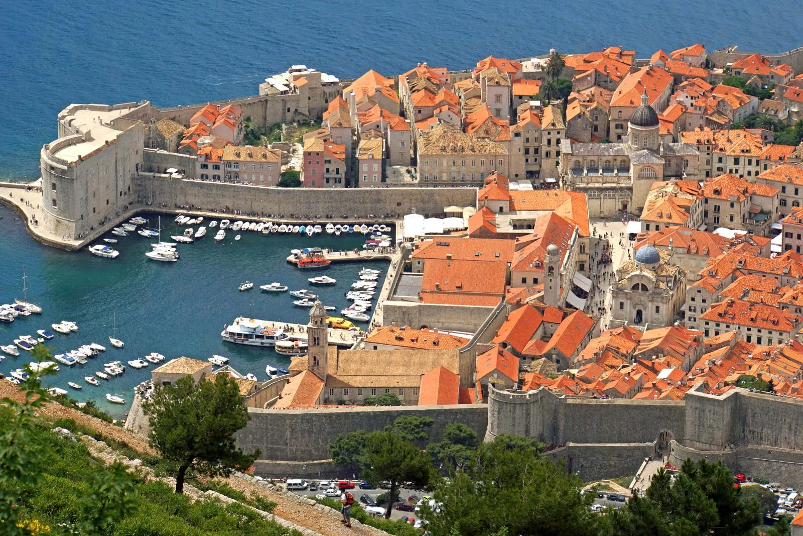
UNESCO has included several sites on its World Heritage List, such as the old city of Dubrovnik and Split, which contains the ruins of the palace of Roman emperor Diocletian.

Sports in Croatis dates back to the Roman times (medieval knights’ tournaments). The organised sport began in the country in late 19th Century, when the first sports associations were founded. In 1874, Hrvatski Sokol (Croatian Falcon) was founded. It soon became the largest organisation in the country promoting modern gymnastics and other branches of sports such as cycling, fencing, equestrianism, athletics, skating, tennis, etc.

Government

By early 2003, Slovenia became the second former Yugoslav republic to have applied for membership in the European Union (EU). On July 1, 2013, the country became the 28th member state of the EU.

The President is elected by a popular vote to a five-year term. However, his role is mainly ceremonial. Though the President appoints the Prime Minister, the parliament approves the nomination.

Picture Credit : Google 

Did you know Norway is the natural habitat of reindeer?

Or that the animals are perfectly adapted to life in the Arctic Circle? Here is an account of a wildlife conservationist that throws light on the snow-covered landscape and the animals owned and cared for by the traditional Sami people.

Many years ago, I joined a team of wildlife experts and travelled to Norway, near the Arctic Circle. This is the natural habitat of reindeer. Apart from wild reindeer or caribou, there were hundreds of almost tame ones that were herded by a traditional community called the Sami.

It was the most amazing snow-covered landscape-the entire ground was white as far as the eye could see. It was freezing cold and though all of us wore several layers of sweaters and jackets, our hosts gave each of us a full snowsuit with a hood, snow boots and thick gloves.

The reindeer herd was out grazing in a pasture far away. We travelled in motorised sleds to see them. It was a thrilling but scary ride. The young Sami man driving the vehicle took us at breakneck speed over the powdery snow, swerving expertly between trees and almost flying up and down slopes. I held on tight, grateful for the snowsuit that protected me from the chilly wind and icy spray of snow that blew up in our wake.

From a distance, the reindeer looked like dark shadows against the almost blinding whiteness of the snow-covered open meadow. As we approached, they continued to graze peacefully. They were semi-domesticated, allowed to roam free without being tied up or confined, yet owned and cared for by the Sami families. There were about a hundred reindeer in the herd with many fawns. The adults looked majestic with their crowns of beautiful branching antlers.

Cone-like tents or Lavvus

Sami families move along with their herds and camp in huge inverted cone-like tents called ‘lavvu’ wherever they want to stop. Reindeer are big animals-almost like horses. Both males and females have antlers and they are sturdy and strong with long legs to help them walk in deep snow.

Reindeer have two layers of fur to keep out the cold-a fluffy inner layer and a hairier outer one. Even their hooves are hard and horny to enable them to walk easily on ice and snow.

Interestingly, the fawns are born in winter. They have extra fat in their bodies which insulates them against the intense cold.

In short, they are perfectly adapted to life in the Arctic Circle, where the temperature is below zero for much of the year.

Looking for lichen

I wondered what they were eating, because there was not a blade of grass or leafy bush to be seen anywhere! Then I noticed the big reindeer were digging the ground with their forelegs. They were looking for lichen or ‘reindeer moss’ growing on the rocks underneath. This was the only food available to them in winter. Lichens are a combination of a fungus and an alga. Usually they are found on the bark of trees or on stones and rocks. The reindeer use their sharp hooves to scrape it off from rocks and boulders that lie beneath the snow.

When the snow thaws in summer, the ground becomes marshy and spongy, so the reindeer’s hooves develop pads to help them to walk and run. In the few months of the short Arctic summer, grasses and plants grow quickly and abundantly. The reindeer then feed on the lush, fresh vegetation till winter returns.

Dressed in woollen fabric

After showing us the herd, our host took us to a group of tents belonging to Sami families. A few women and men came out to greet us, dressed in colourful red and blue traditional coats made of embroidered woollen fabric and wearing elaborate reindeer fur hats and thick boots also made of fur. They invited us to have dinner and spend the night in their home which was a typical lavvu. The snow all around was so soft and deep that I sank up to the knees with every step. I envied the reindeers long, strong legs!

In the centre of the lavvu, I was surprised to find a log fire burning with a huge pot of steaming stew on it! After a meal of delicious stew, bread and jam served by our hosts. I crawled into a sleeping bag as near the glowing fire as possible. I was still wearing the full snowsuit with its fur-lined hood to cover my head, as well as thick gloves and wool socks, yet the bitter cold had me shivering and sleepless all night. I was filled with admiration for the Sami, as well as for the reindeer, who had both adapted to such a harsh climate.

Picture Credit : Google