Category Rivers

HOW OLD IS THE COLORADO RIVER?

Colorado River, major river of North America, rising in the Rocky Mountains of Colorado, U.S., and flowing generally west and south for 1,450 miles (2,330 kilometres) into the Gulf of California in northwestern Mexico. Its drainage basin covers 246,000 square miles (637,000 square kilometres) and includes parts of seven states—Wyoming, Colorado, Utah, New Mexico, Nevada, Arizona, and California. For 17 miles the river forms the international boundary between the U.S. state of Arizona and Mexico. The river drains a vast arid and semiarid sector of the North American continent, and because of its intensive development it is often referred to as the “Lifeline of the Southwest.”

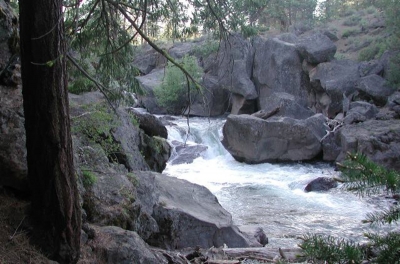
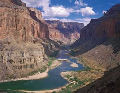
For more than a thousand miles of its course, the Colorado has cut a deep gorge. Where the river system is joined by lateral streams—the Virgin, Kanab, Paria, Escalante, Dirty Devil, and Green rivers from the west, and the Little Colorado, San Juan, Dolores, and Gunnison from the east—a transverse system of narrow, winding deep canyons has been cut. Each entering river and each lateral creek has cut another canyon, and thus the upper and middle parts of the Colorado basin are traversed by a labyrinth of deep gorges. The longest of these unbroken trunk canyons through which the Colorado flows is the spectacular Grand Canyon, extending from the mouth of the Paria to the Grand Wash Stream. Other canyons cut by the river include Marble Canyon, Glen Canyon, and Cataract Canyon. Canyonlands National Park encompasses another of these regions at the juncture of the Green and Colorado rivers in southeastern Utah.

Credit: Britannica

Picture Credit : Google

HOW OLD IS THE NILE RIVER?

The Nile River flowing through Egypt could be six times as old as previously thought, according to a study which estimated it to have originated at least 30 million years ago. The study, published in the journal Nature Geoscience, assessed the links between the geographical and physical features — or topography — of the Nile River to the flow of molten rocks in the Earth’s mantle.

The researchers, including those from the University of Texas (UT) at Austin in the US, connected the tilted nature of the Nile’s topography to a conveyor belt of mantle rock pushing up against the Ethiopian Highlands in the south, and pulling the surface down in the north. This gentle gradient, they said, keeps the Nile on a consistent northward course from its beginning to the end. The study said the Nile would have turned west long ago — probably changing the course of history along with it — if it weren’t for the mantle movement keeping the river on course.

Picture Credit : Google 

HOW DO RIVER CURRENTS IMPACT THE LANDSCAPE?

Current refers to the speed of the movement of water. This can be very fast, especially in the mountains, close to the source of the river. River currents have tremendous power – they can tear out boulders and carry huge rocks and smash them deep into the riverbed. As the river reaches the plains, the current slows it down; causing it to deposit a lot of the debris it carried, creating a wider valley with fertile soil.

Rivers and streams begin their lives as smaller creeks, often called “the headwaters”. These small tributaries flow downhill until they merge to form bigger tributaries, which continue merging to form larger rivers. Rivers keep flowing to lower altitudes, towards the oceans. River systems are similar to the blood vessels in your body. Tiny capillaries that carry blood keep merging together until all of the blood empties into large veins, which deliver the blood to your heart.

All rivers are surrounded by a certain amount of land that is higher in altitude (upgradient) than the actual river. Precipitation that falls in this area eventually flows downhill towards the river. At any particular point on a river, the land upgradient of the point is the river’s watershed, or drainage basin. This example of a watershed gives a rough idea of how precipitation flows downhill into rivers (and lakes) movement of a fluid within a larger body of that fluid. Fluids are materials capable of flowing and easily changing shape. The most familiar natural fluid is water. But air is considered a fluid as well. Electricity can also flow as a current.

Air currents flow in the atmosphere, the layer of air surrounding the Earth. Water currents flow in rivers, lakes, and, oceans. Electric currents flow through power lines or as lightning.

Credit: usgs.gov

Picture Credit : Google

HOW MANY TRIBUTARIES DOES THE NILE RIVER HAVE?

The Nile in Africa is the longest river in the world. The river has three tributaries; the two main ones are the White Nile that begins in Burundi and the Blue Nile that has its source in Ethiopia. Both rivers merge in Sudan. The third tributary, Atbara River, is dry most of the year and flows only if it rains in Ethiopia.

The Nile River, considered the longest river in the world, is approximately 4,258 miles (6,853 kilometers) long, but its exact length is a matter of debate. Flowing northward through the tropical climate of eastern Africa and into the Mediterranean Sea, the river passes through 11 countries: Tanzania, Uganda, Rwanda, Burundi, the Democratic Republic of the Congo, Kenya, Ethiopia, Eritrea, South Sudan, Sudan and Egypt.

The Nile has two major tributaries: the longer White Nile, considered the prime stream and headwaters; and the Blue Nile, which carries about two-thirds of the river’s water volume and most of the silt.

The White Nile begins at Lake Victoria, Africa’s largest lake, which touches the countries of Uganda, Kenya and Tanzania. But Lake Victoria isn’t necessarily the most distant and “true” source of the Nile River because the lake itself has many feeder rivers coming in from the surrounding mountains. In 2006, a British explorer named Neil McGrigor said he’d traveled to the Nile’s most distant source at the beginning of the Kagera River, Lake Victoria’s longest feeder river.

Credit: Live Science

Picture Credit : Google 

WHAT IS AN OXBOW LAKE?

When a river flows through low-lying plains, it slows down, carving out a meandering path with many U-shaped curves. Over time, some of these curves become cut off from the main flow of the river by the build-up of silt deposits, and form oxbow lakes. These distinctive, curved water bodies are close to a river but separate from it.

An oxbow lake starts out as a curve, or meander, in a river. A lake forms as the river finds a different, shorter, course. The meander becomes an oxbow lake along the side of the river.

Oxbow lakes usually form in flat, low-lying plains close to where the river empties into another body of water. On these plains, rivers often have wide meanders.

Meanders that form oxbow lakes have two sets of curves: one curving away from the straight path of the river and one curving back. The corners of the curves closest to each other are called concave banks. The concave banks erode over time. The force of the rivers flowing water wears away the land on the meanders concave banks.

The banks opposite the concave banks are called convex banks. The opposite of erosion happens here. Silt and sediment build up on convex banks. This build-up is called deposition.

Erosion and deposition eventually cause a new channel to be cut through the small piece of land at the narrow end of the meander. The river makes a shortcut. Oxbow lakes are the remains of the bend in the river.

Oxbow lakes are stillwater lakes. This means that water does not flow into or out of them. There is no stream or spring feeding the lake, and it doesnt have a natural outlet. Oxbow lakes often become swamps or bogs, and they often dry up as their water evaporates.

Credit: National Geographic Society

Picture Credit : Google

Which are the major rivers and lakes in Ukraine?

Ukraine is blessed with several rivers and waterbodies. The most prominent among the rivers are the Dnieper River, the Southern Buh and the Danube. The longest river in Ukraine, Dnieper dominates the central region of the country with many tributaries and has several hydroelectric dams and huge reservoirs along its course to the Black Sea. The Southern Buh also flows into the Black Sea along with the Inhul, its major tributary. The Danube flows along Ukraine’s southwestern frontier.

Almost 3 per cent of Ukraine is marshland, which is mostly found in the northern river valleys and in the lower reaches of rivers like the Dnieper and Danube.

The rivers are a major source of water, and to enable its proper supply a series of canals have been built in Ukraine. There are dams and hydroelectric plants built on all the larger rivers.

Ukraine has a few natural lakes, too, but they are small in size. Lake Svitiaz in the northwest is one of the largest; with an area of 28 square km. Along the coast there are some saline lakes which are larger. There are also some artificial lakes, like the reservoir on the Dnieper near the city of Kremenchuk.

Picture Credit : Google