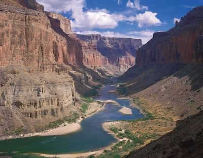
Colorado River, major river of North America, rising in the Rocky Mountains of Colorado, U.S., and flowing generally west and south for 1,450 miles (2,330 kilometres) into the Gulf of California in northwestern Mexico. Its drainage basin covers 246,000 square miles (637,000 square kilometres) and includes parts of seven states—Wyoming, Colorado, Utah, New Mexico, Nevada, Arizona, and California. For 17 miles the river forms the international boundary between the U.S. state of Arizona and Mexico. The river drains a vast arid and semiarid sector of the North American continent, and because of its intensive development it is often referred to as the “Lifeline of the Southwest.”
For more than a thousand miles of its course, the Colorado has cut a deep gorge. Where the river system is joined by lateral streams—the Virgin, Kanab, Paria, Escalante, Dirty Devil, and Green rivers from the west, and the Little Colorado, San Juan, Dolores, and Gunnison from the east—a transverse system of narrow, winding deep canyons has been cut. Each entering river and each lateral creek has cut another canyon, and thus the upper and middle parts of the Colorado basin are traversed by a labyrinth of deep gorges. The longest of these unbroken trunk canyons through which the Colorado flows is the spectacular Grand Canyon, extending from the mouth of the Paria to the Grand Wash Stream. Other canyons cut by the river include Marble Canyon, Glen Canyon, and Cataract Canyon. Canyonlands National Park encompasses another of these regions at the juncture of the Green and Colorado rivers in southeastern Utah.
Credit: Britannica
Picture Credit : Google


