Category Geography

HOW MUCH WATER DOES THE AMAZON CARRY?

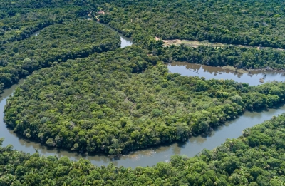
The Amazon River or River Amazon of South America has a greater total flow than the next six largest rivers combined. It is sometimes known as The River Sea. The Amazon is also regarded by most geographic authorities as the second longest river on Earth, the longest being the Nile in Africa.

The drainage area of the Amazon in Brazil, called the Amazon Basin, is the largest on Earth. If the Basin were an independent country, it would have more than twice the area of India.

The quantity of fresh water released by the Amazon to the Atlantic Ocean is enormous: up to 300,000 m³ per second in the rainy season. The Amazon is responsible for a fifth of the total volume of fresh water entering the oceans worldwide. It is said that offshore of the mouth of the Amazon potable water can be drawn from the ocean while still out of sight of the coastline, and the salinity of the ocean is notably lower a hundred miles out to sea. This mixture of fresh and salt water is known as brackish water.

This quantity of water causes the Amazon to have no clouds above the channel near its mouth. These are usually taken in the morning, when water is colder and land is beginning to be much warmer. Above big rivers (the Orinoco and Caura rivers in Venezuela and many more have the same characteristic), cold waters create a high pressure air mass which make rivers easy to see through clouds. On the contrary, during afternoons, clouds cover most river channels.

Credit: cs.mcgill.ca

Picture Credit : Google

HOW DO CANYONS FORM?

A canyon is a vast, bounded valley with steep, rising sides. Canyons are formed by weathering and erosion. Over millions of years, the land is continuously worn away by water. Rocks and silt on the riverbed are carried away by the river, which further gouges out a narrow channel-shaped landscape.

A canyon is a deep, narrow valley with steep sides. “Canyon” comes from the Spanish word cañon, which means “tube” or “pipe.” The term “gorge” is often used to mean “canyon,” but a gorge is almost always steeper and narrower than a canyon.

The movement of rivers, the processes of weathering and erosion, and tectonic activity create canyons.

River Canyons

The most familiar type of canyon is probably the river canyon. The water pressure of a river can cut deep into a river bed. Sediments from the river bed are carried downstream, creating a deep, narrow channel.

Rivers that lie at the bottom of deep canyons are known as entrenched rivers. They are entrenched because, unlike rivers in wide, flat flood plains, they do not meander and change their course.

Weathering and Erosion

Weathering and erosion also contribute to the formation of canyons. In winter, water seeps into cracks in the rock. This water freezes. As water freezes, it expands and turns into ice. Ice forces the cracks to become larger and larger, eroding bits of stone in the process. During brief, heavy rains, water rushes down the cracks, eroding even more rocks and stone. As more rocks crumble and fall, the canyon grows wider at the top than at the bottom.

When this process happens in soft rock, such as sandstone, it can lead to the development of slot canyons. Slot canyons are very narrow and deep. Sometimes, a slot canyon can be less than a meter (3 feet) wide, but hundreds of meters deep. Slot canyons can be dangerous. Their sides are usually very smooth and difficult to climb.

Tectonic Uplift

Canyons are also formed by tectonic activity. As tectonic plates beneath the Earth’s crust shift and collide, their movement can change the area’s landscape. Sometimes, tectonic activity causes an area of the Earth’s crust to rise higher than the surrounding land. This process is called tectonic uplift. Tectonic uplift can create plateaus and mountains. Rivers and glaciers that cut through these elevated areas of land create deep canyons.

Credit: National Geographic Society

Picture Credit : Google 

Which are the major rivers and lakes in Ukraine?

Ukraine is blessed with several rivers and waterbodies. The most prominent among the rivers are the Dnieper River, the Southern Buh and the Danube. The longest river in Ukraine, Dnieper dominates the central region of the country with many tributaries and has several hydroelectric dams and huge reservoirs along its course to the Black Sea. The Southern Buh also flows into the Black Sea along with the Inhul, its major tributary. The Danube flows along Ukraine’s southwestern frontier.

Almost 3 per cent of Ukraine is marshland, which is mostly found in the northern river valleys and in the lower reaches of rivers like the Dnieper and Danube.

The rivers are a major source of water, and to enable its proper supply a series of canals have been built in Ukraine. There are dams and hydroelectric plants built on all the larger rivers.

Ukraine has a few natural lakes, too, but they are small in size. Lake Svitiaz in the northwest is one of the largest; with an area of 28 square km. Along the coast there are some saline lakes which are larger. There are also some artificial lakes, like the reservoir on the Dnieper near the city of Kremenchuk.

Picture Credit : Google

Why is Kyiv a unique city?

The impressive capital of Ukraine, Kyiv boasts of a rich, ancient history. According to legends, this port city on the Dnieper River was founded by three brothers named Kyi, Shchek and Khoryv, and their sister Lybid.

The city-name Kyiv means ‘belonging to Kyi’. It acquired the title ‘Mother of Rus Cities’, a thousand years ago, as the centre of Kievan Rus. The city suffered heavy damages during World War II, but it was rebuilt and restored by the mid-1950’s. The second half the 20th century saw Kyiv flourishing with a well-developed economy and cultural life.

Ukraine became independent from the Soviet Union in 1991, and this enhanced the status of Kyiv as a major capital city in Europe.

The city has many higher education centres and hi-tech industries. There are famous historical landmarks, too, like the Saint Sophia Cathedral and Golden Gates of Kyiv.

Picture Credit : Google

Why is Siberia special?

Since the 17th century, Siberia has been a part of modern Russia. Siberia’s territory extends eastwards from the Ural Mountains to the watershed between the Pacific and Arctic drainage basins. Siberia is divided into the Western and the Eastern Siberia, by the Yenisei River. Siberia stretches southwards from the Arctic Ocean to the hills of north-central Kazakhstan and to the northern parts of Mongolia and China. Siberia’s western part consists of some territories of the Ural region and the far eastern part has been historically called the Russian Far East.

Siberia is renowned globally for its long, harsh winters, with a January average of – 25 °C. Even though it is geographically situated in Asia, due to it being colonized and incorporated into Russia, it is culturally and politically a part of Europe. Some scholars say the word “Siberia” is derived from the Mongolian word ‘Shaver’ (meaning swamp), while some others connect the word with the name of “Sabirs” – the people who once inhabited the steppes of Western Siberia. The spreading of the name for the entire territory of Siberia happened due to the Russian advance in the 17th century.

The area of Siberia is 12.6 million square kilometres, which is 74 per cent of the whole territory of Russia. Can you imagine what this is like? It is almost 25 times the area of France!

Siberia is also home to the largest swamp in the world – the Vasyugan swamp. It is 20 per cent wider than the whole of Switzerland and it has more than 800 lakes within its limits. This swamp also contains the world’s largest deposits of peat. Apart from this, Siberia is home to Lake Baikal as well.

Picture Credit : Google 

Why is it said that Russia is home to a large number of ecosystems and various animal species?

It is not surprising that a country so big is home to a large number of ecosystems and species. Its forests, steppes, and tundras are an ideal habitat for many rare animals, like pikas and Siberian tigers.

Russia set up its first national parks in the 19th century, but years of uncontrolled pollution have caused a lot of problems in many of the country’s wild places. About one per cent of Russia’s land area is protected in reserves now and these areas are called zapovedniks.

Russia’s Siberian tiger is the largest cat in the world. Indigenous to the forests of Eastern Russia, these giants can be up to 3 metres long, not including their tail and weigh up to 300 kilogrammes. But they are now an endangered species. Other rare animals found in Russia include the arctic fox, the wild boar, the Eurasian lynx and the polar bears. Arctic foxes can be found in the Bering Sea’s Commander Islands. The wild boars were introduced into the Ural Mountains range in the 1930s by humans and it is still one of the unique places to see them.

Coniferous forests from the western borders up to Kamchatka and Sakhalin is the habitat of the Eurasian Lynx. Wrangel Island is an area where the dens of polar bears are abundantly found and is often called the polar bear maternity wing.

Picture Credit : Google