Category Geography

WHAT IS WATER SPOUT?

waterspout is a column of cloud-filled wind rotating over a body of water. Despite its name, a waterspout is not filled with water from the ocean or lake. A waterspout descends from a cumulus cloud. It does not “spout” from the water. The water inside a waterspout is formed by condensation in the cloud. There are two major types of waterspouts: tornadic waterspouts and fair-weather waterspouts. Tornadic waterspouts get their start as true tornadoes. Influenced by winds associated with severe thunderstormsair rises and rotates on a vertical axis. Tornadic waterspouts are the most powerful and destructive type of waterspout. Fair-weather waterspouts, however, are much more common. Fair-weather waterspouts are rarely dangerous. The clouds from which they descend are not fast-moving, so fair-weather waterspouts are often static. Fair-weather waterspouts are associated with developing storm systems, but not storms themselves. Both tornadic and fair-weather waterspouts require high levels of humidity and a relatively warm water temperature compared to the overlying air. Waterspouts are most common in tropical and subtropical waters, such as the Florida Keys, the islands of Greece, and off the east coast of Australia.

There are five stages of waterspout formation:

  1. Dark spot. The surface of the water takes on a dark appearance where the vortex, or column of rotating wind, reaches it.
  2.  Spiral pattern. Light and dark bands spiral out from the dark spot.
  3.  Spray ring. A swirling ring of sea spray called a cascade forms around the dark spot. It appears to have an eye at the center, similar to that seen in a hurricane.
  4.  Mature vortex. The waterspout is now at its most intense stage, visible from the surface of the water to the clouds overhead. It appears to have a hollow funnel and may be surrounded by vapor.
  5. Decay. When the flow of warm air into the vortex weakens, the waterspout collapses. The average spout is around 50 meters (165 feet) in diameter, with wind speeds of 80 kilometers per hour (50 miles per hour), corresponding to the weakest types of tornadoes on land. The largest waterspouts can have diameters of 100 meters (330 feet) and last for up to one hour, though the average lifetime is just 5 to 10 minutes. The National Weather Service recognizes the dangers posed by waterspouts as part of its “severe local storm” warning list. Waterspouts not only put swimmers and boaters at risk, they also pose a threat to aircraft. Helicopters flying near waterspouts can be damaged and thrown off-course by such intense winds.

Credit : National geographic society 

Picture Credit : Google 

WHAT’S THE ORIGIN OF THE WORD MONSOON?

The word monsoon comes from the arabic word ‘mausim’ which means season.
In the context of india, monsoon refers to indian-asian monsoon which brings heavy rains during the summer months over widespread areas of india and southeast asia. These rains often lead to major flooding. On the other hand, they are vital to agriculture and the economy. As a lot of the world’s population lives in this region, a delayed or reduced rainfall season can have a devastating effect on the livelihood of a significant fraction of the world’s population.
Indian monsoon blows from the northeast during cooler months and reverses direction to blow from the southwest during the warmest months of the year in order to bring about crucial rains in the month of june and july.

There are three distinct areas of relative upper tropospheric warmth like above the southern bay of bengal, above the plateau of tibet, and across the trunks of the various peninsulas which are relatively dry during this time. They combine to form a vast heat-source region and the relatively warm area above the southern bay of bengal occurs mostly at the level of 500–100-millibar.

Credit : Vedantu

Picture Credit : Google 

WHICH ARE THE FABULOUS FORTS IN INDIA?

Standing tall as proof of a glorious past and skilled craftsmanship, here are some majestic forts that are steeped in historical and architectural importance.

AMER FORT, RAJASTHAN: Located in Amber, 11 kilometres north-east of Jaipur, the Amer or Amber Fort was the capital of the Kachhawa Rajputs before Jaipur was built. Built by Raja Man Singh sometime in the 17th Century, the most beautiful palace within the Fort is the Sheesh Mahal or the Palace of Mirrors.

AGRA FORT, UTTAR PRADESH: Constructed during 1565-1573 for Mughal Emperor Akbar, this magnificent fort was also known as the “Lal-Qila”, “Fort Rouge” or “Qila-i-Akbari”. It is among the first sites to be declared a UNESCO World Heritage Site in 1983.

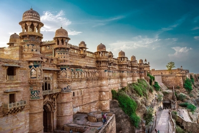
GWALIOR FORT, MADHYA PRADESH: One of India’s oldest, it is located atop the hilltop in Gwalior. During the Mughal rule, it was used as a prison and was continuously occupied by one ruler or the other until the British rule. A stone inscription found inside the temple is proof of the second oldest record of the numeric zero (0) symbol.

KANGRA FORT, HIMACHAL PRADESH: Nestled in the hills of Kangra, around 20 kilometres from Dharamshala, in Himachal Pradesh, this fort was built by the Kangra State’s Rajput family. The Fort, which has stood witness to many rulers, including the British, was destroyed by an earthquake in 1905. However, it still remains a popular tourist destination.

CHITRADURGA FORT, KARNATAKA:  It was built in stages between the 11th and 13th centuries by rulers, including the Chalukyas and Hoysalas, and later, the Nayakas of Chitradurga of the Vijayanagar Empire. It was taken by Hyder Ali in 1779, captured by British forces, only to be later reclaimed by Hyder Ali’s son, Tipu Sultan.

Picture Credit : Google 

WHAT IS WETLANDS?

An area of land that is either covered by water or saturated with water, wetlands are those areas where water covers the soil. While most scientists consider swamps, bogs, and marshes to be the three main kinds of wetlands, there are other types like peatlands, sloughs, and mires as well. Even though wetlands were seen as wastelands for most of history as they don’t support development, it has since been realised that these are among the most valuable ecosystems on Earth. Governments began recognising the value of wetlands from the 1970s and laws have been put in place in parts of the world to protect wetlands.

Categories of Wetlands

Wetlands vary widely because of regional and local differences in soils, topography, climate, hydrology, water chemistry, vegetation and other factors, including human disturbance. Indeed, wetlands are found from the tundra to the tropics and on every continent except Antarctica. Two general categories of wetlands are recognized: coastal or tidal wetlands and inland or non-tidal wetlands.

Coastal/Tidal Wetlands

Coastal/tidal wetlands in the United States, as their name suggests, are found along the Atlantic, Pacific, Alaskan and Gulf coasts. They are closely linked to our nation’s estuaries where sea water mixes with fresh water to form an environment of varying salinities. The salt water and the fluctuating water levels (due to tidal action) combine to create a rather difficult environment for most plants. Consequently, many shallow coastal areas are unvegetated mud flats or sand flats. Some plants, however, have successfully adapted to this environment. Certain grasses and grasslike plants that adapt to the saline conditions form the tidal salt marshes that are found along the Atlantic, Gulf, and Pacific coasts. Mangrove swamps, with salt-loving shrubs or trees, are common in tropical climates, such as in southern Florida and Puerto Rico. Some tidal freshwater wetlands form beyond the upper edges of tidal salt marshes where the influence of salt water ends.

Inland/Non-tidal Wetlands

Inland/non-tidal wetlands are most common on floodplains along rivers and streams (riparian wetlands), in isolated depressions surrounded by dry land (for example, playas, basins and “potholes”), along the margins of lakes and ponds, and in other low-lying areas where the groundwater intercepts the soil surface or where precipitation sufficiently saturates the soil (vernal pools and bogs). Inland wetlands include marshes and wet meadows dominated by herbaceous plants, swamps dominated by shrubs, and wooded swamps dominated by trees. Certain types of inland wetlands are common to particular regions of the country.

Many of these wetlands are seasonal (they are dry one or more seasons every year), and, particularly in the arid and semiarid West, may be wet only periodically. The quantity of water present and the timing of its presence in part determine the functions of a wetland and its role in the environment. Even wetlands that appear dry at times for significant parts of the year — such as vernal pools– often provide critical habitat for wildlife adapted to breeding exclusively in these areas.

Credit : EPA 

Picture Credit : Google 

WHAT IS THE TUNDRA?

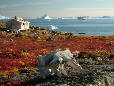
The tundra refers to a vast, flat, treeless Arctic region of Europe, Asia, and North America in which the subsoil is permanently frozen. Tundra ecosystems are also found on the mountaintops here, where the climate is cold and windy, and rainfall is scant. These lands are covered with snow for much of the year, which melts during the summer. Yet it hosts a few species of wildlife acclimatised to harsh conditions. As the tundra faces the threat of global warming, so do its inhabitants.

Plants and Animals in Tundras:

Mountain goats, sheep, marmots, and birds live in mountain—or alpine—tundra and feed on the low-lying plants and insects. Hardy flora like cushion plants survive in the mountain zones by growing in rock depressions, where it is warmer and they are sheltered from the wind.

The Arctic tundra, where the average temperature is -34 to -6 degrees Celsius (-30 to 20 degrees Fahrenheit), supports a variety of animal species, including Arctic foxes (Vulpes lagopus), polar bears (Ursus maritimus), gray wolves (Canis lupus), caribou (Rangifer tarandus), snow geese (Anser caerulescens), and musk oxen (Ovibos moschatus). The summer growing season is just 50 to 60 days, when the sun shines up to 24 hours a day.

The relatively few species of plants and animals that live in the harsh conditions of the tundra are essentially clinging to life. They are highly vulnerable to environmental stresses like reduced snow cover and warmer temperatures brought on by global warming.

Climate Change Impact on Tundras

The Arctic tundra is changing dramatically due to global warming, a term that falls within a wider range of trends scientists now prefer to call climate change. The impacts in this region are broad and somewhat unpredictable. Animals that are typically found farther south, like the red fox (Vulpes vulpes), are moving north onto the tundra. This means the red fox is now competing with the Arctic fox for food and territory, and the long-term impact on the sensitive Arctic fox is unknown.

Other tundra denizens, such as the wolf spider (Lycosidae spp.), are growing bigger and thriving. Shrubs are getting taller, contributing to declines in the sensitive groups of lichen that caribou and other species depend on for food. Lakes and ponds are evaporating or draining away.

Ctedit : National geographic society 

Picture Credit : Google 

WHAT IS PELAGIC ZONE?

The pelagic zone is the open region of any lake, sea, or ocean that is away from any part of land, be it the coast or the sea floor. Marine life-from microscopic plankton and tuna to sharks – dominates this area. Due to the abundance of marine creatures, it is a critical space for producing oxygen, regulating climate, and economic activity.

Pelagic Zone Facts

The pelagic zone plays many critical roles that make it essential to life on Earth. Factors that make the pelagic zone unique include:

It covers more than 50% of the Earth in water, more than 3.2 kilometers (2 miles) deep.
It makes up more than 99% of the inhabitable space on our planet.
The deepest part of the ocean, the Mariana Trench, is about 11,000 meters (7 miles) deep.
The open ocean produces more than 50% of the world’s oxygen.
It is a critical carbon sink, storing 50 times more carbon dioxide than the atmosphere.
Many of its inhabitants never experience sunlight.

The open ocean provides food, medicine, and economic opportunities for people worldwide. In addition to seafood, ocean harvests provide ingredients for foods like peanut butter and soy milk. Medications for Alzheimer’s disease, cancer, heart disease, and arthritis use materials extracted from the ocean, and the United States alone produces $282 billion in ocean-dependent goods and services.

Layers of the Pelagic Zone

The pelagic realm is divided into five distinct regions based on average depth and sunlight availability. Moving from the surface to the ocean floor, the zones are labeled:

Epipelagic
Mesopelagic
Bathypelagic
Abyssopelagic
Hadopelagic

Sunlight, oxygen, and temperature decrease with depth while pressure increases. The organisms in each zone have adapted to live in these conditions.

Credit : Study.com

Pucture Credit : Google