From finding the fastest path to a cafe to self-driving cars, modern necessities and benefits rely upon something that many take for granted: the Global Positioning System (GPS). GPS is so deeply ingrained into our daily lives that it’s difficult to picture a world without it, but did you know where it came from?
The origin of GPS
In the middle of the 1960s, the US Navy experimented with satellite navigation to follow U.S. submarines that were carrying nuclear weapons. The Department of Defence (DOD) decided to employ satellites to support their scheduled navigation system in the early 1970s because they wanted to make sure that it was a reliable, stable system, based on previous ideas from navy scientists. In 1978, the Department of Defence launched the first Navigation System with Timing and Ranging (NAVSTAR) satellite which later changed into GPS. In 1993, the 24-satellite constellation went into full functioning. It was initially intended to replace earlier navigation systems and locate military transportation equipment worldwide with accuracy. Over time, the GPS evolved into an easily available, free device that improves daily safety and comfort together
The Pioneers behind GPS
Despite being created by the U.S. Department of Defence, a few scientists have been recognized as having made significant contributions to this ground-breaking technology. Roger L. Easton led the Space Application division of the Naval Research Laboratory. Timing technology and circular orbits are two of the most important aspects of GPS that he specialised in as a Cold War scientist. As the first manager of the Navstar GPS programme, Brad Parkinson contributed to the program’s conception and early to mid-stage implementation. Dr. Ivan Getting was the founding president of The Aerospace Corporation and drove the GPS’s launch. To pinpoint their precise location, Dr. Gladys West first worked at the U.S. Naval Weapons Laboratory, where she calculated equations and analyzed satellite data.
How Does GPS Work?
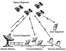
Satellites, ground stations, and receivers make up the three components of the GPS. 13 satellites transmit radio signals that provide precise time and location derived from onboard atomic clocks. At a speed of 300,000 kilometres per second or the speed of light, these signals travel across space. The precise location of these satellites is verified by ground stations by receiving their signals. A computer, an atomic clock, and a radio are installed on every satellite. It continuously sends its position and time shifts since it recognizes the Earth’s orbit and the clock. The scientific use of the GPS is offering historically beyond-reach data in exceptional amounts and with extraordinary clarity. The movement of the polar ice sheets, the tectonic plates of Earth, and volcanic activity are all being measured by scientists using GPS. Ever wondered how birds find their way?
If you were lost in the middle of the woods and couldn’t see the sun, you might use a compass to figure out which way to go. For more than a thousand years, people have used magnetic compasses to navigate. But how do the other birds find their way?
The Earth’s magnetic field is recognized for shielding the planet and its people from risky cosmic rays and plasma emitted by the sun. However, birds use this magnetic field for navigation in a unique manner, similar to a GPS, and they can turn it on and off with great flexibility. Researchers have discovered two factors that are essential to a bird’s internal GPS: eyesight and scent. The perfume is unusual because we don’t typically associate birds with a sense of smell. The scent, it turns out, plays an important role in helping birds navigate. A bird can identify magnetic fields visually, allowing it to use a visual compass to navigate over long distances. Scientists have discovered a protein called cryptochromes in their retinas that enables signalling and sensing activities, assisting birds in navigating the great distances they travel while migrating.
Researchers detected a little magnetite area on the beaks of several birds. Magnetite is a magnetised rock that functions as a miniature GPS device for birds, providing information about its position relative to the Earth’s poles. Birds are considered to be able to navigate vast distances across places with few landmarks, such as the ocean, by using both beak magnetite and eye sensors.
Picture: Credit Google

