Category People and places

WHICH ARE THE FABULOUS FORTS IN INDIA?

Standing tall as proof of a glorious past and skilled craftsmanship, here are some majestic forts that are steeped in historical and architectural importance.

AMER FORT, RAJASTHAN: Located in Amber, 11 kilometres north-east of Jaipur, the Amer or Amber Fort was the capital of the Kachhawa Rajputs before Jaipur was built. Built by Raja Man Singh sometime in the 17th Century, the most beautiful palace within the Fort is the Sheesh Mahal or the Palace of Mirrors.

AGRA FORT, UTTAR PRADESH: Constructed during 1565-1573 for Mughal Emperor Akbar, this magnificent fort was also known as the “Lal-Qila”, “Fort Rouge” or “Qila-i-Akbari”. It is among the first sites to be declared a UNESCO World Heritage Site in 1983.

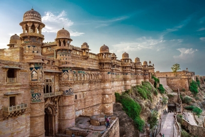
GWALIOR FORT, MADHYA PRADESH: One of India’s oldest, it is located atop the hilltop in Gwalior. During the Mughal rule, it was used as a prison and was continuously occupied by one ruler or the other until the British rule. A stone inscription found inside the temple is proof of the second oldest record of the numeric zero (0) symbol.

KANGRA FORT, HIMACHAL PRADESH: Nestled in the hills of Kangra, around 20 kilometres from Dharamshala, in Himachal Pradesh, this fort was built by the Kangra State’s Rajput family. The Fort, which has stood witness to many rulers, including the British, was destroyed by an earthquake in 1905. However, it still remains a popular tourist destination.

CHITRADURGA FORT, KARNATAKA:  It was built in stages between the 11th and 13th centuries by rulers, including the Chalukyas and Hoysalas, and later, the Nayakas of Chitradurga of the Vijayanagar Empire. It was taken by Hyder Ali in 1779, captured by British forces, only to be later reclaimed by Hyder Ali’s son, Tipu Sultan.

Picture Credit : Google 

WHAT IS SPECIAL ABOUT CANADA’S MIGUASHA NATIONAL PARK?

Canada’s Miguasha National Park is a treasure trove of natural history, as it holds within  it priceless fossils that educate us about what was in the world millions of years ago.

Spanning more than 215 acres, the Miguasha National Park is located on the southern coast of the Gaspe peninsula in Quebec, Canada. Unlike most parks around the world, this Park is not popular for its animals, plants, birds, reptiles, amphibians, insects, or marine creatures living today. However, it is an extremely important region to trace the history of the planet’s wildlife as we know it, thanks to the fossils in this area.

On the shore of the peninsula are remarkably well-preserved fossil beds from the Devonian period (see box), from millions of years ago. From vertebrates and invertebrates (such as lobe-finned fishes) to plants, algae, and several microorganisms, the astonishing biodiversity of these fossils offers scientists much more than just a glimpse of Devonian life. Even though there are more than 50 Devonian period fossil sites across the globe, “none matches Miguasha in abundance of specimens, quality of fossil preservation and representation of evolutionary events for vertebrates”.

Discovered in 1842, the site has been of great scientific interest and significance the world over, and fossil specimens from the location were sent to museums and universities for studies. In 1999, the Park was declared a UNESCO World Heritage Site, and is considered “the world’s most outstanding illustration of the Devonian Period”.

Past  forward

The most important contribution of the Miguasha National Park to the study of evolution is through the largest number of and best-preserved fossil specimens of the lobe-finned fish that gave rise to the first four-legged. air-breathing, terrestrial vertebrates the tetrapods

Among the fossils that made Miguasha popular are 21 species of fish fossils. And the most significant among them? The Eusthenopteron foordi- the extinct lobe-finned fish fossil. It is this creature’s “limblike fins and two-way gills-and-lungs respiratory system that led to the present understanding of evolution from fish to four-limbed, land-dwelling vertebrates”. And not surprisingly, this specimen has been named “the Prince of Miguasha”!

Good news but…

According to the International Union for Conservation of Nature, the conservation outlook for this site has been assessed as “good” in the latest assessment cycle (2020).

In fact rigorous and continuous fieldwork and research initiatives have resulted in the discovery of new fossils and resultant inferences on how Devonian fishes and tetrapods evolved over a period of time. Though fossil sites have the potential to be disturbed or damaged by human activity, this site is “secure and well protected”. “Overall site management and protection can be rated as mostly or highly effective.”

In addition to the research initiatives. the educational outreach programmes and “interpretive facilities for visitors” too have been impressive enough to create awareness.

Picture Credit : Google 

Where is Ukraine located?

Ukraine is located in Eastern Europe, sharing its borders with Russia, Belarus, Moldova, Romania, Hungary, Slovakia and Poland.

Covering an area of 600,000 square kms, Ukraine is the second largest country in Europe, next only to Russia. It is roughly twice as big as Italy. The landscape of Ukraine is mostly plains and plateaus, with only the Carpathian Mountains in the west rising to impressive heights.

Ukraine has a population 41.3 million people, and the language spoken is mainly Ukrainian; Russian is also spoken by many people. Its capital is Kyiv.

The country is one of the largest grain exporters in the world, blessed with large areas of fertile land. But it is still counted as one of the poorer countries of Europe, haunted by low life expectancy and widespread corruption.

Picture Credit : Google

Why is Kyiv a unique city?

The impressive capital of Ukraine, Kyiv boasts of a rich, ancient history. According to legends, this port city on the Dnieper River was founded by three brothers named Kyi, Shchek and Khoryv, and their sister Lybid.

The city-name Kyiv means ‘belonging to Kyi’. It acquired the title ‘Mother of Rus Cities’, a thousand years ago, as the centre of Kievan Rus. The city suffered heavy damages during World War II, but it was rebuilt and restored by the mid-1950’s. The second half the 20th century saw Kyiv flourishing with a well-developed economy and cultural life.

Ukraine became independent from the Soviet Union in 1991, and this enhanced the status of Kyiv as a major capital city in Europe.

The city has many higher education centres and hi-tech industries. There are famous historical landmarks, too, like the Saint Sophia Cathedral and Golden Gates of Kyiv.

Picture Credit : Google

What made the U.S.S.R special?

The birth of a new order in Russia was not just something that happened within the borders of that country: it affected the whole world and redrew the world map.

In 1922, Russia signed a treaty along with its neighbouring countries Ukraine, Belarus, Georgia, Azerbaijan and Armenia and formed the Soviet Socialist Republics, chaired by Lenin. The organisation then grew to include 15 Soviet Republics, forming a mammoth nation with a long name, the Union of the Soviet Socialist Republics (U.S.S.R). It was nothing like the world had ever seen. The world’s first and biggest communist state, it stood up against the capitalist West as the face of Communism.

The U.S.S.R was totally controlled by the Communist Party. The largest country while it existed, it was spread across more than 22.4 million square kilometres and covered a distance of 10,900 kilometres from the Baltic Sea in the west to the Pacific Ocean in the east. More than a hundred distinct nationalities were included in the USSR, the majority of the population made up of East Slavs. Its capital was Moscow and the official language, Russian. It also had other languages like Ukrainian, Georgian, Kasakh, Armenian and Azerbaijani. The USSR was an atheistic nation and owed no allegiance to any religion.

Picture Credit : Google

Why is Siberia special?

Since the 17th century, Siberia has been a part of modern Russia. Siberia’s territory extends eastwards from the Ural Mountains to the watershed between the Pacific and Arctic drainage basins. Siberia is divided into the Western and the Eastern Siberia, by the Yenisei River. Siberia stretches southwards from the Arctic Ocean to the hills of north-central Kazakhstan and to the northern parts of Mongolia and China. Siberia’s western part consists of some territories of the Ural region and the far eastern part has been historically called the Russian Far East.

Siberia is renowned globally for its long, harsh winters, with a January average of – 25 °C. Even though it is geographically situated in Asia, due to it being colonized and incorporated into Russia, it is culturally and politically a part of Europe. Some scholars say the word “Siberia” is derived from the Mongolian word ‘Shaver’ (meaning swamp), while some others connect the word with the name of “Sabirs” – the people who once inhabited the steppes of Western Siberia. The spreading of the name for the entire territory of Siberia happened due to the Russian advance in the 17th century.

The area of Siberia is 12.6 million square kilometres, which is 74 per cent of the whole territory of Russia. Can you imagine what this is like? It is almost 25 times the area of France!

Siberia is also home to the largest swamp in the world – the Vasyugan swamp. It is 20 per cent wider than the whole of Switzerland and it has more than 800 lakes within its limits. This swamp also contains the world’s largest deposits of peat. Apart from this, Siberia is home to Lake Baikal as well.

Picture Credit : Google