Category Rivers

HOW DO WATERFALLS FORM?

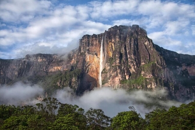
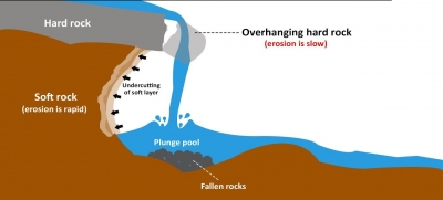
A waterfall develops when the bed of the river changes from hard to soft rock. As the force of the water wears away soft rock faster, the level of the softer riverbed drops, and the river plunges over a ledge of hard rock. The depth of the fall increases over time as more and more of the soft rock is washed away.

A waterfall is a river or a body of water that steeply falls over a rocky edge into a plunge pool. These are also called cascades.

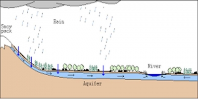
Erosion is the process of wearing away the earth. It plays an important part in the formation of waterfalls. Waterfalls also contribute to erosion.

The process of formation of waterfalls happens when a stream flows from soft rock to hard rock. This happens both laterally and vertically. In every case the soft rock erodes and leaves the hard rock as it is. Over this a stream falls.

The fall line is an imaginary line along which parallel rivers plunge while flowing from uplands to low lands. Many waterfalls in this way help the geologists determine a region’s fall line and underlying rock structure.

As the stream flows it carries various amounts of sediments- be it microscopic silt, pebbles or boulders. Sediments erode the beds of soft rocks like sandstone or limestone. The stream then cuts the beds so deep that only hard rocks like granite are left.

Credit: jagranjosh.com

Picture Credit : Google

HOW DO RIVERS KEEP FLOWING?

Rivers are kept running by the addition of water from rainfall or melting snow. Even when it does not rain, underground reservoirs (water stores) keep rivers supplied with water and flowing. When it rains, a lot of water seeps and sinks into the ground to surface somewhere else as a spring. Over thousands of years, rivers can carve huge valleys out of solid rock with a wide floodplain, which is a flat area that catches the overflow when the river is full.

Rivers keep flowing because gravity is constantly pulling the water down the path of least resistance (downhill). A river flows because there is a water table to support it. A river is nothing more than an outward manifestation of the water table.

A river that does not run dry at any time of year is carrying surplus water from precipitation that collects in the permeable rocks of hills and mountains that surround the watershed. Most rivers get their water from the mountains, where there is far more precipitation than over the lowlands.

Credit: SidmartinBio

Picture Credit : Google

WHICH IS THE HIGHEST WATERFALL?

Angel Falls or Salto Ángel (indigenous name: Kerepakupay Vená) is the world’s highest free-falling waterfall at 3,212 feet with an uninterrupted drop of 2,648 feet lying in the Canaima National Park, Venezuela. It is situated on the Churún River, an affluent of the Carrao. Curún in indigenous Pemón language means “thunder.”

Angel Falls is located in the Guayana highlands, one of the five topographical regions of Venezuela. It plunges off the edge of a tepui, or table-top mountain, called Auyan Tepui (“Devils Mountain”). It is 500 feet wide at its base and in total is 15 times higher than America’s Niagara Falls Angel Falls in Venezuela, which plunge 979 m vertically.

Angel Falls is one of Venezuela’s top tourist attractions, despite its remoteness and the absence of roads leading to nearby villages. One of the world’s great natural wonders, Angel Falls inspires feelings of awe in the hearts of those who make the journey.

Although sighted in the early twentieth century by the explorer Ernesto Sanchez La Cruz, the waterfall was not known to the Western world until it was visited in 1935 by the American aviator, James Crawford Angel, on a flight while searching for a valuable ore bed. In 1936, he returned and landed his plane at the top of the waterfall. The falls are currently named “Angel Falls” after him; interestingly, the indigenous name for the falls means “Devil’s Mouth.”

Credit: NEW WORLD ENCYCLOPEDIA.

Picture Credit : Google

WHICH IS THE WORLD’S LONGEST RIVER?

Flowing northward through the tropical climate of eastern Africa and into the Mediterranean Sea, the Nile river is the longest river in the world at 4,135 miles (6,650 kilometers), according to the U.S. National Park Service.

The Nile runs through Egypt, as well as nine other African nations Sudan, Eritrea, Ethiopia, Uganda, Kenya, Tanzania, Rwanda, Burundi and the Democratic Republic of Congo. More than 300 million people depend on the Nile for their water supply and the irrigation of seasonal crops, according to the Council of Ministers of Water Affairs of the Nile Basin.

The Nile’s energy is harnessed by the Aswan High Dam, which was completed in 1970 and provides hydroelectricity and controls summer flooding. During the 1980s, the dam provided half of Egypt’s electricity, although that amount has decreased over the years and it currently contributes 20 percent of total energy generated in Egypt, according to NASA’s Earth Observatory.

Credit: LIVESCIENCE

Picture Credit : Google

WHAT IS A DELTA?

As a river reaches the sea or a lake and slows down, sediment- sand, silt and mud – builds up at its mouth, blocking its flow. The river then breaks up into several individual strands of water that make their way to the larger water body. The Nile forms a classic delta formation as the river enters into the Mediterranean Sea.

One of the first texts to describe deltas was History, written during the 5th century BCE by Greek historian Herodotus. In that work, Herodotus mentioned that the Ionian people used the term delta to describe the low-lying region of the Nile River in Egypt. During a visit to the region, Herodotus also recognized that the land bounded by the seaward-diverging distributary branches of the Nile and the sea was deltoid in shape; he is often given credit for first using the Greek letter ? (delta) to describe it. Although many of the world’s deltas are deltoid, or triangular, in shape, notable exceptions exist. In most cases, the delta shape is controlled by the outline of the water body being filled by sediments. For this reason, the term delta is now normally applied, without reference to shape, to the exposed and submerged plain formed by a river at its mouth.

Deltas have been important to humankind since prehistoric times. Sands, silts, and clays deposited by floodwaters were extremely productive agriculturally; and major civilizations flourished in the deltaic plains of the Nile and Tigris-Euphrates rivers. In recent years geologists have discovered that much of the world’s petroleum resources are found in ancient deltaic rocks.

Deltas display much variation in size, structure, composition, and origin. These differences result from sediment deposition taking place in a wide range of settings. Numerous factors influence the character of a delta, the most important of which are: climatic conditions, geologic setting and sediment sources in the drainage basin, tectonic stability, river slope and flooding characteristics, intensities of depositional and erosional processes, and tidal range and offshore energy conditions. Combinations of these factors and time give rise to the wide variety of modern deltas. The presence of a delta represents the continuing ability of rivers to deposit stream-borne sediments more rapidly than they can be removed by waves and ocean currents. Deltas typically consist of three components. The most landward section is called the upper delta plain, the middle one the lower delta plain, and the third the subaqueous delta, which lies seaward of the shoreline and forms below sea level.

Credit: Britannica

Picture Credit : Google

WHERE DO RIVERS START AND END?

Rivers start off as small springs and streams high in the mountains. As they tumble downhill, they are joined by other streams, called tributaries, and become broader as they flow further. Upon reaching flat plains, they flow smoothly and deeply until they empty their waters into the sea or a lake.

Most rivers begin their life high up in the mountains and hills of the world. There are heavy downpours of rain here and perhaps melting snow. Some of the rain soaks into the ground and the rest runs over the surface, collects in pools, then trickles downhill with the force of gravity. Small streams are formed, which get bigger as they collect more water and join up with other streams. The ever-increasing stream wears away the ground as it goes, carving out valleys and shaping the landscape. The speed of the flowing water and the hardness of the ground have an effect on the shape created. The ‘wearing away’ is called erosion.

A mountain stream is sometimes called a youthful river and it is fast flowing, making deep valleys with steep sides. Once it begins to cut a valley it is trapped in it and will continue to carve out the same valley for perhaps thousands of years. As it tumbles downhill, the stream collects and carries rocks, stones and pebbles along with it. Progressing on its journey towards the sea, it collects more and more water until it is big enough to be called a river. Eventually, the land becomes flatter and the water flow slows down, causing the river to drop its stones and pebbles onto the river bed. This is called deposition. As an ‘old river’ meanders slowly through flat land (a bend in a river is called a meander), it is carrying only mud.

Eventually a river meets the sea and the place where it does is called the mouth. The last of the mud is deposited at the river’s mouth. A wide mouth is called an estuary. Some estuaries are enormous – the estuary of the Amazon is 333 kilometres wide!

Sometimes a lowland river winds so much that the looping meanders almost touch. The river may eventually erode away the narrow area of land between two loops so that its course runs straight and a horseshoe-shaped area of water is stranded – an ox-bow lake.

Credit: Young People’s Trust for the Environment (YPTE) 

Picture Credit : Google