Category Geography

What is the basic information about Libya country?

Though Libya’s economic future changed with the discovery of petroleum in the late 1950s, today it faces political turmoil.

Ranu Joardar

Libya is an oil-rich desert country, which in the past couple of years has become an important crossover for migrants intending to reach Europe. It is currently ranked 92 among the major economies. Let us know more about this North African country.

History

Historically, Libya was never heavily populated or a power centre. Before the discovery of oil in the late 1950s, the country was seen as poor in natural resources. It was mostly dependent upon foreign aid and imports for the maintenance of its economy.

The discovery of petroleum changed the fate of Libya. The country’s first productive oil well was struck in 1959 at Amal and Zelten, now known as Nasser. The country began exporting oil in 1961.

The first settlers of Libya were the Berbers during the Late Bronze Age, around 1200 BC. The land was then home to the Phoenicians (an ancient Mediterranean civilisation). They established coastal trading posts in the 7th Century BC

The name ‘Libya’ was given by the Greeks when they occupied the eastern part of the country. The country was also once part of the Roman empire.

Around 700 AD, the Arabs came and introduced Islam to the area. From the 16th Century, the country was under the Ottoman Empire until Italy conquered it in 1912. The French and British took over Libya during the Second World War in 1943.

Libya finally gained its independence in 1951. However, it was ruled by monarchs till 1969 when Colonel Muammar Gaddafi overthrew King Idris I.

Gaddafi controlled Libya until the 2011 revolution when he was killed. Despite achieving independence from autocratic rule, the country continues to rebuild its government.

Geography

The fourth-largest country in Africa is mostly a desert and most of its population lives along the coast and its immediate hinterland (region lying inland from a coast). The de facto capital, Tripoli, and Benghazi (second-largest city) are on the coast of the Mediterranean Sea.

Libya is surrounded by the Mediterranean Sea, Tunisia, Algeria, Niger, Chad, Sudan, and Egypt. As the country is part of the Sahara desert (the world’s largest hot desert), the country has no permanent rivers.

To access the water below the desert, the Great Man-Made River was constructed to deliver fresh water to the cities through a network of underground pipelines.

Flora and fauna

As the country’s coastal plains have high precipitation, these regions are home to herbaceous vegetation and annual grasses such as asphodel (a herb of the lily family).

The north of Akhdar mountains is covered with a dense forest of juniper and lentisc. Though the semiarid regions lack vegetation, the most commonly found plants here include saltwort (a plant used in making soda ash), spurge flax (a shrubby plant), goosefoot.

Asida is a popular traditional dish served in Libya during celebrations such as births or Eid. Wormwood, and asphodel.

The country is home to wild animals like desert rodents (desert hare and the jerboa), hyenas, foxes (fennec and the red fox), jackals, skunks, gazelles, and wildcats. Its largest national park, El Kouf National Park, is known for its sand dunes, wetlands, and hilly terrain.

The country’s native birds include wild ringdove, partridge, lark, and prairie hen.

People

About 97% of the country’s population consists of the Berber and Arab ethnic groups. Most Libyans speak Arabic, which is the country’s official language. At the beginning of the 21st Century, the country saw a rise in the number of foreign migrant workers, mainly from sub-Saharan African countries. About 25% population live either in Tripoli or Benghazi and the rest live near desert oases, where they can access water.

The country is famous for its weaving, embroidery, and metal engraving. Traditional Libyan food is a blend of North African.  Berber,  and Mediterranean cuisines. Couscous, lamb, dates, and olives feature heavily in the Libyan cuisine

Politics

Following independence, Libya was ruled by monarchs. After overthrowing King Idris I in 1969 and suspending the constitution in a military coup, the country turned into an authoritarian state. Till 1977, Libya was ruled by a 12-member Revolutionary Command Council (RCC) with Colonel Gaddafi as secretary-general. Though he resigned from the post in 1979, he continued to be the de facto ruler of the country and head of the revolution until he was killed during the 2011 revolution.

Since 2014, the country has had competing political and military factions fighting for power. Though the two sides signed a permanent ceasefire in 2020, political rivalries continue leaving the country in a turmoil. Currently, the Prime Minister of Libya is Abdul Hamid Dbeibeh, leader of the Government of National Unity (GNU).

Libya Revolt of 2011

On February 15, 2011, anti-government protests were held in Benghazi after the arrest of human rights lawyer Fethi Tarbel. The protesters demanded the resignation of Gaddafi and the release of political prisoners. The protests gained momentum despite the Libyan security forces using lethal force against demonstrators. Soon, international pressure for Gaddafi to step down increased and sanctions against the regime were imposed by the UN Security Council. On October 20, Gaddafi was killed by rebel fighters in his hometown.

Picture Credit : Google 

Is the color of the oceans changing?

The color of over 56 per cent of the worlits oceans larger than Earths total laut eganse, has changed significantly over the last two decades and human-caused dimate change is likely the driver, according to researchers

These colour changes, subtle to the human eye, cannot be explained by natural, year-to-year variability alone. Ocean colour, a literal reflection of the life and materials in its waters, in regions near the equator was found to have steadily turned greener over time, indicating changes in the ecosystems within the surface oceans.

The green colour of the ocean waters comes from the green pigment chlorophyll present in phytoplankton. the plant-like microbes abundant in upper ocean Scientists are, therefore, keen to monitor phytoplankton to see their response to climate change

The researchers from the Massachusetts Institute of Technology (MIT), US, and other institutes in their paper published in the joumal Nature, say that it would take 30 years of tracking chlorophyll changes before climate-change-driven trends would show, because natural, annual variations in chlorophyll would overwhelm those influenced by human activities.

In a 2019 paper, study co-author Stephanie Dutkiewicz and her colleagues showed that monitoring other ocean colours whose annual variations are much smaller than those of chlorophyll, would convey mom dear signals of climate-change-driven changes and that they might even be apparent in 20 years, rather than 30.

“It’s worth looking at the whole spectrum, rather than just trying to estimate one number from bits of the spectrum.” said lead author B. B. Cael of the National Oceanography Center. Cael and team then statistically analysed all the seven ocean colours recorded by satellite observations from 2002 to 2022 together.

To understand climate changes contribution to all these changes, he used Dutkiewicz’s 2019 model to simulate the Earth’s oceans under two scenarios-one with greenhouse gases and the other without them. The greenhouse gas model predicted changes to the colour of about 50 per cent of the world’s surface oceans in under 20 years close to Cael’s conclusions from his real-world satellite data analysis. “This trend is consistent with anthropogenic climate change”

Picture Credit: google

How do crystals form?

Rocks are mixtures of different minerals. All minerals are crystals, but not all crystals are minerals. These solid substances are found naturally in the ground. But do we know how they are formed?

How do crystals form?

Scientifically speaking, the term “crystal” refers to any solid that has an ordered chemical structure. This means that its parts are arranged in a precisely ordered pattern, like bricks in a wall. The “bricks” can be cubes or more complex shapes. I’m an Earth scientist and a teacher, so I spend a lot of time thinking about minerals. These are solid substances that are found naturally in the ground and can’t be broken down further into different materials other than their constituent atoms. Rocks are mixtures of different minerals. All minerals are crystals, but not all crystals are minerals.

Most rock shops sell mineral crystals that occur in nature. One is pyrite, which is known as fool’s gold because it looks like real gold. Some shops also feature showy, human-made crystals such as bismuth, a natural element that forms crystals when it is melted and cooled.

Why and how crystals form

Crystals grow when molecules that are alike get close to each other and stick together, forming chemical bonds that act like Velcro between atoms. Mineral crystals cannot just start forming spontaneously – they need special conditions and a nucleation site to grow on. A nucleation site can be a rough edge of rock or a speck of dust that a molecule bumps into and sticks to, starting the crystallization chain reaction. At or near the Earth’s surface, many molecules are dissolved in water that flows through or over the ground. If there are enough molecules in the water that are alike, they will separate from the water as solids – a process called precipitation. If they have a nucleation site, they will stick to it and start to form crystals. Rock salt, which is actually a mineral called halite, grows this way. So does another mineral called travertine, which sometimes forms flat ledges in caves and around hot springs, where water causes chemical reactions between the rock and the air. You can make “salt stalactites” at home by growing salt crystals on a string. In this experiment, the string is the nucleation site. When you dissolve Epsom salts in water and lower a string into it, then leave it for several days, the water will slowly evaporate and leave the Epsom salts behind. As that happens, salt crystals precipitate out of the water and grow crystals on the string. Many places in the Earth’s crust are hot enough for rocks to melt into magma. As that magma cools down, mineral crystals grow from it, just like water freezing into ice cubes. These mineral crystals form at much higher temperatures than salt or travertine precipitating out of water.

What crystals can tell scientists

Earth scientists can learn a lot from different types of crystals. For example, the presence of certain mineral crystals in rocks can reveal the rocks’ age. This dating method is called geochronology – literally, measuring the age of materials from the Earth. One of the most valued mineral crystals for geochronologists is zircon, which is so durable that it quite literally stands the test of time. The oldest zircon ever found come from Australia and are about 4.3 billion years old – almost as old asour planet itself. Scientists use the chemical changes recorded within zircon as they grew as a reliable “clock” to figure out how old the rocks containing them are some crystals, including zircon, have growth rings, like the rings of a tree, that form when layers of molecules accumulate as the mineral grows. These rings can tell scientists all kinds of things about the environment in which they grew. For example, changesin pressure, temperature and magma composition can all result in growth rings. Sometimes mineral crystals grow as high pressure and temperatures within the Earth’s crust change rocks from one type to another in a process called metamorphism. This process causes the elements and chemical bonds in the rock to rearrange themselves into new crystal structures. Lots of spectacular crystals grow in this way, including garnet, kyanite and staurolite.

Amazing forms

When a mineral precipitates from water or crystallizes from magma, the more space it has to grow, the bigger it can become. There is a cave in Mexico full of giant gypsum crystals, some of which are 40 feet (12 meters) long – the size of telephone poles. Especially showy mineral crystals are also valuable as gemstones for jewellery once they are cut into new shapes and polished. The highest price ever paid for a gemstone was $71.2 million for the CTF Pink Star diamond, which went up for auction in 2017 and sold in less than five minutes. (The author works at University of Montana.) THE CONVERSATION

Picture credit : Google

WHAT ARE POLES OF INACCESSIBLILITY?

Every continent has a point hardest to reach from the coast of a landmass, either due to tough terrain or untraversable routes, or sheer distance from the coast. A pole of inaccessibility (not to be confused with the North and South Poles), is the point on any continent that is hardest to reach from the coast. There is one on every continent and a couple in the middle of the ocean! The Arctic pole of inaccessibility is a few hundred kilometres from the North Pole. Since there is no landmass so far north, the pole is calculated as the northernmost point that is furthest from land. Like the North Pole, it is located on the shifting pack ice of the northern Arctic Sea. The spot in Eurasia that is furthest from the ocean is located north of Ürümqi in northwest China, over 2,400km from the coast in the middle of desert. Both the North American an South American poles as well as the African pole are located near small towns. Two are in the midst of dense jungle and all three are over 1,760km from the nearest coast.  Australian’s remotest point is only 900 km from the nearest coast, in the northern Territory.

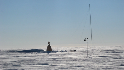
The Southern pole of inaccessibility (750 km from the South Pole) has a Russian research station built there in 1958. Also known as the Oceanic pole of inaccessibility, Point Nemo, in the South Pacific Ocean, is over 1,400 nautical miles from the three closest islands.

Picture Credit : Google

What is the process of sand formation and sand mining?

Most people think that sand is plentiful, but sand is a non-renewable resource. The demand for it actually exceeds supply and the rate at which we are using it, we will soon be running out of it. Let’s find out how sand is formed and about the effects of indiscriminate mining of sand on the environment.

Formation of sand

Sand is a naturally occurring granular material composed of finely divided rock and mineral particles. It is found on beaches and deserts. It is formed by the breaking down or erosion of large boulders by wind or water.

Sand is a very important mineral. It can be used to make concrete which is used in buildings to help support the structures. It is used to make glass, computer chips and to store nuclear waste. It can also be used as a mixer with salt to prevent the formation of ice on roads.

Sand mining

The extraction of sand is called sand mining. Sand can be mined from sand dunes, beaches and even dredged from river and ocean beds.

The main reason sand is extracted is to make concrete, which is in great demand because of the booming construction industry. River sand is considered the best for this purpose. It has jagged edges and is not rounded like desert sand. It also does not contain salt like beach sand. But since there isn’t enough sand on river beds, sand found on beaches and creeks is also used after removing the salt.

Harms the environment

Sand plays an important role in protecting the coastal environment. It acts as a buffer against strong tidal waves and storm surges by reducing their impact as they reach the shoreline.

Indiscriminate river bed mining harms the environment. It also leads to the deepening of rivers, change in the course of rivers and soil erosion. The river-plains become more vulnerable to flooding. Riverbed mining also affects groundwater recharge and the foundation of bridges, causing them to collapse.

When sand is taken away, all the life forms and biodiversity it supports also get destroyed. Indiscriminate beach and ocean mining have caused entire beaches and whole islands to disappear.

Where is sand mining rampant?

Illegal sand mining is rampant in developing countries like India and China, where construction is on the rise. Rich countries import sand from poor and developing countries. Singapore, for instance, is expanding its physical borders by importing sand from poorer countries like Cambodia, which, as a result is losing its beaches.

In India, mining licences are issued to contractors. The licences limit the quantities of sand that can be taken and the locations from where it can be mined. Sand mining policies are framed by state governments in India. Unfortunately, these laws are usually not enforced. There is hardly any monitoring either.

Serious crime

Markets for sand in India are dominated by sand mafias, criminal enterprises that mine and sell sand illegally. Although illegal sand mining is a serious environmental crime, there is little awareness about it. As it’s a rural issue, urban people are unaware of it unless they see it happening at a beach where they are holidaying. Also, many don’t want to register an official complaint against such illegal activities as it can be dangerous.

The UN took a long time to wake up to this issue’. The first-ever UNEP (United Nations Environment Programme) round-table on sand sustainability took place in October 2018 at Geneva, where I, as a keynote speaker, made a virtual presentation on the issue: A sustainable policy on sand trade should be a part of the political agenda of national governments everywhere.

Picture Credit : Google 

What is the long green belt initiative?

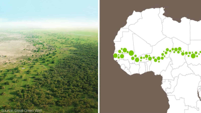
Have you heard about the Great Green Wall? The African-led initiative aims at restoring the continent’s degraded landscapes by creating an 8000-km-long belt of greenery across the Sahel, the region bordering the Sahara desert. Read on to find out interesting details about the project.

Regenerating the Sahel

The Sahara, the world’s largest hot desert located in North Africa, has expanded 10 per cent southwards into the Sahel since 1920.

The Sahel is a vast semi-arid region separating the Sahara from the tropical savanna grasslands to the south. It is mostly barren, with sandy, rock-strewn and degraded landscapes. It stretches from Senegal in the west to Eritrea in the east, and cuts through more than a dozen countries in between. It is also one of the world’s poorest regions.

The people who live in the Sahel are regularly beset by drought and famine. Overgrazing, increasing population and poor farming techniques have added to the problems.

Great Green Wall

In 2007, the African Union, made up of all 54 countries in the continent, decided to do something about regenerating the Sahel. It launched an ambitious project called the Great Green Wall, an 8000-km-long belt of greenery that would encircle the waist of Africa! The plan was to plant millions of trees across the Sahel to hold back the Sahara.

The Wall aimed to revitalise 100 million hectares (247 million acres) of degraded land, sequester 250 million tons of carbon, and create 10 million jobs in rural areas by 2030. Completed, it would be Earth’s most massive living structure. It was also expected to benefit the communities living in the Sahel and reduce conflict over land and migration due to drought.

It began with 11 countries, which later increased to 20, and then 26. In some countries, many of the planted trees died, either because they were not the suitable species for that region or because they were attacked by pests. Trees planted in remote, sparsely inhabited areas also perished. In many cases, the locals were not motivated enough and lost interest in looking after the trees. It turned out that constructing a wall of trees was not child’s play.

Indigenous methods of land use

The project leaders decided that each country would work according to its own plan and adapt indigenous methods of land use, such as soil conservation and rainwater harvesting that were already being followed by farmers and landowners. In some places, grasses and not trees were planted. In others, it was a mix of both. Hardy native species that were resistant to insects were chosen. For instance, the Sahel’s acacia trees became one of the staple plants. Its sap, called gum arabic, is used in a range of products, from paints and cosmetics to candies and sodas. The export of gum arabic became a steady source of income for the locals.

The project has had patchy success, depending on the country, its capacity to invest money and the enthusiasm of its farmers. Ethiopia began reforestation early and has so far planted more than 5 billion seedlings on 150,000 hectares of land. Burkina Faso, Nigeria, Niger, Senegal and Chad have also reforested large swathes of degraded land, planting trees numbering in the millions. Countries like Cameroon and Ghana were slower off the blocks.

Roughly 49 million acres were restored between 2007 and 2018 at a cost of more than $200 million. More than 20 million acres of land need to be restored every year and over $4 billion invested annually, if the Wall is to be finished by 2030.

However, the project has created more than 350,000 agroforestry jobs and generated $90 million in revenue in the countries where it has been implemented, giving them an incentive to soldier on.

INDIAN INITIATIVE

Africa’s Great Green Wall has inspired our own government to create a 1,400-km-long and 5-km-wide ‘green belt’ from Gujarat to the Delhi Haryana border, from Porbandar to Panipat. The plan hopes to reforest degraded land along the Aravalli Hills that will also act as a barrier to the shifting sands of the Thar Desert.

DID YOU KNOW?

* In 1996, 197 nations came together to ratify the United Nation’s Convention to Combat Desertification.

* More than 24 billion tons of fertile soil is still lost yearly to desertification, while 40 per cent of the Earth’s land surface is now considered degraded. Dry land degradation affects the economies of developing countries. The UN estimates that desertification impacts 3 billion people on Earth.

*Desertification cannot be blamed only on deserts! Similar to climate change, human activities are often the main cause of land degradation. Intensive agriculture, overgrazing by livestock, industries set up in remote areas, an exploding population and increasing urbanisation-all have led to desertification.

Picture Credit : Google