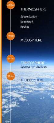
Category Earth Science

What conditions could help more parts of Earth host life?

Researchers find out an often overlooked key role played by the orbit of Jupiter on Earth.

Most planets have eccentric orbits. While circular orbits around a star would ensure that the distance between the star and the planet never changes, these eccentric orbits mean that the planets traverse around a star in an oval-shape. As a result, the planet would receive more heat when it goes closer to the star, affecting the planet’s climate.

Alternative solar system

Based on this knowledge and using detailed data from the solar system as we know it today, researchers from the University of California Riverside created an alternative solar system. In this hypothetical theoretical system, they were able to show that if Jupiter’s orbit were to become more eccentric, then it would lead to big changes in Earth’s orbit, thereby making the Earth more hospitable than it is currently.

This is because Jupiter in this theoretical system would push Earth’s orbit to be even more eccentric. As a result, parts of Earth would sometimes get closer to the sun. This would mean that even parts of Earth’s surface that are now sub-freezing will get warmer. In effect, the habitable range on the surface of the Earth would be increased.

Assumptions proven wrong

 The findings of this research, published in September in Astronomical Journal, go against two long-held scientific beliefs with respect to our solar system. One of these is that the current avatar of Earth is the best in terms of habitability. The second one is that changes to Jupiter’s orbit could only be bad for Earth.

Apart from upending these long-held assumptions, the researchers are looking to apply their findings in the search of exoplanets – habitable planets around other stars. While existing telescopes are adept at measuring a planet’s orbit, the same cannot be said about measuring a planet’s tilt towards or away from a star- another factor that could affect habitability.

The model developed in this research helps us better understand the impact of the biggest planet in our solar system, Jupiter, on Earth’s climate through time. Additionally, it also paves the way to find out how the movement of a giant planet is crucial in making predictions about habitability of planets in other systems.

Picture Credit : Google 

DO BACTERIA AND FUNGI SPEED UP WEATHERING?

When water collects in the cracks of a rock, it can freeze when temperatures drop. The ice expands and the pressure can split the rock. In cold, mountain regions, one can even hear gunshot-like cracks as rocks are split apart by frost.

A mechanical process, freeze-thaw weathering causes the ?joints?(cracks) in rocks to expand, which wedges parts of rocks apart. Because water expands by about 10% when it freezes, this creates outward pressure in rock joints, making the cracks larger.

Joints occur naturally in rocks as a result of their formation. Fractures that are not offset, joints do allow for the entry of water into rocks.

In climates where temperatures dip below freezing in the winter, moisture in the joints of rocks solidifies as ice. Over time, after several cycles of freezing and thawing, joints get large enough that bit of rock start to fall off in smaller pieces. This breakdown of rock happens faster at higher altitudes, where many freeze-thaw cycles can occur during the year.

Credit: Sciencing

Picture Credit : Google 

HOW DOES FROST BREAK UP ROCKS?

When water collects in the cracks of a rock, it can freeze when temperatures drop. The ice expands and the pressure can split the rock. In cold, mountain regions, one can even hear gunshot-like cracks as rocks are split apart by frost.

A mechanical process, freeze-thaw weathering causes the joints? (cracks) in rocks to expand, which wedges parts of rocks apart. Because water expands by about 10% when it freezes, this creates outward pressure in rock joints, making the cracks larger.

Joints occur naturally in rocks as a result of their formation. Fractures that are not offset, joints do allow for the entry of water into rocks.

In climates where temperatures dip below freezing in the winter, moisture in the joints of rocks solidifies as ice. Over time, after several cycles of freezing and thawing, joints get large enough that bit of rock start to fall off in smaller pieces. This breakdown of rock happens faster at higher altitudes, where many freeze-thaw cycles can occur during the year.

Credit: Sciencing

Picture Credit : Google 

What is the career in the field of Earth Sciences?

Our Earth is extremely fragile, and human activities are making it more vulnerable. One of the recent examples of the impact of indiscriminate development and climate change is the shocking collapse of a portion of the Nanda Devi glacier in Uttarakhand’s Chamoli district on February 7, 2021, and the ensuing floods that claimed many lives. The deadly disaster brings to light the need to rigorously study the impact of human activity on the environment. And that’s exactly what earth scientists do.

What is Earth Science?

Earth science is the study of the structure, composition, and evolution of the Earth, the life it supports, and the processes that govern the formation and behaviour of the Earth’s materials. It seeks to find answers to questions such as how ice moves, where the mineral resources are, and the rate of permafrost thaw. Understanding these phenomena is essential to the maintenance of life on the planet.

Different branches:

  • Glaciology: Glaciologists assess the impact of climate change, look for alternatives to sustain Earth’s depleting resources, and forecast avalanches.
  • Geology: Geologists study Earth and the processes that act on its materials. It also traces the history of the planet and its life forms since origin.
  • Hydrogeology: The study of water flow on and below the Earth’s surface and its chemistry.
  • Limnology: Limnology examines lake sediments to determine past climate and ecological environments.
  • Oceanography: The study of the ocean, including its water, boundaries and topography, types of currents, and marine biology.
  • Volcanology and Seismology: The scientific study of the dynamics of volcanoes and earthquakes.

What to study?

Universities in India and abroad offer a range of courses in Earth Sciences. You can pursue a Master of Science (M.Sc) and specialise in the field of your choice. A Ph.D is required to start working in the field.

Where: India

  • Wadia Institute of Himalayan Geology, Dehradun: Training and research programmes on Geomorphology and Environmental Geology. Geophysics, Petrology and Geochemistry
  • Indian Institute of Science Education and Research, Pune: Dual degree programme Bachelor of Science and Master of Science
  • Sharada University. Noida, and Pondicherry University: M.Sc in Environmental Sciences
  • Bharatiya Vidyapeeth, Insitute of Environment Education and Research. Punes M.Sc in Environment Science and Technology
  • Annamalai University, Cuddalore: M.Sc Earth Sciences and PG diplomas in Petroleum and Remote Sensing

Abroad

  • Utrecht University, the Netherlands, M.Sc Earth Surface and Water
  • University of Helsinki, Finland: M.Sc Geology and Geophysics
  • The University of Westent Australia: Master of Geographic Information Science
  • Massachusetts Institute of Technology, the U.S. M.SC Atmospheres, Oceans and Climate: M.Sc Geology, Geochemistry and Geobiology; Master of Environmental Policy and Planning

What are the job prospects?

Earth scientists primarily work in research organisations and environmental monitoring agencies.

These organisations could be in the private as well as the public sector.

Depending on your field of interest, you can also work with non-profit organisations and think-tanks on environment conservation and policy. If you have an academic bent of mind, then working in a university as a professor in the field of your choice could also suit you.


Picture Credit : Google

What is GPS map?

This accurate, up-to-date map is created using digital technology. You can view GPS maps on your phone, tablet, or computer. They can tell you exactly where you are at any time. The coordinates and position as well as atomic time obtained by a terrestrial GPS receiver from GPS satellites orbiting Earth interact together to provide the digital mapping programming with points of origin in addition to the destination points needed to calculate distance. This information is then analyzed and compiled to create a map that provides the easiest and most efficient way to reach a destination.

More technically speaking, the device operates in the following manner:

  • GPS receivers collect data from at least four GPS satellites orbiting the Earth, calculating position in three dimensions.
  • The GPS receiver then utilizes position to provide GPS coordinates, or exact points of latitudinal and longitudinal direction from GPS satellites.
  • The points, or coordinates, output an accurate range between approximately “10-20 meters” of the actual location.
  • The beginning point, entered via GPS coordinates, and the ending point, (address or coordinates) input by the user, are then entered into the digital mapping software.
  • The mapping software outputs a real-time visual representation of the route. The map then moves along the path of the driver.
  • If the driver drifts from the designated route, the navigation system will use the current coordinates to recalculate a route to the destination location.


Picture Credit : Google

What is political world map?

A political map shows you the countries of the world. You see where borders and cities are, including national capitals. Imaginary, numbered lines- the equator and lines of latitude and longitude – give you the exact position on Earth of places they pass through. Some of the largest independent nations in the world are the Russian Federation, People’s Republic of China, the United States of America, Canada, Australia, India, Brazil, Saudi Arabia, and Argentina. While the smallest nations include Vatican City, Monaco, Andorra, and Singapore.

As represented on the world map, some countries like Brazil, Australia, the USA, and Indonesia have long coastlines, while others are completely landlocked like Bhutan, Switzerland, Mongolia, and Lesotho.

The world political map shows dependent territories such as Greenland and the Faroe Islands of Denmark, as well as the French Overseas Territories, which are geographically and culturally distinct, enjoying some degree of autonomy but are not independent states.


Picture Credit : Google