Category Geology

WHAT ARE GEMSTONES?

Gemstones are made from rare crystals that have been cut up and polished. They are usually hard and clear, or colourful. Gemstones are extremely valuable because of their beauty and rarity. Usually when we think of gemstones we imagine a jeweller’s shop window, or a beautiful ring or necklace. Polished gemstones are set into jewellery and decorative objects.

Hard or clear crystals are not only used to make jewellery, they are also used in factories, spacecraft and lasers.

Natural gemstones are found in the Earth. Crystals in the Earth’s rocks are called minerals. Gems made from these minerals are called natural gemstones. Artificial gemstones are made from glass and from crystals made in laboratories and factories. Gems of all kinds are often made to imitate more valuable gemstones.

Picture Credit : Google

HOW DO GEMS ARE FORMED IN EARTH?

The Earth’s rocks are moving, squashing and often melting together. It is in this turmoil that gems are formed. The rocks are a mixture of minerals which are themselves made up of chemical elements. Atoms of chemical elements, such as carbon, oxygen and silicon, join up to make tiny building blocks. These fit together in neat regular patterns to form ‘crystals’.

Exactly what type and size of crystal forms depends on the chemical elements present, the temperature of them and the pressure exerted on them. Natural gems are found as clear or coloured crystals embedded in rock. They are also found as big crystals lining cracks or cavities in the Earth’s surface layer, or ‘crust’. Some gems are washed along by rivers and may then be picked out.

How gems are formed

Some gem crystals, like garnet, grow in solid rock as it squashes beneath moving mountains. Others, such as tourmaline, are formed in veins beneath the Earth’s surface.

Stones such as agate grow in volcanic rocks at the surface. Gems like ruby grow deep down where molten rock ‘cooks’ the Earth’s crust. Diamond crystals grow way down, around 160 km beneath the surface.

How can I make my career in the field of Geology? Do I have to take Science or Arts?

Geology is the study of the Earth, the materials it is made up of, the structure of the materials and the processes by which they change. To pursue a career in this field, you must have Physics, Chemistry and Mathematics in 10+2. After that you may go for graduation in Science (B.Sc.) followed by post-graduation in Geology. Or else, go for B.Tech. in Mining Engineering followed by M.Tech.

Geologists work in the areas of exploration and production, water supply, environmental engineering and geological surveying. Other areas include environmental planning, hydrogeology and pollution control. Employment is often found within the oil, gas and petroleum sector, the groundwater and construction companies.


Picture Credit : Google

What is GPS map?

This accurate, up-to-date map is created using digital technology. You can view GPS maps on your phone, tablet, or computer. They can tell you exactly where you are at any time. The coordinates and position as well as atomic time obtained by a terrestrial GPS receiver from GPS satellites orbiting Earth interact together to provide the digital mapping programming with points of origin in addition to the destination points needed to calculate distance. This information is then analyzed and compiled to create a map that provides the easiest and most efficient way to reach a destination.

More technically speaking, the device operates in the following manner:

  • GPS receivers collect data from at least four GPS satellites orbiting the Earth, calculating position in three dimensions.
  • The GPS receiver then utilizes position to provide GPS coordinates, or exact points of latitudinal and longitudinal direction from GPS satellites.
  • The points, or coordinates, output an accurate range between approximately “10-20 meters” of the actual location.
  • The beginning point, entered via GPS coordinates, and the ending point, (address or coordinates) input by the user, are then entered into the digital mapping software.
  • The mapping software outputs a real-time visual representation of the route. The map then moves along the path of the driver.
  • If the driver drifts from the designated route, the navigation system will use the current coordinates to recalculate a route to the destination location.


Picture Credit : Google

What is political world map?

A political map shows you the countries of the world. You see where borders and cities are, including national capitals. Imaginary, numbered lines- the equator and lines of latitude and longitude – give you the exact position on Earth of places they pass through. Some of the largest independent nations in the world are the Russian Federation, People’s Republic of China, the United States of America, Canada, Australia, India, Brazil, Saudi Arabia, and Argentina. While the smallest nations include Vatican City, Monaco, Andorra, and Singapore.

As represented on the world map, some countries like Brazil, Australia, the USA, and Indonesia have long coastlines, while others are completely landlocked like Bhutan, Switzerland, Mongolia, and Lesotho.

The world political map shows dependent territories such as Greenland and the Faroe Islands of Denmark, as well as the French Overseas Territories, which are geographically and culturally distinct, enjoying some degree of autonomy but are not independent states.


Picture Credit : Google

What is street map?

This type of map shows where the streets and roads in a town or city are. It will also show bus stops, stations, schools, hospitals, parks, and other useful and important places. The maps are of different sizes, shapes, and scales. Small maps are used to show the overview of a region’s major roads or routes while large maps give greater details and cover a large area. Highway maps give the overview of major routes within a region. Street maps mainly cover areas within a city or metropolitan area. A collection of road maps bound together in a book is referred to as road atlas. Road maps often use thin lines to indicate minor roads and thicker or bolder colors to indicate major roads.


Picture Credit : Google

What is physical map?

This type of map shows you the natural features in an area. These include mountains, volcanoes, rivers, lakes, seas, oceans, and deserts. Different colours and symbols are used to represent these features.

Continents:

The physical land mass of the world, the planet Earth, is divided into seven continents of Africa, North America, South America, Europe, Australia, Asia and Antarctica (It being the only uninhabited continent) . Asia with 29% of the world land mass is the largest and Australia with 5.9% of landmass the smallest. Mount Everest is the highest point on earth and Dead Sea the lowest.

Deserts:

Deserts occupy about 33% of the world land mass. Deserts, places on earth which have very little rainfall, can be either hot or cold. The largest cold deserts are the polar deserts of Antarctica and Arctic Circle. The largest sub tropical or hot deserts are the Sahara and Arabian Desert. Gobi and Kalahari are other large deserts.

Mountain ranges:

Mountains cover 24% of the earth land mass and are spread over all the continents. Asia has the largest area covered with mountains and Africa the least- only 3%. Himalayas, the Earth’s youngest mountains are also the highest. These mountains are still growing. Mount Everest at 8848 meters is the highest peak and K2 at 8611 meters, the second highest. Alps are the mountain ranges in Europe and Rockies in North America.

Oceans:

Over two-third of the Earth’s surface is covered with water and more than 97% of this water is contained in the oceans. The Pacific Ocean is the largest and deepest ocean in the world. The other oceans are Atlantic, Indian, Pacific, Southern and Arctic.

Lakes:

The earth is dotted with lakes-bodies of fresh or salt water surrounded by a land mass. Northern hemisphere has the majority of fresh water lakes. Aral Sea, Dead Sea, and Great Salt Lake are salt water lakes. Caspian Sea, if considered as a lake is the largest. Other large lakes are Lake Michigan in North America, Lake Victoria in Africa, and Lake Eyre in Australia.

Rivers:

Rivers are watercourses flowing towards oceans, seas, lakes or another river. The Nile River, in Africa, with a length of 6695 kilometers is the longest in the world. The Brahmaputra and the Ganges are rivers in Asia. The Colorado and the Mississippi are rivers in North America. The Amazon, the second largest river, is in South America. River Congo, in Africa is the deepest river though it is the ninth longest.


Picture Credit : Google

What are urban areas?

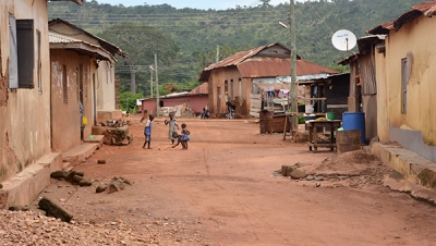
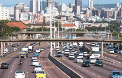
An urban area is the region surrounding a city. Most inhabitants of urban areas have non agricultural jobs. Urban areas are very developed, meaning there is a density of human structures such as houses, commercial buildings, roads, bridges, and railways.

“Urban area” can refer to towns, cities, and suburbs. An urban area includes the city itself, as well as the surrounding areas. Many urban areas are called metropolitan areas, or “greater,” as in Greater New York or Greater London.

When two or more metropolitan areas grow until they combine, the result may be known as a megalopolis. In the United States, the urban area of Boston, Massachusetts, eventually spread as far south as Washington, D.C., creating the megalopolis of BosWash, or the Northeast Corridor.

Settlements:

Settlement refers to the physical spaces and environments in which households are sheltered, and how one shelter relates to others. The term is generally used in the context of displaced populations to describe the temporary or sometimes permanent living arrangements of displaced families. In this context settlements can range from planned camps to dispersed accommodation in host villages/neighbourhoods, collective centres, spontaneous camps, rental accommodation, etc.

An urban settlement is where displaced populations settle within an urban agglomeration such as a town or city. A master plan usually divides towns or cities into zones regulated by norms based on specific sectors such as housing, hygiene, habitat, and environment. Zones are inclusive of residential areas, services and infrastructures, and spaces for administrative, commercial and industrial activities.

 Facilities:

Usually, there are lots of shops, schools, libraries, and hospitals. There may also be sports centres and swimming pools. The land uses and buildings that are used to serve the educational purposes of the community. These facilities very often have a secondary function of providing a location for social and recreational activities of the community. Health category of urban object includes all facilities where medical treatment of some form is offered. For example, it would include a local GP clinic or a city hospital. This category is, however, not limited to clinical or medical healthcare, it includes all object related to the diagnosis, treatment and rehabilitation of people with sickness or illness. Buildings and facilities relating to government departments or entities. This would include, for example administration office associated with a government department or agency, police and fire services stations, etc. For the purposes of Urban Securipedia, government assets do not extend to recreational services or utilities such as water/waste/energy infrastructure or facilities.

 Population:

In many countries, most of the populations now live in towns and cities. This is because there are plenty of jobs and houses there. In the mid 1800s, only 2% of the entire human population lived in urban areas. By the 1950’s, the percentage of the human population living in urban areas was up to around 29%, and by 2009, that number had reached 50%. This number is expected to increase rapidly and by 2050, it is predicted that over 70% of the human population will live in urban areas.

Transport:

 Most towns and cities have good transport links. These include roads for buses and cars, railways, and airports. Travel is necessary to engage in spatially dispersed activities such as work, shopping, visits to friends, etc. In economic terms, travel is an intermediate good, because demand for travel is derived from the demand for other spatially separated goods and services. Thus, one travels in order to engage in work or to do shopping or see a film. Apart from sightseeing and some types of holiday, rarely do people travel simply for the sheer pleasure of the trip.


Picture Credit : Google

What are rural areas?

A rural area is an open swath of land that has few homes or other buildings, and not very many people. 

A rural areas population density is very low. Many people live in a city, or urban area. Their homes and businesses are located very close to one another. In a rural area, there are fewer people, and their homes and businesses are located far away from one another.

Agriculture is the primary industry in most rural areas. Most people live or work on farms or ranches. Hamlets, villages, towns, and other small settlements are in or surrounded by rural areas. 

Wildlife is more frequently found in rural areas than in cities because of the absence of people and buildings. In fact, rural areas are often called the country because residents can see and interact with the country’s native wildlife.

Throughout the world, more people live in rural areas than in urban areas. This has been changing rapidly, however. Urbanization is happening all over the world. In Asia, for example, the United Nations estimates that the urban population will increase by almost 2 billion by 2050. 

Open spaces:

These are common in rural areas. Some are conservation areas that are specially protected. The purpose of an open space reserve may include the preservation or conservation of a community or region’s rural natural or historic character; the conservation or preservation of a land or water area for the sake of recreational, ecological, environmental, aesthetic, or agricultural interests; or the management of a community or region’s growth in terms of development, industry, or natural resources extraction.

Facilities:

Rural areas often have few or no shops, hospitals, or post offices. Peoples may have to travel to the city to find them. People in rural areas generally have less access to healthcare than their urban counterparts. Fewer medical practitioners, mental health programs and healthcare facilities in these areas often mean less preventative care and longer response times in emergencies. The lack of healthcare workers has resulted in unconventional ways of delivering healthcare to rural dwellers, including medical consultations by phone or internet as well as mobile preventative care and treatment programs. There have been increased efforts to attract health professionals to isolated locations, such as increasing the number of medical students from rural areas and improving financial incentives for rural practices.

Settlements:

Settlement refers to the physical spaces and environments in which households are sheltered, and how one shelter relates to others. The term is generally used in the context of displaced populations to describe the temporary or sometimes permanent living arrangements of displaced families. In this context settlements can range from planned camps to dispersed accommodation in host villages/neighbourhoods, collective centres, and spontaneous camps, etc.

A rural settlement is where displaced populations settle on land outside of cities and towns. The population is often dependent on agricultural and pastoral practices, and has fewer community infrastructure systems than in urban settlements.

Agricultural:

A lot of the land in rural areas is used for growing crops and rearing animals for food. In rural areas throughout the world, agriculture represents the predominant land use and a major component of the viability of rural areas. Farming and related activities make up the basic fabric of rural life, contributing significantly to the overall state of rural regions in terms of employment and business opportunities, infrastructure and quality of the environment.


Picture Credit : Google

What are the uses of rocks?

Rocket and minerals make up much of our planet. They are formed deep inside the Earth over millions of Years. Rocks exist in lots of different shape, textures, and colours. They are mined to provide any of the things around us. Can you guess which rock is used where?

Granite:

Granite is and igneous rock which has extremely good weathering properties because it is very hard. This hardness makes it relatively difficult to work. Granite has been used in a large number of important buildings in the UK including Truro Cathedral, London Tower Bridge, Parts of St Pauls Cathedral, and Nelson’s Column. Granite has been mostly mined in the South West of England (Devon and Cornwall and in Aberdeenshire. Aberdeen is called the Granite City.

Iron ore:

Earth’s most important iron ore deposits are found in sedimentary rocks. They formed from chemical reactions that combined iron and oxygen in marine and fresh waters. The two most important minerals in these deposits are iron oxides: hematite (Fe2O3) and magnetite (Fe3O4). These iron ores have been mined to produce almost every iron and steel object that we use today – from paper clips to automobiles to the steel beams in skyscrapers.

Turquoise:

Turquoise is an opaque mineral that occurs in beautiful hues of blue, bluish green, green, and yellowish green. It has been treasured as a gemstone for thousands of years. Isolated from one another, the ancient people of Africa, Asia, South America and North America independently made turquoise one of their preferred materials for producing gemstones, inlay, and small sculptures.

 Rock salt:

Rock Salt is a chemical sedimentary rock that forms from the evaporation of ocean or saline lake waters. It is also known by the mineral name “halite”. It is rarely found at Earth’s surface, except in areas of very arid climate. It is often mined for use in the chemical industry or for use as a winter highway treatment. Some halite is processed for use as a seasoning for food. 

Marble:

Marble is a metamorphic rock that forms when limestone is subjected to the heat and pressure of metamorphism. It is composed primarily of the mineral calcite (CaCO3) and usually contains other minerals, such as clay minerals, micas, quartz, pyrite, iron oxides, and graphite. Under the conditions of metamorphism, the calcite in the limestone recrystallizes to form a rock that is a mass of interlocking calcite crystals. A related rock, dolomitic marble, is produced when dolostone is subjected to heat and pressure.


Picture Credit : Google