Category World Geography

Why did UTC replace Greenwich Mean Time?

The Coordinated Universal Time (UTC) replaced the Greenwich Mean Time (GMT) as the world standard of time on January 1, 1972. For 50 years now, UTC has been the standard that is used to set all time zones around the globe.

Time is now an integral part of our lives every day. We wake up at a particular time, go to schools or offices at a set time, have our classes or meetings scheduled to take place at a given time… there is an endless list like this. Every aspect of life is now driven by time.

It wasn't always like this though. Until some centuries ago, there wasn't any need to measure time as accurately as we do today. There was basically daytime and nighttime in all the different places on Earth as the sun, moon, and the stars dictated time. But then, as the world grew smaller, and more connected with increasingly better technology, things changed.

Need for standardisation

When rail and shipping lines started connecting the world, economic activity started requiring standardised timetables to coordinate activities. The idea for a universal time stemmed from this requirement and it was first conceived late in the 1800s.

A way to synchronise clocks across the world was first discussed in 1884 by the members who met at the International Meridian Conference in Washington D.C. While latitudes running east to west had always been measured from the equator, there was no such consensus around longitudes, or lines running north to south around our planet.

The prime meridian

It was at this conference that delegates from 25 countries chose to set the prime meridian or the zero point for longitude lines as that which passes through Greenwich, England. Time standards and time zones were built around this line, and hence came to be known as Greenwich Mean Time (GMT).

The advent of the atomic clocks after World War II enabled time to be measured with astounding accuracy in the second half of the 20th Century. These atomic clocks were able to show that Earth's rotational period actually varied ever so slightly on an everyday basis, owing to tectonic movements, melting ice sheets, and natural oscillations in our planet's movements.

Atomic time vs solar time

The idea behind Coordinated Universal Time or UTC (though it wasn't yet known by that name) was thus born in the 1960s. It was a way to accommodate the differences in timekeeping that arise between atomic time and solar time. While atomic time refers to the time derived from atomic clocks and is hence extremely accurate, solar time is the time arrived at using astronomical measurements of the rotation of the Earth on its axis relative to the sun, and is hence, variable. UTC is not only kept within an exact number of seconds of International Atomic Time (TAI), but is also kept within 0.9 second of solar time or astronomical time, denoted as UT1.

Result of a compromise

UTC started being used in the 1960s, but it wasn't until January 1, 1972 that it became the world standard for time, serving as the international basis of civil time as well as scientific time. This meant that UTC had effectively become the successor of GMT, providing for the basis of time worldwide. In case you are wondering how Coordinated Universal Time is abbreviated to UTC, then you will be pleased to learn that it is the result of a compromise. The acronym is a compromise between English and French speakers. While the English name for it, Coordinated Universal Time, would normally be abbreviated as CUT, the French name for it, Temps Universel Coordonne, would have been TUC. Instead of having it as CUT or TUC, a compromise was reached, and the acronym UTC was born.

Every time zone in the world is now given in terms of UTC. The Indian Standard Time (IST), for instance, is UTC+5:30. This means that IST is 5 hours and 30 minutes ahead of UTC. Irrespective of where you are on Earth, the time in that region can be given in terms of UTC.

Picture Credit : Google 

Which is the smallest country?

If one visits the Vatican, one would be surprised to see that this small country, which is spread across just 110 acres, has its own telephone system, post office, astronomical observatory, radio station, gardens, banking system, and pharmacy. Vatican even has a contingent of Swiss Guards, who are responsible for the personal safety of the Pope since 1506. This marvel of a city is the world’s smallest fully independent nation-state.

Situated on the west bank of the River Tiber, Vatican is an enclave in Rome. It is a religious state and is ruled by the Pope, who is the Bishop of Rome. The most important people in this country are the Catholic clergy, who have come to serve Vatican from various countries of the world.

Being the smallest country, it has to import all of its supplies including food, water, electricity, and gas. There is no income tax here and there are no restrictions on the import or the export of funds from Vatican. Its unique economy is made possible by the sale of postage publications, stamps, tourist mementos, and collecting fees for admission to museums.

World famous religious and cultural sites form the major attractions of this city. The St. Peter’s Basilica, the Sistine Chapel, and the Vatican Museum are some of them. Celebrated paintings and sculptures can be found in these buildings.

Picture Credit : Google 

Which is the largest country by area?

Spanni panning across 17,098,246 square kilometres, Russia is the largest country in the world by area. Russia alone occupies one-tenth of all the land on Earth! It is the only country with 11 time zones due to its vast land area. Russia is also part of two continents- Europe and Asia and has territories on three oceans (the Atlantic, Pacific and Arctic Oceans). The landscapes that one can see across this country vary from sandy and frozen deserts to tall mountains and giant marshes, but the major part of Russia’s landscape is covered by continuous stretches of treeless plains called steppes. Taigas is another type of land area found in Siberia, which are pine forests that occupy about three-quarters of Russia.

Russia had its earliest human settlements when Scandinavians moved south to regions near the upper Volga River in AD 500. These settlers mixed with Slavs from the west, leading to the construction of a fortress, which is now the Ukrainian city of Kiev.

Russian history has many eras. Of them, the evolution of Kiev into an empire that ruled most of European Russia was very important. Kiev was in power for 200 years until it broke up into Ukraine, Belarus and Muscovy. Russia was also ruled by the Tsars for a period in history until the Bolshevik Revolution overthrew them. Bolshevik leader, Vladimir Lenin, gave birth to the Union of Soviet Socialist Republics (U.S.S.R.) from Russia and 11 other countries.

The Soviet Union played a critical role in the victory of the Allied Powers in World War II. It was a superpower and was the major opponent to the United States during the Cold War. This era saw great technological advancements such as the launch of the world’s first human-made satellite and the first human into space. However, the U.S.S.R was dissolved on 26 December 1991.

Recently, Russia is in news for its ongoing war with Ukraine.

Picture Credit : Google 


WHAT IS IT LIKE AROUND THE NORTH POLE?

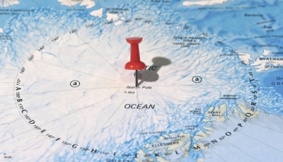
In geographical terms, the North Pole is the northernmost point on Earth’s axis of rotation. It is located in the Arctic, on the drifting, two to three metres thick ice that covers the waters of the ocean here. The warmest the North Pole gets is 0°C. Usually, though, the temperature is a bitterly cold sub-zero. In summer, the North Pole is bathed in the constant daylight, but the winter is a long, continuous dark night.

The North Pole is the northernmost point on Earth. It is the precise point of the intersection of the Earth’s axis and the Earth’s surface.

From the North Pole, all directions are south. Its latitude is 90 degrees north, and all lines of longitude meet there (as well as at the South Pole, on the opposite end of the Earth). Polaris, the current North Star, sits almost motionless in the sky above the pole, making it an excellent fixed point to use in celestial navigation in the Northern Hemisphere.

The North Pole sits in the middle of the Arctic Ocean, on water that is almost always covered with ice. The ice is about 2-3 meters (6-10 feet) thick. The depth of the ocean at the North Pole is more than 4,000 meters (13,123 feet).

The Canadian territory of Nunavut lies closest to the North Pole. Greenland, the world’s largest island and an independent country within the Kingdom of Denmark, is also close to the pole.

The North Pole is much warmer than the South Pole. This is because sits at a lower elevation (sea level) and is located in the middle of an ocean, which is warmer than the ice-covered continent of Antarctica. But it’s not exactly beach weather. In the summer, the warmest time of year, the temperature is right at the freezing point: 0 degrees Celsius (32 degrees Fahrenheit.)

Because the Earth rotates on a tilted axis as it revolves around the sun, sunlight is experienced in extremes at the poles. In fact, the North Pole experiences only one sunrise (at the March equinox) and one sunset (at the September equinox) every year. From the North Pole, the sun is always above the horizon in the summer and below the horizon in the winter. This means the region experiences up to 24 hours of sunlight in the summer and 24 hours of darkness in the winter.

Credit: National Geographic

Picture credit: Google

What are the historical walls around the world?

Walls are often erected as military fortifications. Be it the long, winding ‘Great Wall of China’ or the Peace Walls which are being pulled down, walls are cloaked in mystery and have many tales to narrate. Here is a peek at some of the unique walls in the world.

BERLIN WALL – GERMANY

In 1949, Germany split into two- the East Germany which allied itself to the Soviet Union and West Germany. A large number of people started moving from Soviet-controlled East Germany to the West. In response to this, the country’s government decided to construct a wall. It was built as a barrier surrounding West Berlin thereby preventing any access to West Germany. At first, the wall was built using barbed wire and later followed by concrete. When the Soviet Union began to collapse, the wall was opened and was demolished later.

WALLS OF TROY – TURKEY

Troy is the lost city that has captivated people for years. And so has the Trojan war. This legendary war that was fought between the people of Troy and the Greeks forms the premise of Homer’s Illiad. Even as the occurrence of the Trojan war remains a debate, the city of Troy in Turkey is of archeological interest. The ruins of the famous walls at this ancient site are still standing, whispering legends from the past.

GREAT WALL OF CHINA – CHINA

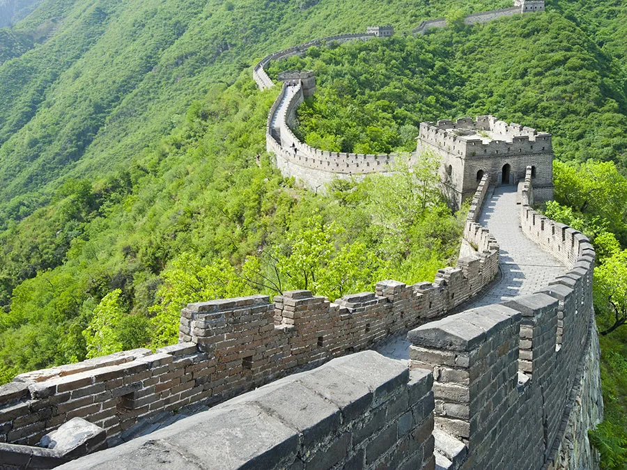
Running more than 20,000 km, the Great Wall of China is the most famous border wall in the world. Its construction started in the 7th century BCE and went on for two millennia. The wall was built across northern China and southern Mongolia. Many workers died during its construction. Although the gigantic wall was built, it could’t withstand the invasions. For instance, Genghis khan and his Mongolian army could easily break in.

BELFAST PEACE WALLS – NORTHERN IRELAND

In Belfast, a unique ‘ritual’ has been going on for the past few years. Here, the walls are being pulled down. Back in 1969, Peace Walls (Peace Lines) were constructed in Belfast to separate Catholic neighbourhoods from Protestants. Northern Ireland was going through a conflict period Troubles, with unionists wanting to be a part of the United Kingdom and nationalists (Catholics) wanting to stay with Ireland. Around 100 walls were eventually erected. In 2013, the Northern Ireland government decided to dismantle the walls to improve community relations and have set 2023 as the target for this. Many walls have been dismantled till now.

GREAT WALL OF GORGAN –IRAN

Built in the 5th- 6th century, the great wall of Gorgan was constructed as a barrier in northern iran. The wall was erected to ward off attacks from the Turks and it comprises around 40 forts.

HADRIAN’S WALL – U.K.

Built in the years of 122-30 CE, by the order of the Roman Emperor Hadrian, the hadrian’s wall ran a length of 72 miles. The Roman frontier was built to protect northwestern Britain from barbarians. The walls give an idea of Roman Empire’s military architecture and also had towers and barracks.

Picture Credit : Google 

Where is Ukraine located?

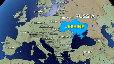
Ukraine is located in Eastern Europe, sharing its borders with Russia, Belarus, Moldova, Romania, Hungary, Slovakia and Poland.

Covering an area of 600,000 square kms, Ukraine is the second largest country in Europe, next only to Russia. It is roughly twice as big as Italy. The landscape of Ukraine is mostly plains and plateaus, with only the Carpathian Mountains in the west rising to impressive heights.

Ukraine has a population 41.3 million people, and the language spoken is mainly Ukrainian; Russian is also spoken by many people. Its capital is Kyiv.

The country is one of the largest grain exporters in the world, blessed with large areas of fertile land. But it is still counted as one of the poorer countries of Europe, haunted by low life expectancy and widespread corruption.

Picture Credit : Google