Category Science

HOW MANY CONSTELLATIONS ARE RECOGNIZED BY INTERNATIONAL ASTRONOMICAL UNION?

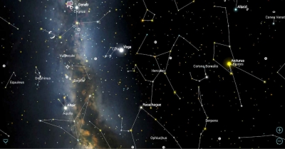
There are 88 modern constellations recognized by the International Astronomical Union (IAU). The list of the modern constellations was adopted by the IAU in 1922. The constellation boundaries as we know them today were set in the late 1920s. 36 modern constellations lie principally in the northern celestial hemisphere, while 52 are found in the southern sky.

The list of the modern constellations and the abbreviations used for them were produced by American astronomer Henry Norris Russell and approved by the IAU in May 1922. Russell’s list corresponded to the constellations listed in the Revised Harvard Photometry star catalogue, published by Harvard College Observatory in 1908. The constellation boundaries were drawn by Belgian astronomer Eugène Delporte and officially adopted in 1928.

The 88 modern constellations have different origins. Most of them are roughly based on the 48 ancient constellations catalogued by the Greek astronomer Claudius Ptolemy of Alexandria in his Almagest, an ancient astronomical treatise written in the 2nd century CE. These constellations are mostly associated with figures from Greek mythology. They include Andromeda, Cassiopeia, Perseus, Pegasus, Hercules, Orion, Ursa Major, Ursa Minor, Canis Major, Canis Minor, Eridanus, and the 12 zodiac constellations.

However, Ptolemy did not create these constellations. They were already well-known to observers long before his time. Even though they are called Greek constellations, they were not necessarily created by the Greeks. Depictions of some of the ancient constellations or the asterisms they are known for go back to prehistoric times and their creators are unknown.

Fifty of the modern 88 constellations are based on the Greek ones. Only one of Ptolemy’s constellations – Argo Navis – is no longer in use. Once the largest constellation in the sky, Argo Navis represented the ship of Jason and the Argonauts. It was divided into three smaller constellations – Carina, Puppis and Vela – by the French astronomer Nicolas-Louis de Lacaille in the 18th century. The three smaller constellations remain in use.

Credit : Constellation-guide

Picture Credit : Google 

WHY SOME SPECIES HAVE YELLOW BLOOD?

When an animal has a high concentration off vanabin in the blood it turns yellow. The yellow color is caused by the metal called vanadium which is found in Vanabin proteins. Scientists do not know why animals have these high concentrations of vanabin as it doesn’t help the circulation of oxygen. So that is still to be explored.

Beetles have yellow-ish blood like several other bugs. You might have noticed this whenever big bug splashes again in the front of your car.

Many people don’t realize that insects typically don’t even have blood vessels. Instead, they have a large hole inside the skeleton where all the blood resides.

Sea Cucumbers have yellow blood. Sea Cucumbers are weird animals. They live down at the bottom of the ocean and are very simple animals. They might look like fruit and the name doesn’t make it easier to categorize this as an animal. But it is an animal and is it quite remarkable. They have thousands of tiny feet as you can see at the picture above. It will move slowly at the bottom of the ocean.Again, the reason for the yellow color is found in the proteins of the blood. It has a high concentration of vanabin which has yellow pigment. One of the strangest facts about Sea Cucumbers is that they can change from male to female during their lifetime. It’s not possible to distinguish the males from the females from the exterior anyway.

Credit : Animal how

Picture Credit : Google 

What is the difference between weathering and Erosion?

Weathering is the result of rocks wearing down because of the actions of the forces of   nature. It is a natural process. During weathering, the rocks in their changed form remain in the same place – there is no movement of material. Erosion, on the other hand, happens when the broken-down rocks are carried away by water, ice, wind or gravity, and the remains are deposited far away from the place where the change initially happened.

Weathering and erosion are forms by which rocks are separated and moved from their unique location. They vary depending on whether a rock’s location is changed: weathering debases a rock without moving it, while erosion diverts rocks and soil from their unique locations. Weathering frequently prompts erosion by making rocks separate into little pieces, which erosive forces would then be able to move away.

Primarily, the difference between erosion and weathering is that weathering happens to set up though erosion includes movement to another location. Both are brought about by quite similar factors such as wind, water, ice, temperature, and even natural activity. They can likewise happen together.

                            Erosion                               Weathering 
Erosion refers to the displacement of the solids through wind, water, and ice. Weathering refers to the decomposition of the rocks, soil, and minerals through direct contact with the atmosphere.
The eroded materials are displaced in the case of erosion. The weathered materials are not displaced in the case of weathering.
The several types of erosion include water, wind, thermal, ice, and gravity erosion. The several types of weathering include physical, chemical, and biological weathering.
Wind, ice, water, and human activities are some of the major causes of erosion. Weathering is caused because of atmospheric factors like air pressure.

Credit: Vedantu

Picture Credit : Google 

HOW QUICKLY DOES LAND GET WORN AWAY?

Erosion is the geological process in which earthen materials are worn away and transported by natural forces such as wind or water. A similar process, weathering, breaks down or dissolves rock, but does not involve movement.

Erosion is the opposite of deposition, the geological process in which earthen materials are deposited, or built up, on a landform.

Most erosion is performed by liquid water, wind, or ice (usually in the form of a glacier). If the wind is dusty, or water or glacial ice is muddy, erosion is taking place. The brown color indicates that bits of rock and soil are suspended in the fluid (air or water) and being transported from one place to another. This transported material is called sediment.

Credit: National Geographic Society

Picture Credit : Google 

WHAT IS GROUNDWATER?

Rainwater seeps below the surface of the Earth and soaks the soil. When there is more water than the soil can absorb, it can seep even further down until it is surrounded by rocks, creating a kind of storage area, known as an aquifer. The water here is groundwater, and the upper level of water is called the water table.

Water that has travelled down from the soil surface and collected in the spaces between sediments and the cracks within rock is called groundwater. Groundwater fills in all the empty spaces underground, in what is called the saturated zone, until it reaches an impenetrable layer of rock. Groundwater is contained and flows through bodies of rock and sediment called aquifers. The amount of time that groundwater remains in aquifers is called its residence time, which can vary widely, from a few days or weeks to 10 thousand years or more.

The top of the saturated zone is called the water table, and sitting above the water table is the unsaturated zone, where the spaces in between rocks and sediments are filled with both water and air. Water found in this zone is called soil moisture, and is distinct from groundwater.

Existing groundwater can be discharged through springs, lakes, rivers, streams, or manmade wells. It is recharged by precipitation, snowmelt, or water seepage from other sources, including irrigation and leaks from water supply systems.

Credit: National Geographic Society

Picture Credit : Google 

WHAT IS SCREE?

Loose rocks of roughly the same size littered on steep mountain slopes.

Scree is a collection of broken rock fragments at the base of a cliff or other steep rocky mass that has accumulated through periodic rockfall. Landforms associated with these materials are often called talus deposits. Talus deposits typically have a concave upwards form, where the maximum inclination corresponds to the angle of repose of the mean debris particle size. The exact definition of scree in the primary literature is somewhat relaxed, and it often overlaps with both talus and colluvium.

The formation of scree and talus deposits is the result of physical and chemical weathering acting on a rock face, and erosive processes transporting the material downslope.

There are five main stages of scree slope evolution: (1) accumulation, (2) consolidation, (3) weathering, (4) encroaching vegetation, and finally, (5) slope degradation.

Credit: Wikipedia

Picture Credit : Google