Category Geography

WHAT MAKES THE SEASONS?

Earth is always tilted the same direction as it orbits the Sun. So when Earth is on one side of the Sun, the northern hemisphere is tilted closer towards the Sun, making it warmer. At the same time, the southern hemisphere is tilted away from the Sun, and is, therefore, colder. When Earth reaches the other side of the Sun, it is the opposite, so it’s winter in the northern hemisphere and summer in the southern.

Seasons happen at different times in different parts of the world. The tilt of the Earth doesn’t change as it rotates around the Sun. But the part of the planet that gets the most direct sunlight does change.

The Northern Hemisphere is tilted away from the Sun from September to March. That means the northern half of the planet doesn’t get as much light and heat from the Sun. This causes autumn and winter. During the same months, the Southern Hemisphere is tilted towards the Sun. That means the southern half of the planet gets spring and summer.

From March to September, the Northern Hemisphere is tilted towards the Sun. So that’s when the northern half of the Earth experiences spring and summer. During the same months, the Southern Hemisphere experiences autumn and winter.
Other planets also have seasons. But the length and intensity of each season varies from planet to planet.

  • On Earth, seasons last between 90 and 93 days.
  • On Venus, seasons last between 55 and 58 days.
  • On Mars, seasons change about once every six months. Summer lasts 199 days and winter lasts 146 days.
  • On Saturn, seasons last about seven years.
  • And if you lived on Neptune, you would have to wait more than 40 years for the seasons to change!

Credit: Let’s talk Science

Picture credit: Google

WHAT IS THE PRIME MERIDIAN?

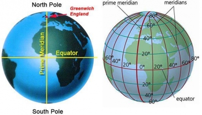
This is an imaginary line of 0° longitude that is perpendicular to the equator, and parallel to the axis. It passes through Greenwich in the UK, and divides Earth into eastern and western hemispheres. As it crosses the poles to the opposite side of the globe, the line becomes 180° longitude and is also known as the International Date Line.

The prime meridian is arbitrary, meaning it could be chosen to be anywhere. Any line of longitude (a meridian) can serve as the 0 longitude line. However, there is an international agreement that the meridian that runs through Greenwich, England, is considered the official prime meridian.

Governments did not always agree that the Greenwich meridian was the prime meridian, making navigation over long distances very difficult. Different countries published maps and charts with longitude based on the meridian passing through their capital city. France would publish maps with 0 longitude running through Paris. Cartographers in China would publish maps with 0 longitude running through Beijing. Even different parts of the same country published materials based on local meridians.

Finally, at an international convention called by U.S. President Chester Arthur in 1884, representatives from 25 countries agreed to pick a single, standard meridian. They chose the meridian passing through the Royal Observatory in Greenwich, England. The Greenwich Meridian became the international standard for the prime meridian.

Credit: National geographic

Picture credit: Google

WHAT ARE LATITUDE AND LONGITUDE?

Every place on Earth’s surface can be pinpointed by two figures: its latitude and its longitude. Lines of latitude (called ‘parallels’) form rings around Earth, parallel to the equator. A place’s latitude is given in degrees (°) north or south of the equator, which is considered latitude 0°. On the other hand, lines of longitude (called ‘meridians’) run round Earth from north to south, dividing the world up like the segments of an orange.

A place’s longitude is given as degrees west or east of the prime meridian, which is longitude 0°.

Latitude and longitude are angles that uniquely define points on a sphere. Together, the angles comprise a coordinate scheme that can locate or identify geographic positions on the surfaces of planets such as the earth.

Latitude is defined with respect to an equatorial reference plane. This plane passes through the center C of the sphere, and also contains the great circle representing the equator. The latitude of a point P on the surface is defined as the angle that a straight line, passing through both P and C, subtends with respect to the equatorial plane. If P is above the reference plane, the latitude is positive (or northerly); if P is below the reference plane, the latitude is negative (or southerly). Latitude angles can range up to +90 degrees (or 90 degrees north), and down to -90 degrees (or 90 degrees south). Latitudes of +90 and -90 degrees correspond to the north and south geographic poles on the earth, respectively.
Longitude is defined in terms of meridians, which are half-circles running from pole to pole. A reference meridian, called the prime meridian , is selected, and this forms the reference by which longitudes are defined. On the earth, the prime meridian passes through Greenwich, England; for this reason it is also called the Greenwich meridian. The longitude of a point P on the surface is defined as the angle that the plane containing the meridian passing through P subtends with respect to the plane containing the prime meridian. If P is to the east of the prime meridian, the longitude is positive; if P is to the west of the prime meridian, the longitude is negative. Longitude angles can range up to +180 degrees (180 degrees east), and down to -180 degrees (180 degrees west). The +180 and -180 degree longitude meridians coincide directly opposite the prime meridian.

Credit: WhatIs.com

Picture credit: Google

WHAT ARE TIME ZONES?

As Earth spins, different parts of its surface turn towards the Sun at different times – the Sun is always rising in one place and setting in another. So, the time of day varies around the world. When it’s dawn where you live, it’s sunset on the other side of the world. To make it easier to set clocks, the world is split into 24 time zones, one for each hour of the day. As you go east around the world, you put clocks forward by one hour for each zone – until you reach an imaginary line called the International Date Line. If you go further on across the Date Line, you carry on adding hours, but put the calendar back by a day.

A time zone is a region on Earth that uses a uniform time. They are often based on the boundaries of countries or lines of longitude. Greenwich Mean Time (GMT) is the mean solar time at the Royal Observatory located in Greenwich, London, considered to be located at a longitude of zero degrees. Although GMT and Coordinated Universal Time (UTC) essentially reflect the same time, GMT is a time zone, while UTC is a time standard that is used as a basis for civil time and time zones worldwide. Although GMT used to be a time standard, it is now mainly used as the time zone for certain countries in Africa and Western Europe. UTC, which is based on highly precise atomic clocks and the Earth’s rotation, is the new standard of today.

UTC is not dependent on daylight saving time (DST), though some countries switch between time zones during their DST period, such as the United Kingdom using British Summer Time in the summer months.

Most time zones that are on land are offset from UTC. UTC breaks time into days, hours, minutes, and seconds, where days are usually defined in terms of the Gregorian calendar. Generally, time zones are defined as + or – an integer number of hours in relation to UTC; for example, UTC-05:00, UTC+08:00, and so on. UTC offset can range from UTC-12:00 to UTC+14:00. Most commonly, UTC is offset by an hour, but in some cases, the offset can be a half-hour or quarter-hour, such as in the case of UTC+06:30 and UTC+12:45

Credit: calculator.net

Picture credit: Google

Gotham, the Big Apple, the City that Never Sleeps, are among the many nicknames of which American city?

New York City is known by many nicknames—such as “the City that Never Sleeps” or “Gotham”—but the most popular one is probably “the Big Apple.” How did this nickname come about? Although uses of the phrase are documented in the early 1900s, the term first became popular in the 1920s when John J. Fitz Gerald, a sports writer, started a column about horse racing called “Around the Big Apple.” However, it wasn’t until a tourism campaign in the 1970s that the nickname came to be synonymous with New York City.

The most populous city in the U.S. also goes by the name Gotham, which was first used by Washington Irving in an 1807 issue of his literary magazine about the legends of an English village named Gotham.
New York City is frequently shortened to simply “New York”, “NY”, or “NYC”. New York City is also known as “The City” in some parts of the Eastern United States, in particular New York State and surrounding U.S. states. Other monikers have taken the form of “Hong Kong on the Hudson” or “Baghdad on the Subway”, references in different cases to the city’s prominence or its immigrant groups.


Picture Credit : Google

What are the interesting facts about the Pyramids of Giza?

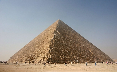
The Great Pyramid of Giza, located on the bank of River Nile in Egypt is one of the Seven Wonders of the Ancient World. Relics of Egypt’s Old Kingdom era, they were constructed nearly 4,500 years ago. Egyptian pharaohs (kings) erected temples and giant tombs for themselves to sustain them in their afterlife. These tombs that we know as pyramids were filled with all the things the pharaohs would need in their afterlife, including gold, boats to carry them. and small tombs for the officials and relatives they would like to accompany them. Today, the Great Pyramid is the oldest and the only remaining ancient wonder of the world.

1. The three pyramids

The Giza pyramid complex has three pyramids. The first pyramid, known as the Great Pyramid of Khufu, was built by Pharaoh Khufu. It is the tallest among the three and was built around 2550 BC. It stands at 481 feet above the plateau.

The second pyramid was built by Khufu’s son, Pharaoh Khafre in 2520 BC. Khafre also built the Sphinx, a mysterious limestone monument of a lion with a pharaoh’s face.

The third pyramid, which is the smallest of the three, was built by Pharaoh Menkaure, son of Khafre, in 2490 BC.

2. The weight of the Great Pyramid

The Great Pyramid of Khufu took nearly 20 years to build. The massive structure required 2.5 million limestone and granite blocks to build. While some of the limestone blocks were quarried from near the site. the larger granite stones were fetched from Aswan, nearly 800 km away. Each stone block on average weighed 2.5 tonnes. The pyramid was built by skilled Egyptian workers who lived in a temporary city close by. When it was completed, the Great Pyramid was the tallest structure in the world. It retained the title for nearly 3,800 years, when it was finally overtaken by the Lincoln Cathedral in the 1300s. Experts estimate that the Great Pyramid would cost over 1 billion dollars if it were to be built today.

3. Aligned to the stars

The three pyramids of the Giza necropolis are built in such a way that they are perfectly aligned with the Orion constellation.

4. The monument of Glorious Light

In its initial years, the Great Pyramid was covered in highly polished limestone blocks known as casing stones. These stones reflected the Sun’s light so well that the people of ancient Egypt used to call the Great Pyramid Ikhet, meaning GloriouS Light. The casing stones are now gone. It is suspected that massive earthquakes loosened the stones and they were taken away to build mosques in Cairo.

5. Depicting life in ancient Egypt

The interiors of the Pyramids of Giza are decorator with scenes from every aspect of life in ancient Egypt. The art includes depictions of carpentry, costumes, ancient farmers working in their fields, fishing, religious rituals and burial practices among others. The pyramids also contain inscriptions and texts that allow experts to research ancient Egyptian language and grammar.


Picture Credit : Google