Category Geography

WHERE IS THE TROPOSPHERE THE THINNEST?

The troposphere can be found between the ground and an altitude of 7 to 20 kilometers (4 to 12 miles). The lesser thickness is found at the Polar Regions, since colder temperatures lead to a decrease in gas volume. The vast majority of the world’s weather is formed in the troposphere and this layer also contains 80 percent of the atmosphere’s mass. The temperature within the troposphere drops with altitude, since it is essentially being warmed by the ground. The pressure also drops within the troposphere as altitude increases, and this explains why mountaineers require oxygen masks.

Credit: Sciencing

Picture credit: Google

WHAT IS THE IONOSPHERE?

It is another layer, overlapping the mesosphere, thermosphere and exosphere, where radio waves are reflected.

A dense layer of molecules and electrically charged particles, called the ionosphere, hangs in the Earth’s upper atmosphere starting at about 35 miles (60 kilometers) above the planet’s surface and stretching out beyond 620 miles (1,000 km). Solar radiation coming from above buffets particles suspended in the atmospheric layer. Radio signals from below bounce off the ionosphere back to instruments on the ground. Where the ionosphere overlaps with magnetic fields, the sky erupts in brilliant light displays that are incredible to behold.

Several distinct layers make up Earth’s atmosphere, including the mesosphere, which starts 31 miles (50 km) up, and the thermosphere, which starts at 53 miles (85 km) up. The ionosphere consists of three sections within the mesosphere and thermosphere, labeled the D, E and F layers, according to the UCAR Center for Science Education.

Extreme ultraviolet radiation and X-rays from the sun bombard these upper regions of the atmosphere, striking the atoms and molecules held within those layers. The powerful radiation dislodges negatively charged electrons from the particles, altering those particles’ electrical charge. The resulting cloud of free electrons and charged particles, called ions, led to the name “ionosphere.” The ionized gas, or plasma, mixes with the denser, neutral atmosphere.

Credit: Live Science

Picture credit: Google

IN WHICH LAYER OF THE ATMOSPHERE DO SATELLITES ORBIT EARTH?

You can consider most satellites to be in space, but in terms of the Earth’s atmosphere, they occupy regions called the thermosphere and the exosphere. The layer through which a satellite orbits depends on the satellite’s function and the kind of orbit it has. Since the launch of Sputnik in the 1950s, spacefaring countries have put thousands of satellites into orbit around the Earth and even other planets. They serve many different purposes, from complex space stations like the International Space Station to the Global Positioning System that helps you find your way home.

Thermosphere: High Temperatures

The thermosphere is a region of very high temperature that extends from the top of the mesosphere at around 85 kilometers (53 miles) up to 640 kilometers (400 miles) above the Earth’s surface. It is called the thermosphere because temperatures can reach up to 1,500 degrees Celsius (2,732 degrees Fahrenheit). However, despite the high temperatures, the pressure is very low, so satellites don’t suffer heat damage.

Exosphere: Farthest Reaches

Above the thermosphere sits a final layer called the exosphere, which extends up to 10,000 kilometers (6,200 miles) above the Earth, depending on how it is defined. Some definitions of the exosphere include all space up until the point where atoms get knocked away by solar wind. No distinct upper boundary exists since the exosphere has no pressure and molecules float freely here. Eventually, the exosphere gives way to space outside of the Earth’s influence.

Credit: Sciencing

Picture credit: Google

WHAT IS AIR PRESSURE?

The air around you has weight, and it presses against everything it touches. That pressure is called atmospheric pressure, or air pressure. It is the force exerted on a surface by the air above it as gravity pulls it to Earth.

Atmospheric pressure is commonly measured with a barometer. In a barometer, a column of mercury in a glass tube rises or falls as the weight of the atmosphere changes. Meteorologists describe the atmospheric pressure by how high the mercury rises.

An atmosphere (atm) is a unit of measurement equal to the average air pressure at sea level at a temperature of 15 degrees Celsius (59 degrees Fahrenheit). One atmosphere is 1,013 millibars, or 760 millimeters (29.92 inches) of mercury.

Atmospheric pressure drops as altitude increases. The atmospheric pressure on Denali, Alaska, is about half that of Honolulu, Hawai’i. Honolulu is a city at sea level. Denali, also known as Mount McKinley, is the highest peak in North America.

As the pressure decreases, the amount of oxygen available to breathe also decreases. At very high altitudes, atmospheric pressure and available oxygen get so low that people can become sick and even die.

Mountain climbers use bottled oxygen when they ascend very high peaks. They also take time to get used to the altitude because quickly moving from higher pressure to lower pressure can cause decompression sickness. Decompression sickness, also called “the bends”, is also a problem for scuba divers who come to the surface too quickly.

Aircraft create artificial pressure in the cabin so passengers remain comfortable while flying.

Atmospheric pressure is an indicator of weather. When a low-pressure system moves into an area, it usually leads to cloudiness, wind, and precipitation. High-pressure systems usually lead to fair, calm weather.

Credit: Society

Picture credit: Google

WHAT IS THE STUDY OF FOSSILS CALLED?

Paleontology is the study of the history of life on Earth as based on fossils. Fossils are the remains of plants, animals, fungi, bacteria, and single-celled living things that have been replaced by rock material or impressions of organisms preserved in rock.

Paleontology, also spelled Palaeontology, scientific study of life of the geologic past that involves the analysis of plant and animal fossils, including those of microscopic size, preserved in rocks.

Paleontologists look at fossils, which are the ancient remains of plants, animals, and other living things. Fossils are mainly formed in two ways.

Credit: lisbdnet.com

Picture credit: Google

What kind of country is Kiribati?

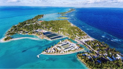
Kiribati, an island chain in the Pacific Ocean, is the only country in the world that is situated within all four hemispheres of the globe.

Despite having a population of 120,000 and a land mass of 811 squared kilometres, there is almost 4000 kilometres between the easternmost and westernmost parts of Kiribati – which is almost as wide as Australia.

At its highest point, Kiribati stands at a mere height of just eight metres above sea level. Once combined, the 33 stunning, paradisiac islands and atolls make Kiribati the only country in the world to cross all four hemispheres.

With such remoteness comes great challenges. However, since becoming a member association in 2010, the federation have made encouraging progress in their effort to bring badminton to a small nation.

Leading the charge for badminton is Kiribati’s Shuttle Time Co-ordinator Tongoboo Beero, who first came across Shuttle Time in 2012 as a participant. Since then, Tongoboo has powered through the ranks.

In 2019, he was one of 10 trained Shuttle Time teachers who inspired over 600 participants into getting fit and active within their communities with badminton. Earlier this year, he was part of a leadership team who delivered teacher training to expand Kiribati’s Shuttle Time teacher pool. His combined efforts earned his a space in the BWF’s Humans of Shuttle Time campaign.

Moreover, other teachers from Kiribati have noticed a significant rise in popularity. Taonibeia Mwakuti has delivered to more than 50 kids in her local community, which has made a big difference to their lives where there are only a limited number of other activities to keep them engaged.

“We both enjoy the game and can say that we have improved a lot especially with our grips and serving technique” say Mwakuti’s students, Biritia Peter and Eimwa Obwaia.

The complex logistics involved in sending and receiving badminton equipment is one issue for the remote nation. However, finding a suitable badminton court to play on is another.

To combat the lacking badminton facilities, many of the Pacific Islands play outdoors. However, Shuttle Time teachers and students came together recently to paint the lines of a badminton court under a shelter to give a better understanding of the game.

Credit : Badminton Oceania

Picture Credit : Google