Nestled in-between the eastern ridges of the Himalayas in the central-south, Bhutan is a beautiful country and is also ranked as one of the happiest countries in the world, attracting tourists from far and wide to experience its tranquil and serene beauty. This beautiful Buddhist kingdom is renowned for its breathtaking landscapes and plains, magnificent mountains and steep valleys.
Bhutan is a small kingdom neighbouring India with a 786,500 population. It is also known as Druk yul or Druk Tsendhen, meaning “land of the thunder dragon”, because of the frequent thunderbolts experienced here. However, it is a place of mountains and lakes, pilgrimages, artistic skills, adventure and tourism.
Bhutan does not believe in GDP as an indicator of economic growth and development, using instead a measurement known as Gross National Happiness. It has made this blessed kingdom a country of happy people on the global map. Bhutanese people have four pillars for the measure of GNH -sustainable development, preservation and promotion of cultural values, good governance and a healthy environment that makes it one of the happiest countries in the world.
People
There are three major ethnic groups in Bhutan: the Bhutia (also called Ngalop), the Nepalese and the Sharchop. The Bhutia is the largest ethnic group and they constitute about half of the population. The Bhutia are dominant in northern, central and western Bhutan. They speak a variety of Tibeto-Burman languages, and the most common of these, Dzongkha, is Bhutan’s official language; the written language is identical with Tibetan. The Bhutias dominate Bhutan’s political life. The Nepalese (including members of the Gurung ethnic group) predominate in the region and constitute roughly one-third of the country’s total population. These are the most recent arrivals in Bhutan. Most speak Nepali.
About three-fourths of Bhutan’s population follows Buddhism, primarily of the Tibetan variety. Besides Buddhism, Hinduism commands a significant following in Bhutan, particularly within the Nepalese community. Hindus constitute nearly one-fourth of the population. Proselytization is illegal in Bhutan.
Flora and Fauna
Bhutan’s flora is notable for its great variety and its continuous transition from tropical through temperate to exclusively alpine forms. The moist zone of tropical deciduous vegetation occupies the south; in the Duars Plain and adjoining hills, tall dense grasses (used in the manufacture of paper and pulp) are an important plant resource in the lower elevations.
Sambar deer, gaurs (type of wild ox), rhinoceros, elephants, tigers and other animals are found in Bhutan, particularly along the Manas and Sankosh rivers in the central and eastern regions and in the country’s forest-covered hills.
Art and Culture
Various art forms in Bhutan are inspired by the Buddhist religion. Poetry, dance, music, paintings and theatre in the country is deep rooted in the religion. Paintings include thangkas, wall paintings and sculptures. Masked dances are the main speciality, which are the re-enactment of Guru Rinpoche’s life. Architecture is another feature which makes Bhutanese culture stand apart. In accordance with the country’s geography and climate, traditional architecture, which includes sloped roofs, earthen walls and intricate wooden work, still thrives.
The festivals in Bhutan are an exciting time in the life of the Bhutanese, and an integral part of the unique culture of Bhutan. The most important Bhutanese festival is Tshechu. Every city has its own Tshechu, which lasts for 3-5 days. It falls on a particular day of a lunar month. It is generally held in a dzong, where people from the entire district and surrounding places gather together for the celebration. Monks and lay men wear silk robes and animal masks and re-enact events from Guru Rinpoche’s life.
Bhutanese culture mandates that the traditional dress must be worn on special occasions and in government offices. Bhutanese men wear gho and women wear kira. Gho is a heavy knee-length robe tied with a belt. Kira is an ankle-length dress over which a short jacket may be worn.
Traditionally food, cooked in earthenware, is eaten with hands while sitting cross-legged on the floor. Ema Datshi is the national dish of Bhutan. It is eaten throughout the country and in almost every meal. It usually consists of spicy chillies and cheese. Momos are yet another Bhutanese delicacy.
The music and dance forms of Bhutan, which are primarily inspired by religion, are part of every festival and celebration in the country. In annual events such as Tshechus, the king’s birthday, etc., the whole country celebrates their legacy by dancing and singing.
Places of Interest
The Royal Manas National Park is the oldest in Bhutan and is spread across an area of 1,057 sq. km with numerous endangered wildlife species including the one horned rhino, Royal Bengal tiger, clouded leopard, Gangetic dolphin, Himalayan black bear, golden langur and many more.
Soi Yaktsa Trek: Trekking, undoubtedly, is one of the best adventure activities in Bhutan. The Soi Yaksa Trek has climbs that lead up to elevations as high as 4,700 m.
Pilgrim’s Valley: It is one of the best Bhutan tourist spots covering the monasteries and dzongs from Paro to Bumthang.
Buddha Dordenma, Thimphu: It is the ultimate destination for photography with a giant golden Shakyamuni Buddha statue constructed to commemorate the anniversary of the fourth king of Bhutan, Jigme Singye Wangchuk.
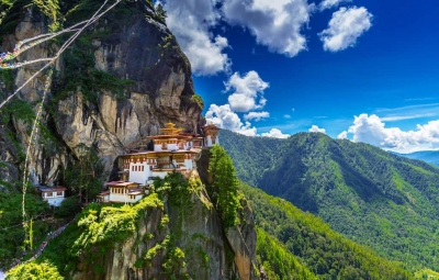
Taktsang Palphug Monastery, Paro: Popularly known as Tiger’s Nest, it is one of the fascinating places for adventurers and pilgrims. The temple complex dates back to 1692.
Punakha Suspension Bridge, Punakha: The 160-metre long bridge spans the Po Chhu River, and connects Punakha Town with Punakha Dzong. It offers breathtaking views of the river flowing below and lush green hills all around it.
Interesting Facts about Bhutan
1. The ONLY carbon negative country in the world
Bhutan absorbs more carbon dioxide than it produces. Thanks to its lush forests which act as a carbon sink and absorb most of the carbon dioxide.
2. Isolated from the world until the 1970s
Bhutan was isolated entirely from the world until 1974 when the media was allowed to cover the new king’s coronation, about 64 years since it was founded. Television sets came to Bhutan no sooner than 1990.
3. No smoking in public places
Smoking and usage of tobacco products are prohibited in public places like cinema halls, restaurants, streets, etc. Designated areas have been created for smokers, and anyone caught breaking the law face imprisonment for 3-5 years.
4. Birthday on New Year?
All citizens officially become a year older on New Year’s Day. If people forget their birthday due to illiteracy or any other reason, it is easier to remember it by celebrating it on New Year’s Day.
5. Bhutan has never been conquered
Bhutan has never been ruled by an external entity, thanks to its inaccessible territory and smart decisions and tactics by various kings and gurus who negotiated smart deals with the British when they were expanding their base in India and Nepal.
6. Education and healthcare is free for all citizens
The Government has taken necessary steps to ensure free health and educational facilities for all. The infant mortality rate is still a severe issue, but it has improved drastically. Most people still get their education from monasteries, and steps are being taken to increase the literacy rate.
7. The national sport is archery
The bow and arrow has played a significant role in many Bhutanese myths and legends. Bhutan maintains an Olympics archery team too.
8. Matriarchal family tradition
Women head the families and run all businesses from shops to farms. They even inherit property, and a man moves into his wife’s house after marriage. Looks like feminism isn’t much of an issue in Bhutan!
9. Bhutanese love their king!
The King of Bhutan is known for his humble personality and humanitarian efforts. Rightly called the “People’s King”, His Majesty Jigme Khesar Namgyel Wangchuck has met almost every citizen of his country and loves to talk to the people personally about their griefs and requirements.
10. It is mandatory to wear the national dress
It is mandatory to wear the national dress of Bhutan (gho for men and kira for women) to schools and government buildings on any formal occasion.
Bhutan has been a favoured destination for people around the world for its exquisite beauty, clean air, unique features and friendly administration. Tourists visiting Bhutan have always been awed by its unique culture and bountiful nature. Bhutan has led the banner for wellness travel for long, making their tourists’ and their citizens’ wellness a priority. Bhutan could be top priority on your wish list if you are planning to travel soon.
Picture Credit : Google


