Mount Roraima, Spanish Cerro Roraima or Monte Roraima, Portuguese Monte Roraímã, giant flat-topped mountain, or mesa, in the Pakaraima Mountains of the Guiana Highlands, at the point where the boundaries of Brazil, Venezuela, and Guyana meet.
Mount Roraima is situated on the border of Venezuela, Guyana and Brazil, with almost 75% of the mountain falling into Venezuelan territory.
Whilst the tepui (table-top mountain) is the highest landform in Guyana, both Brazil and Venezuela have higher landmarks.
The summit experiences heavy rainfall all year round, which as a result of its flat surface, leads to random waterfalls popping up at various locations across the plateau.
Angel Falls, the tallest waterfall in the world, is located on a similar table-top mountain approximately 130 miles away, and falls within the same national park.
The formation was first described by the English explorer Sir Walter Raleigh in 1596 after his visit to Guyana in search of the legendary golden city of El Dorado, but frustratingly he was unable to climb it as no viable route to the summit was known at the time.
Mt. Roraima was the first major tepui in the world to be climbed in 1884, when Everard Thurn trekked up a forested trail. This trail is the only ‘easy’ way up, following a natural staircase like route on the Venezuelan side. Other routes do exist, though are extremely difficult and require technical rock climbing experience. Everard Thurn later went on to become the Governor of Fiji.
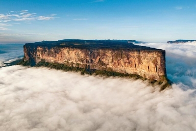
The summit measures 31 sq. km (12 sq. mi), and is usually covered in fog. It features black rocks, gorges, wildflower gardens and a number of pools.
The mountain has always had special significance to the indigenous Pemon Indians, and is central to many legends and myths passed down through generations. They view Roraima as the stump of a ginormous tree that once held all the fruits and vegetables in the world.
Translated, roroi means “blue green” and ma means “great” in the native language of the Pemon.
Mount Roraima and the other tabletop mountains in Canaima National Park are considered to be the oldest geological formations on Earth, dating back around 2 billion years to the Precambrian Era.
Credit : Britannica
Picture Credit : Google


