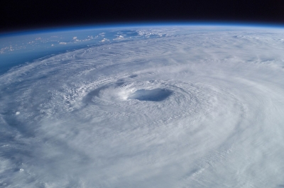
The most dangerous and destructive part of a tropical cyclone is the eyewall. Here winds are strongest, rainfall is heaviest, and deep convective clouds rise from close to Earth’s surface to a height of 15,000 metres (49,000 feet). As noted above, the high winds are driven by rapid changes in atmospheric pressure near the eye, which creates a large pressure gradient force. Winds actually reach their greatest speed at an altitude of about 300 metres (1,000 feet) above the surface. Closer to the surface they are slowed by friction, and higher than 300 metres they are weakened by a slackening of the horizontal pressure gradient force. This slackening is related to the temperature structure of the storm. Air is warmer in the core of a tropical cyclone, and this higher temperature causes atmospheric pressure in the centre to decrease at a slower rate with height than occurs in the surrounding atmosphere. The lessened contrast in atmospheric pressure with altitude causes the horizontal pressure gradient to weaken with height, which in turn results in a decrease in wind speed.
Friction at the surface, in addition to lowering wind speeds, causes the wind to turn inward toward the area of lowest pressure. Air flowing into the low-pressure eye cools by expansion and in turn extracts heat and water vapour from the sea surface. Areas of maximum heating have the strongest updrafts, and the eyewall exhibits the greatest vertical wind speeds in the storm—up to 5 to 10 metres (16.5 to 33 feet) per second, or 18 to 36 km (11 to 22 miles) per hour. While such velocities are much less than those of the horizontal winds, updrafts are vital to the existence of the towering convective clouds embedded in the eyewall. Much of the heavy rainfall associated with tropical cyclones comes from these clouds.
The upward movement of air in the eyewall also causes the eye to be wider aloft than at the surface. As the air spirals upward it conserves its angular momentum, which depends on the distance from the centre of the cyclone and on the wind speed around the centre. Since the wind speed decreases with height, the air must move farther from the centre of the storm as it rises.
When updrafts reach the stable tropopause (the upper boundary of the troposphere, some 16 km [10 miles] above the surface), the air flows outward. The Coriolis force deflects this outward flow, creating a broad anticyclonic circulation aloft. Therefore, horizontal circulation in the upper levels of a tropical cyclone is opposite to that near the surface.
Picture Credit : Google