Our Earth is a water world. It is the availability of water that makes our planet unique in the solar system. Approximately 71% of the earth’s surface is covered by water. The oceans and the seas account for 97%. The rest exists as lakes and rivers, as glaciers and ice caps, and as aquifers. This is so enormous an area that any amount of knowledge of the science and geography of water sources wouldn’t be enough. There are different forms of studies such as hydrology, oceanography and limnology that try to understand water and water bodies. And today, we are going to focus on hydrography.
What is hydropgraphy? In the past, ships were one of the major transport systems – they ferried people and goods across the world. But they often ran aground or overturned after striking an underwater rock or mudbank. The need to know the geography of the ocean floors, thus, was strongly felt. Individual mariners began to make charts and describe the bodies of the water to aid navigation. Today, surveyors use technology to map the sea floor. and scientifically and systematically measure and describe the physical features of bodies of water, including the ocean, coastal zones, rivers, and lakes. This is called hydrography.
Hydrography involves measuring the depth of the water and fixing the position of all the navigational hazards that lie on the senfloor, such as: wrecks and rocks. That data is used to update nautical charts and develop hydrographic models Hydrography also involves measuring the tide and the currents
Hydrography comprises two distinct branches. While marine hydrography is the study of the ocean floor, the coasts, tides and currents, hydromorphometric is dedicated to the study of river basins their shapes, dimensions and composition. The second branch helps us apply the knowledge for irrigation, river navigation and power generation.
Today, hydrographic maps are important in informing ocean resource management policies, predicting geohazards, and characterising habitats. Some hydrographers also study the physical and chemical properties of the sea and other water bodies, such as temperature, dissolved oxygen, and salinity.
How is hydrography done?
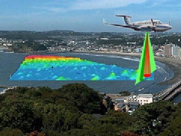
Surveying with multibeam echo sounders is the primary method of obtaining hydrographic data. The beams sweep the seafloor and bounce off details of the depth of the surveyed area. Sonan, aircraft fitted with lasers and satellite observations are also used in hydrography.
Picture Credit : Google


