Category Rivers

Why is the Yellow River often referred to as “China’s Sorrow”?

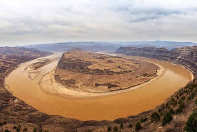
The Yellow River is also called “China’s Sorrow”. Each year, over 1.6 billion tons of soil flows into the Yellow River, which causes the continual rise and shift of the riverbed. Before damming, it was extremely prone to flooding, and had caused millions of deaths, including the deadliest disaster in human history.

With global warming, decrease in rainfall in the Yellow River Basin, and increasing water demands for irrigation, industry, etc., the Yellow River has been used up by its lower reaches since 1972, when it ran dry for the first time in recorded history. The longest dry period lasted 226 days in 1997.

Drought in the Yellow River region has brought serious challenges to agricultural development and the cities near the Yellow River.

What’s worse, the river has been abused. It has become so polluted in some reaches that it is unfit for agricultural and industrial use, because of the huge increase in factory and sewage discharges from China’s fast-expanding cities.

The government is taking measures to deal with Yellow River pollution, such as setting limits on the volume of major pollutants discharged into rivers and lakes, and controlling overuse of water resources.


Picture Credit : Google

The 1908 flooding of which river divides Hyderabad into the historic old city and the new city?

As Kerala grapples with a deluge of unimaginable proportions, the second time in under 100 years, it is interesting to remember the Hyderabad experience. Around 110 years ago on September 26, 1908, it began to rain in the surrounding areas of Hyderabad as a result of a cyclone in the Bay of Bengal. Over the next 48 hours, the downpour continued in the Musi river basin logging 98.57 cm rainfall. Of the 788 tanks and lakes in the river basin, 221 breached due to the cloudburst. 

According to historian Benjamin Cohen, the flood and deaths were used by the Nizam and his advisers to remake the city in a way that made it flood-proof. It also changed the power equations of the city.


Picture Credit : Google

From which river the Dead Sea receives almost all its water?

The northern half of the western shore lies within the Palestinian West Bank and has been under Israeli occupation since the 1967 Arab-Israeli war. The Jordan River, from which the Dead Sea receives nearly all its water, flows from the north into the lake.

The Dead Sea has the lowest elevation and is the lowest body of water on the surface of Earth. The Dead Sea lies in a desert. Rainfall is scanty and irregular. Al-Lis?n averages about 2.5 inches (65 mm) of rain a year, the industrial site of Sedom (near historical Sodom) only about 2 inches (50 mm). 

The waters of the Dead Sea are extremely saline, and, generally, the concentration of salt increases toward the lake’s bottom. That phenomenon can create two different masses of water in the lake for extended periods of time. Such a situation existed for some three centuries, lasting until the late 1970s.


Picture Credit : Google

In which country Yangtze River found?

Yangtze River, Chinese (Pinyin) Chang Jiang or (Wade-Giles Romanization) Ch’ang Chiang, longest river in both China and Asia and third longest river in the world, with a length of 3,915 miles (6,300 kilometres). Its basin, extending for some 2,000 miles (3,200 km) from west to east and for more than 600 miles (1,000 km) from north to south, drains an area of 698,265 square miles (1,808,500 square km). The Yangtze has eight principal tributaries. On its left bank, from source to mouth, these are the Yalung, Min, Jialing, and Han rivers; those on the right bank include the Wu, Yuan, Xiang, and Gan rivers.

The name Yangtze—derived from the name of the ancient fiefdom of Yang—has been applied to the river mainly by those in the West. Chang Jiang (“Long River”) is the name used in China, although it also is called Da Jiang (“Great River”) or, simply, Jiang (“[The] River”). The Yangtze is the most important river of China. It is the country’s principal waterway, and its basin is China’s great granary and contains nearly one-third of the national population.


Picture Credit : Google

Which is the longest river in Europe?

The longest river in Europe is the Volga, in Russia. It is 3,645 kilometres long and is the 15th longest river in the world. It is also Europe’s largest river in terms of discharge, with 8,060 cubic metres per second.

Its source is in the Valdai Hills, 228 metres above sea level, and it flows through ten Russian oblasts (Tver, Yaroslavl, Kostroma, Ivanovo, Nizhny Novgorod, Ulyanovsk, Samara, Saratov, Volgograd and Astrakhan) and three republics (Mari El, Chuvashia and Tatarstan).

It flows into the Caspian Sea, and almost its entire course is navigable. The Volga’s main tributaries are the Kama and the Oka rivers, and it has a total of about 200 tributaries.


Picture Credit : Google

How many rivers flow in Saudi Arabia?

Saudi Arabia does not have any permanent rivers, but does have numerous wadis (valley) which are riverbeds that are either permanently or intermittently dry.

This list is arranged by drainage basin, with respective tributaries indented under each larger stream’s name.

Saudi Arabia has the largest economy in the Middle East, and as of 2018, it was the 18th largest economy globally. Saudi Arabia has no permanent rivers within its border. It is one of the 17 countries in the world without rivers.

Saudi Arabia had deep water holes around the ‘Al-Kharj and lakes at the Layla Aflaj up until the 1980s. They were fed by massive underground aquifers that were formed several millions of years ago. The ‘Al-Kharj was a critical source of drinking water. However, there are Wadis that serve as the source of water. The Wadis refer to a valley or a dry river bed which contain water, especially during the rainy season. Saudi Arabia stores approximately 6 billion cubic feet of water in the more than 200 dams found in the Wadi Bisha, Wadi Jizan, Wadi Fatima, and Najran among others.


Picture Credit : Google