Category Rivers

The Harappan civilization flourished around which river valley?

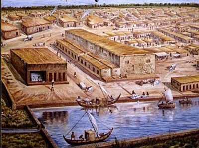
The Harappan civilization was located in the Indus River valley. Its two large cities, Harappa and Mohenjo-daro, were located in present-day Pakistan’s Punjab and Sindh provinces, respectively. Its extent reached as far south as the Gulf of Khambhat and as far east as the Yamuna (Jumna) River.

Before the excavation of these Harappan cities, scholars thought that Indian civilization had begun in the Ganges valley as Aryan immigrants from Persia and central Asia populated the region around 1250 BCE. The discovery of ancient Harappan cities unsettled that conception and moved the timeline back another 1500 years,situating the Indus Valley Civilization in an entirely different environmental context.

The Indus River Valley Civilization is considered a Bronze Age society; inhabitants of the ancient Indus River Valley developed new techniques in metallurgy—the science of working with copper, bronze, lead, and tin. Harappans also performed intricate handicraft using products made of the semi-precious gemstone Carnelian.


Picture Credit : Google

On which river bank is the Taj Mahal situated?

 The Taj Mahal was built on the banks of the river Yamuna, between 1631 and 1643, by the Mughal emperor Shah Jahan as a mausoleum for his beloved wife Arjumand Banu Begum, who was also known by the title Mumtaz Mahal. 

The Taj Mahal was designated as a UNESCO World Heritage Site in 1983 for being “the jewel of Muslim art in India and one of the universally admired masterpieces of the world’s heritage”. It is regarded by many as the best example of Mughal architecture and a symbol of India’s rich history. The Taj Mahal attracts 7–8 million visitors a year and in 2007, it was declared a winner of the New 7 Wonders of the World (2000–2007) initiative.

The Taj Mahal incorporates and expands on design traditions of Persian and earlier Mughal architecture. Specific inspiration came from successful Timurid and Mughal buildings including the Gur-e Amir (the tomb of Timur, progenitor of the Mughal dynasty, in Samarkand), Humayun’s Tomb which inspired the Charbagh gardens and hasht-behesht (architecture) plan of the site, Itmad-Ud-Daulah’s Tomb (sometimes called the Baby Taj), and Shah Jahan’s own Jama Masjid in Delhi. While earlier Mughal buildings were primarily constructed of red sandstone, Shah Jahan promoted the use of white marble inlaid with semi-precious stones. Buildings under his patronage reached new levels of refinement.


Picture Credit : Google

Which is the last Indian State the Himalayan River Ganges enters before flowing into Bangladesh and eventually into the Bay of Bengal?

 West Bengal is the last Indian state that the Ganges enters, and, after it flows into Bangladesh, the Mahananda River joins it from the north. In West Bengal in India, as well as in Bangladesh, the Ganges is locally called the Padma. The westernmost distributaries of the delta are the Bhagirathi and the Hugli (Hooghly) rivers, on the east bank of which stands the huge metropolis of Kolkata (Calcutta). The Hugli itself is joined by two tributaries flowing in from the west, the Damodar and the Rupnarayan. As the Ganges passes from West Bengal into Bangladesh, a number of distributaries branch off to the south into the river’s vast delta. In Bangladesh the Ganges is joined by the mighty Brahmaputra (which is called the Jamuna in Bangladesh) near Goalundo Ghat. The combined stream, there called the Padma, joins with the Meghna River above Chandpur. The waters then flow through the delta region to the Bay of Bengal via innumerable channels, the largest of which is known as the Meghna estuary.

The rivers in the West Bengal area are sluggish; little water passes down them to the sea. In the Bangladeshi delta region, the rivers are broad and active, carrying plentiful water and connected by innumerable creeks. During the rains (June to October) the greater part of the region is flooded to a depth of 3 or more feet (at least 1 metre), leaving the villages and homesteads, which are built on artificially raised land, isolated above the floodwaters. Communication between settlements during that season can be accomplished only by boat.


Picture Credit : Google

Which is the longest river in Australia?

The calculations confirmed that Australia’s longest single river is the River Murray at 2508 kilometres. However, if the longest tributaries of the Darling River, the Culgoa, Balonne and Condamine, are taken into account its total length increases to 2740 kilometres, making it Australia’s longest waterway.

The National Topographic Database is a nationally consistent dataset containing a range of topographic features, such as relief and drainage, which has been captured and maintained at a scale of 1:250 000 for the whole of Australia. Use of the database to digitally calculate the longest rivers has resulted in more precise estimates than those available previously.

The Murray River was first discovered by European explorers Hamilton H. Hume and William H. Hovell in 1824. It wasn’t until five years later, however, that Charles Sturt navigated down the Murrumbidgee to encounter the Murray and named it after Sir George Murray, (Soldier and Tory Party Politician 1772-1846) when his exploration party encountered the Darling connection. Sturt had previously explored the Darling River to the north and was able to determine that they were indeed the same river system.

The Murray River is the world’s 16th-longest river at 2,520 kilometres from its source in the Kosciusko National Park. It is fed by several rivers on it’s journey from the Australian Alps. The main feeding rivers are the Darling and Murrumbidgee Rivers. The Darling River (2,740 kilometres) begins in the far inland of Australia (Queensland) and joins the Murray at Wentworth (NSW) then flows to the Southern Ocean through South Australia.


Picture Credit : Google

On which river bank did the Battle of the Hydaspes happen?

Battle of the Hydaspes, (326 BCE), fourth and last pitched battle fought by Alexander the Great during his campaign of conquest in Asia. The fight on the banks of the Hydaspes River in India was the closest Alexander the Great came to defeat. 

The battle took place on the east bank of the Hydaspes River (now called the Jhelum River, a tributary of the Indus River) in what is now the Punjab Province of Pakistan. Alexander later founded the city of Nicaea on the site; this city has yet to be discovered. Any attempt to find the ancient battle site is complicated by considerable changes to the landscape over time. For the moment, the most plausible location is just south of the city of Jhelum, where the ancient main road crossed the river and where a Buddhist source mentions a city that may be Nicaea. The identification of the battle site near modern Jalalpur/Haranpur is certainly erroneous, as the river (in ancient times) meandered far from these cities.

Alexander had to subdue King Porus in order to keep marching east.[citation needed] To leave such a strong opponent at his flanks would have endangered any further exploits. Alexander could not afford to show any weakness if he wanted to keep the loyalty of the already subdued Indian princes. Porus had to defend his kingdom and chose the perfect spot to check Alexander’s advance. Although he lost the battle, he became the most successful recorded opponent of Alexander.


Picture Credit : Google

In which country does River Kwai flow?

The River Kwai, more correctly ‘Khwae Noi’ or Khwae Sai Yok is a river in western Thailand, near, but not over the border with Myanmar. It begins at the confluence of Ranti, Songkalia and Bikhli Rivers. 

The river is chiefly known from the Pierre Boulle novel and David Lean film The Bridge on the River Kwai, in which Australian, Dutch and British prisoners of war were forced by the Japanese to construct two parallel bridges spanning the river as part of the Burma Railway, also called the Death Railway, for the many lives lost in its construction. One bridge was wooden and temporary. The other was made of concrete and steel and still exists. The bridges actually spanned the Mae Klong, but as the railway subsequently follows the Khwae Noi Valley, the bridges became famous under the wrong name. In the 1960s, the upper part of the Mae Klong was renamed the Khwae Yai (big tributary”).

River Kwai Noi also runs through a national park, Saiyok National Park. The park’s area is approximately 500 square kilometers. Its landscape and scenery are arguably the most beautiful places in Thailand where once the famous Death Railway passed though Sai Yok Noi. The park’s major attractions are its waterfalls, including Sai Yok Yai waterfall which flows into the Khwae Noi river (River Kwai Noi).


Picture Credit : Google