Category Earth Science

What is Estuary or delta?

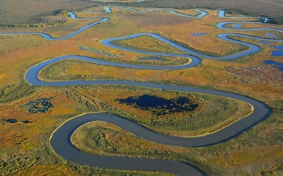
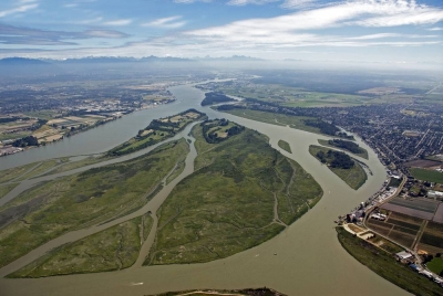
Near the sea, salt water mixes with fresh water, forming an estuary. The land is flatter, so the river slows down. If it slows down enough, mud is deposited, creating a delta with several channels that the river now flows through.

The basic difference between estuary and delta is that the former is a tidal mouth of the river, where it meets the sea, whereas the latter is nothing but the wetland, formed as a result of the accumulation of sediments carried by the river when it joins a standing water body.

While an estuary is a semi-enclosed body of water, where river meets the ocean, the delta is a low-lying plain, formed by the accumulation of alluvium. There is four major types of estuaries which are drowned river valley estuary, bar-built estuary, fjord estuary and tectonic estuary. On the contrary, various types of delta include wave-dominated delta, tide-dominated delta, Gilbert delta, tidal-freshwater delta, inland delta and mega-delta.


Picture Credit : Google

What are fertile Floodplains?

These are flat areas of land next to a river. Water in river may increase for some reason and become too much for the river to carry. It then overflows onto the floodplain. Soil in floodplains is usually very fertile.

A flood plain consists of two parts. The first is the main channel of the river itself, called the floodway. Floodways can sometimes be seasonal, meaning the channel is dry for part of the year. 

Beyond the floodway is the flood fringe. The flood fringe extends from the outer banks of the floodway to the bluff lines of a river valley. Bluff lines, also called valley walls, mark the area where the valley floor begins to rise into bluffs.

Some rivers have very narrow flood plains. In fact, some rivers, or parts of rivers, seem to have no flood plain at all. These rivers usually have a steep stream gradient—a very deep, fast-moving channel. 


Picture Credit : Google

What is Meander?


A meander is a curve or bend in a river. It forms when the flow of water wears away the land on one side of the river, then dumps the broken-down rocks this creates on the other side, increasing the area of land there.

A meander is produced by a stream or river as it erodes the sediments comprising an outer, concave bank (cut bank) and deposits this and other sediment downstream on an inner, convex bank which is typically a point bar. The result of sediments being eroded from the outside concave bank and their deposition on an inside convex bank is the formation of a sinuous course as a channel migrates back and forth across the down-valley axis of a floodplain. The zone within which a meandering stream shifts its channel across either its floodplain or valley floor from time to time is known as a meander belt. It typically ranges from 15 to 18 times the width of the channel. Over time, meanders migrate downstream, sometimes in such a short time as to create civil engineering problems for local municipalities attempting to maintain stable roads and bridges.


Picture Credit : Google

What is Waterfall?

Rivers usually flow over a mixture of hard and soft rock. The force of the water will wear away more soft rock than harder rock. This happens both laterally (as a stream flows across the earth) and vertically (as the stream drops in a waterfall). In both cases, the soft rock erodes, leaving a hard ledge over which the stream falls.

A fall line is the imaginary line along which parallel rivers plunge as they flow from uplands to lowlands. Many waterfalls in an area help geologists and hydrologists determine a region’s fall line and underlying rock structure.

As a stream flows, it carries sediment. The sediment can be microscopic silt, pebbles, or even boulders. Sediment can erode stream beds made of soft rock, such as sandstone or limestone. Eventually, the stream’s channel cuts so deep into the stream bed that only a harder rock, such as granite, remains. Waterfalls develop as these granite formations form cliffs and ledges.


Picture Credit : Google

What is V-shaped valley?

Near its source, a river flows very fast. The rushing water wears away the surrounding rock. This widens and deepens the river channel, forming a gorge or V-shaped valley.

A V-shaped valley is formed when a flowing river cuts into the earth. The valley gets its V shape when rain and runoff flow down the banks of the river, causing erosion; V-shaped valleys are most commonly found in the mountains. The V-shaped valley gets its name because when looked at from the front, it looks like the letter V.

Yosemite Valley is one of the most popular V-shaped Valleys. It is located in the Yosemite National Park in California.


Picture Credit : Google

What is Tributary?

A stream or river that flows into a larger river, rather than directly to the sea, is called a tributary. Some large rivers have hundreds of tributaries!

The larger, or parent, river is called the mainstem. The point where a tributary meets the mainstem is called the confluence. Tributaries, also called affluents, do not flow directly into the ocean.

Most large rivers are formed from many tributaries. Each tributary drains a different watershed, carrying runoff and snow melt from that area. Each tributary’s watershed makes up the larger watershed of the mainstem. 

Sometimes, tributaries have the same name as the river into which they drain. These tributaries are called forks. Different forks are usually identified by the direction in which they flow into the mainstem.

The opposite of a tributary is a distributary. A distributary is a stream that branches off and flows apart from the mainstem of a stream or river. The process is called river bifurcation. 


Picture Credit : Google

What are hydrothermal vents?

When sea water filters down cracks in the Earth’s crust, it is heated by volcanic activity. Hot water then spurts out through the cracks or vents.

Hydrothermal vents exist because the earth is both geologically active and has large amounts of water on its surface and within its crust. Under the sea, hydrothermal vents may form features called black smokers or white smokers. Relative to the majority of the deep sea, the areas around submarine hydrothermal vents are biologically more productive, often hosting complex communities fueled by the chemicals dissolved in the vent fluids. Chemosynthetic bacteria and archaea form the base of the food chain, supporting diverse organisms, including giant tube worms, clams, limpets and shrimp. Active hydrothermal vents are believed to exist on Jupiter’s moon Europa, and Saturn’s moon Enceladus, and it is speculated that ancient hydrothermal vents once existed on Mars.

Hydrothermal vents in the deep ocean typically form along the mid-ocean ridges, such as the East Pacific Rise and the Mid-Atlantic Ridge. These are locations where two tectonic plates are diverging and new crust is being formed.

The water that issues from seafloor hydrothermal vents consists mostly of sea water drawn into the hydrothermal system close to the volcanic edifice through faults and porous sediments or volcanic strata, plus some magmatic water released by the upwelling magma. In terrestrial hydrothermal systems, the majority of water circulated within the fumarole and geyser systems is meteoric water plus ground water that has percolated down into the thermal system from the surface, but it also commonly contains some portion of metamorphic water, magmatic water, and sedimentary formational brine that is released by the magma. The proportion of each varies from location to location.


Picture Credit : Google

What is the Oceanic ridge?

A mid-ocean ridge or mid-oceanic ridge is an underwater mountain range, formed by plate tectonics.

This uplifting of the ocean floor occurs when convection currents rise in the mantle beneath the oceanic crust and create magma where two tectonic plates meet at a divergent boundary.

The mid-ocean ridges of the world are connected and form a single global mid-oceanic ridge system that is part of every ocean, making the mid-oceanic ridge system the longest mountain range in the world, with a total length of about 60,000 km.

There are two processes, ridge-push and slab-pull, thought to be responsible for the spreading seen at mid-ocean ridges, and there is some uncertainty as to which is dominant.

Ridge-push occurs when the weight of the ridge pushes the rest of the tectonic plate away from the ridge, often towards a subduction zone.

At the subduction zone, “slab-pull” comes into effect.

This is simply the weight of the tectonic plate being subducted (pulled) below the overlying plate dragging the rest of the plate along behind it.

The other process proposed to contribute to the formation of new oceanic crust at mid-ocean ridges is the “mantle conveyor”.


Picture Credit : Google

What are Rock pools?

When the tide goes out on rocky seashore, pools of water are left behind in holes in the rocks. These then become home to a huge range of plants and animals, such as shellfish and sea anemones.

As the tide recedes, not the entire coast is left behind dry. Depending on the type of rock, one can find shallow or deep rock pools. They offer better survival chances for animals and plants that need to be submerged all the time. Because each rock pool is different, they invite different communities. Deep rock pools near the low tide, have few survival problems, whereas shallow rock pools near the high tide, have many. Thus the pool’s placing on the shore as well as its depth and size are important factors.

Deep rock pools provide shelter from waves, allowing fragile organisms to live on an otherwise exposed rocky shore. Fragile animals are: sea slugs, shrimps, camouflage crabs, sea eggs, and small fishes. Fragile sea weeds are: Neptune’s necklace, pillow weed, cystophora, sea lettuce and many others.

For the snails that are able to survive in between high and low tide (periwinkle, nerita, melagraphia, cats eye) a rock pool is not necessarily a better place because their predators are found there (dark rock shell, white rock shell, trumpet shell). Large fish and octopus may find the rock pools too small, lacking oxygen for breathing. Rock pools may collect fresh water during rain storms, which is worse for shallow rock pools high up the shore where organisms must wait longer for the tide to return.


Picture Credit : Google

What are Coral reefs?

These are made from the skeletons left by tiny sea animals, called coral polyps, when they die. The skeletons build up into huge reefs, where plants and other sea creatures live. The coral species that build reefs are known as hermatypic, or “hard,” corals because they extract calcium carbonate from seawater to create a hard, durable exoskeleton that protects their soft, sac-like bodies. Other species of corals that are not involved in reef building are known as “soft” corals.

Each individual coral is referred to as a polyp. Coral polyps live on the calcium carbonate exoskeletons of their ancestors, adding their own exoskeleton to the existing coral structure. As the centuries pass, the coral reef gradually grows one tiny exoskeleton at a time, until they become massive features of the marine environment.

Corals are found all over the world’s oceans, from the Aleutian Islands off the coast of Alaska to the warm tropical waters of the Caribbean Sea. The biggest coral reefs are found in the clear, shallow waters of the tropics and subtropics. The largest of these coral reef systems, the Great Barrier Reef in Australia, is more than 1,500 miles long (2,400 kilometers).


Picture Credit : Google