Category Wildlife

Dugong, a vulnerable and medium-sized marine mammal, is the flagship species of which marine park, located between the southeastern tip of India and the west coast of Sri Lanka?

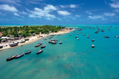
The Gulf of Mannar Marine National Park is a protected area of India consisting of 21 small islands (islets) and adjacent coral reefs in the Gulf of Mannar in the Indian Ocean. It lies 1 to 10 km away from the east coast of Tamil Nadu, India for 160 km between Thoothukudi (Tuticorin) and Dhanushkodi. It is the core area of the Gulf of Mannar Biosphere Reserve which includes a 10 km buffer zone around the park, including the populated coastal area. The park has a high diversity of plants and animals in its marine, intertidal and near shore habitats. Public access inside the park is limited to glass-bottom boat rides.

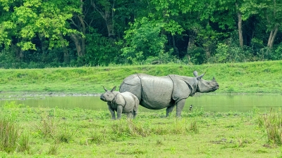
The dugong, a vulnerable marine mammal, is the flagship mammal of the park. It is an important habitat for the cetaceans: Indo-Pacific bottlenose dolphin, finless porpoise, spinner dolphin, common dolphin, Risso’s dolphin, melon-headed whale, and dwarf sperm whale. Larger whales include sperm whale, minke whale, Bryde’s whale, sei whale, and critically endangered species including humpback whale, fin whale, and blue whale.

The islands are uninhabited except for Krusadai, Musal and Nallathanni islands where antipoaching sheds are operating. Along the coast near the park there are about 125 villages which support about 100,000 people who are mainly Marakeyars, a local community principally engaged in fishing.


Picture Credit : Google

Which is the oldest water bird sanctuary in India?

Vedanthangal is the oldest water bird sanctuary in the country. Vedanthangal in Tamil language means ‘hamlet of the hunter’. This area was a favourite hunting spot of the local landlords in the early 18th century. The region attracted a variety of birds because it was dotted with small lakes that acted as feeding grounds for the birds. Realising its ornithological importance, the British government undertook steps to develop Vedanthangal into a bird sanctuary as early as 1798. This was established in 1858 by the order of the Collector of Chengalpattu.

The Vedanthangal Lake Bird Sanctuary features thousands of birds coming from various countries, some of which can be easily identified. Some easily found birds include cormorants, darters, grebes, large egrets, little egrets, moorhens, night herons, paddy birds, painted storks, pintails, pond herons, sandpipers, shovellers, terns, white ibises and many more. The migratory birds include garganeys and teals from Canada; snake birds and glossy ibises from Sri Lanka; grey pelicans from Australia; grey herons and openbilled stork from Bangladesh; painted storks from Siberia; spoonbills from Burma and the spot-billed duck. It is a good tourist spot.

The Vedanthangal lake is situated 122 m above sea level. It supplies water to 250 acres of agricultural land around the area. The west and south sides of the lake are bordered by a long bund, whereas the northern and eastern sides extend to the agricultural lands. Input of water into this lake is through four small canals. Maximum depth of the lake is 5 metres. The area receives an average annual rainfall of 1400 mm, mostly from the north-east monsoon.


Picture Credit : Google

Running north to south along the western edge of the Deccan Plateau, through six States and two Union Territories, which is one of the world’s eight “hottest hotspots” of biological diversity?

The Western Ghats or Sahyadri is a mountain range that runs parallel to the western coast of the Indian peninsula, located entirely in India. It is a UNESCO World Heritage Site and is one of the eight “hottest hotspots” of biological diversity in the world. It is sometimes called the Great Escarpment of India. The range runs north to south along the western edge of the Deccan Plateau, and separates the plateau from a narrow coastal plain, called Konkan, along the Arabian Sea. A total of thirty nine properties including national parks, wildlife sanctuaries and reserve forests were designated as world heritage sites – twenty in Kerala, ten in Karnataka, five in Tamil Nadu and four in Maharashtra.

The mountains intercept the rain-bearing westerly monsoon winds, and are consequently an area of high rainfall, particularly on their western side. The dense forests also contribute to the precipitation of the area by acting as a substrate for condensation of moist rising orographic winds from the sea, and releasing much of the moisture back into the air via transpiration, allowing it to later condense and fall again as rain.  The largest city within the mountains is the city of Pune (Poona), in the Desh region on the eastern edge of the range. The Biligirirangan Hills lie at the confluence of the Western and Eastern Ghats.

There are at least 139 mammal species. Of the 16 endemic mammals, 13 are threatened and amongst the 32 threatened species include the critically endangered Malabar large-spotted civet, the endangered lion-tailed macaque, Nilgiri tahr, Bengal tiger and Indian elephants, the vulnerable Indian leopard, Nilgiri langur and gaur.


Picture Credit : Google

The largest city within the mountains is the city of Pune (Poona), in the Desh region on the eastern edge of the range. The Biligirirangan Hills lie at the confluence of the Western and Eastern Ghats

The Eastern Ghats are a discontinuous range of mountains along India’s eastern coast. The Eastern Ghats run from West Bengal state in the north, through Odisha and Andhra Pradesh to Tamil Nadu in the south passing some parts of Karnataka. They are eroded and cut through by the four major rivers of peninsular India, known as the Godavari, Mahanadi, Krishna, and Kaveri.

The Eastern Ghats are older than the Western Ghats, and have a complex geological history related to the assembly and breakup of the ancient supercontinent of Rodinia and the assembly of the Gondwana supercontinent. The Eastern Ghats are made up of charnockites, granite gneiss, khondalites, metamorphic gneisses and quartzite rock formations.

The southern tropical thorn scrub type forests consist of open, low vegetation that is characterised by thorny trees with short trunks and low, branching crowns that rarely meet to form a closed canopy.

The endemic fauna of the Eastern Ghats are Jerdon’s courser (Rhinoptilus bitorquatus) and grey slender loris (Loris lydekkerianus). The rare geckos found here are Indian golden gecko (Calodactylodes aureus), rock gecko (Hemiphyllodactylus aurantiacus), and Sharma’s skink Eutropis nagarjuni.


Picture Credit : Google
 

The Odisha Cost has three key mass nesting sites of the olive ridleys. One is the Gahirmatha beach, which are the other two river mouths?

Olive Ridley sea turtles turned up for mass nesting this season, after having stayed away from the Rushikulya river mouth on the Orissa coast for two consecutive years. 

Operation Kachhapa has deployed 10 field assistants to monitor the nesting jointly with Forest Department staff. Steps have been taken to protect the nests from predators like dogs and jackals, and also against theft of eggs by local fishermen for consumption.

There are three mass nesting sites in Orissa State. The first, Gahirmatha, in Kendrapara district, is the world’s largest rookery for Olive Ridley turtles. The second, the Rushikulya river mouth rookery, has seen mass nesting since March 1994, when the phenomenon was first discovered at this site.

Operation Kachhapa, under whose aegis a patrol trawler has been provided to the State Forest Department for patrolling the sea in and around the mouth of the Devi river, is engaged in:

  • Building awareness and education by putting up posters, stickers and holding meetings for local fishermen in the coastal villages
  • Empowering the local fisherman community in nearly 120 villages by using travelling minstrels and handbills to enlighten them about marine fishing laws, and how their livelihoods are affected by illegal trawling
  • Providing information to the media about sea turtle activity throughout the season
  • Lobbying the government for protection of the turtles by coast guard patrols and Forest Department patrols
  • Monitoring turtle mortality along the beach (two camps are run, one each at the Devi river mouth and the Rushikulya river mouth)
  • Monitoring turtle nesting sites outside the Sanctuary
  • Providing protection to turtle nests against predators.


Picture Credit : Google

Which national park in Assam is home to the single largest number of one-horned rhinoceros?

Kaziranga National Park of Assam is home to 1,855 adult Indian rhinos and also host one of the highest density of Tigers in India. Kaziranga is a World Heritage Site and hosts two thirds of the world’s great one horned rhinoceroses.

The park also combines high species diversity and recognized as an important bird area. Kaziranga also has significant populations of large herbivores include Elephants, Gaur, Wild water buffalo, 9 primate species, 4 species of wild cats and largest snakes of reticulated python and rock python along with longest venomous King Cobra snake.

Kaziranga is recognized as an Important Bird Area by BirdLife International for conservation of avifaunal species. When compared with other protected areas in India, Kaziranga has achieved notable success in wildlife conservation. Located on the edge of the Eastern Himalaya biodiversity hotspot, the park combines high species diversity and visibility.

Kaziranga has flat expanses of fertile, alluvial soil, formed by erosion and silt deposition by the River Brahmaputra.[citation needed] The landscape consists of exposed sandbars, riverine flood-formed lakes known as, beels, (which make up 5% of the surface area),[citation needed] and elevated regions known as, chapories, which provide retreats and shelter for animals during floods. Many artificial chapories have been built with the help of the Indian Army to ensure the safety of the animals. Kaziranga is one of the largest tracts of protected land in the sub-Himalayan belt, and due to the presence of highly diverse and visible species, has been described as a “biodiversity hotspot”. The park is located in the Indomalayan realm, and the dominant ecoregions of the region are Brahmaputra Valley semi-evergreen forests of the tropical and subtropical moist broadleaf forests biome, and the frequently-flooded Terai-Duar savanna and grasslands of the tropical and subtropical grasslands, savannas, and shrublands biome. Kaziranga is also surrounded by lush green tea plantations, most of them contributing heavily to Assam’s economy.


Picture Credit : Google