Category Science

What is AQI?

Don’t we often come across news about air pollution in our city or surrounding areas and the frequent mention of AQI? But what does AQI stand for and how is it helpful to us? Come, let’s find out

AQI is the abbreviation of Air Quality Index. It is a yardstick that shows us how clean or hazardous the air we breathe in in a particular region is. It is a numerical representation of the air quality in a place, which is determined by measuring the level of pollutants present in the air.

Health concerns

With a rapidly growing population and corresponding economic development, India has been grappling with the issue of air pollution for several decades now, leading to health and environmental concerns. Several factors are responsible for the poor air quality in most parts of the country. While natural sources of air pollutants include smog, storms, dust, and wildfires, we humans are responsible for emissions from factories, automobiles, construction activities, stubble burning, fossil fuel burning, etc. These are responsible for the presence of major air pollutants in the country such as particulate matter (PM2.5, PM10), carbon monoxide, nitrogen oxide, etc.

Exposure to air pollution may lead to severe respiratory illnesses, irritation in the eye, heart disease, and even premature death. Air pollution reduces visibility on the road and may lead to accidents and loss of lives. Besides, it can have a deleterious impact on the environment, damaging crops and trees, affecting yields, causing acid rain, etc.

Launched in 2015

India is home to some of the most polluted cities in the world. In order to address the widely prevalent air pollution crisis, the Government has taken several initiatives. One such is the National Air Quality Index which was officially launched in April 2015 in New Delhi. The NAQI was developed by IIT-Kanpur scientists along with the Central Pollution Control Board. It has been designed to disseminate air quality information to the people. The AQI shows eight pollutants, namely PM2.5, PM10, ammonia, lead, nitrogen oxides, sulphur dioxide, ozone, and carbon monoxide.
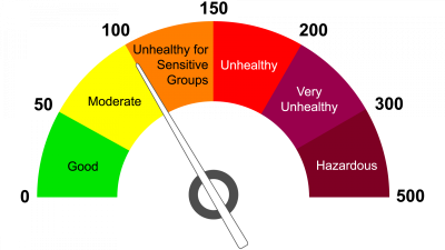
Colour-coded index

 The colour-coded AQI helps people and the administration understand the condition of the air by providing real-time information on air quality. The index converts data of various pollutants collected from monitoring stations into a single number, name, and colour. The AQI value runs from 0 to 500. There are six AQI categories, namely Good (0-50, green), Satisfactory (51-100, light green), Moderately polluted (101-200, pink), Poor (201-300, yellow), Very Poor (301-400, red), and Severe (401-500, dark red), with each being decided based on the concentration values of air pollutants and their likely health impacts. The higher the AQI value, the greater the level of air pollution and the greater the health concern. An AQI value of 50 or below represents good air quality, while an AQI value over 300 represents very poor air quality. There are smartphone apps such as Sameer and SAFAR and websites.

Picture Credit : Google 

How can I invest in our planet?

Earth Day, celebrated each year on April 22, just went by. With “Invest in Our Planet” as the theme, the focus is on engaging governments, institutions, businesses, and people across the world to do their part. And, this includes dedicating time, resources, and energy to solving the climate crisis. What role can we play in this? Here’s what!

Population, a concern

While there are many factors impacting the condition of our planet, one significant aspect is our population. According to the recent UN world population dashboard, India has surpassed China to become the world’s most populous nation with 142.86 crore people as against China’s 142.57 crore. When a country’s population increases, one of its most important benefits is the potential for economic growth. But a spike in population also has negative environmental implications. When the number of people in a country increases, it becomes more difficult to reduce carbon and methane emissions. Not just that, more number of people means more space required for living and more mouths to feed. This could translate to forests being cut down-for meeting both housing and farming needs. When forests go, habitats do too, and along with them the flora and fauna of the region. Apart from food and housing, people’s necessities, comforts, and luxuries also use up natural resources – more the number, faster the depletion of resources. A growing population also leads to a higher amount of pollution – in air, water, and land. This pollution affects not just humans but also animals and plants. In a world already grappling with climate change, population increase too adversely affects our environment.

What can we do?

Individual efforts can be as fruitful as collective ones. There’s so much we can do alone and as a community to be invested in the planet we call home. Here’s a glimpse into a few ways in which we can be kinder to the Earth

• Plant native saplings in your neighbourhood

• Make conscious efforts to reduce the use of plastic

• Take a pledge to choose a sustainable lifestyle

• Plan regular awareness campaigns on local environmental issues

• Conduct river and beach clean-up programmes

• Invite environmentalists and conservationists for talks

Picture Credit : Google 

How do cell phones work?

Also do you know why mobile phones are called cellular phones? Read on to find out…

A cellular phone is similar to a radio. However cell phones allow you to speak and listen at the same time because two separate frequencies are used to transmit and receive signals.

Cellular phones are also similar to cordless phones, which use a pair of frequencies for communication between the base unit and the handset. In the case of cellular phones, the base unit is located a much greater distance away from the mobile phone and is also capable of handling communications with several mobile units at a time.

Within a city, the phone company divides the area into small units called cells. It is for this reason that mobile phones are called cellular phones. In each cell, a tower is installed which has a radio transmitter and receiver, which is capable of communicating with several phones at a time. Each of these cells has a radius of about a couple of kilometres.

When one starts a telephone conversation, the mobile unit will communicate with the base unit in the cell that is nearest. This is similar to the operation of a cordless phone. If you are close to the base unit within a cell, the signal strength will be sufficient to carry on a conversation comfortably. However as one moves away from the base unit, the signal strength will reduce. The base unit senses this reduction in signal strength. Simultaneously, the adjoining cell detects that the signal strength from your phone is increasing and therefore you are moving closer to it. When the signal to the second cell becomes greater than that from the first cell, the conversation automatically switches to the second cell.

In addition every cell phone company will have one central office, which handles communication between the cell phones and ordinary landlines.

For good communication over an entire city, it is important to have a large number of cells, which overlap slightly. This will ensure that there is coverage at all points of the city and also that the communication is uniform. A larger number of cells allow the use of lower power transmitters, and results in less interference.

Picture Credit : Google 

What is a planet beyond our solar system called?

A planet beyond our own solar system is referred to as an exoplanet. While most exoplanets orbit other stars, there are also free-floating exoplanets, called rogue planets, that are not tethered to any star and orbit the galactic centre.

“Blind” surveys

Traditionally, ground-based means have been employed to detect exoplanets. Astronomers use “blind” surveys to look for stars in the sky with the potential for housing giant planets, which can then be directly imaged from Earth based on the stars age and distance. This technique, however, has a very low yield, meaning that exoplanets are detected very infrequently. Astronomers have developed a new technique to detect exoplanets whose portraits can be taken using large ground-based telescopes on Earth. They have tasted success with this method and the result is the direct image of a Jupiter-like gas giant – HIP 99770 b-132.8 light years away in the Cygnus constellation. The study behind this success was published in the journal Science in April.

Combining astrometry and direct imaging

HIP 99770 b is the first exoplanet detected by combining astrometry and direct imaging. While two observatories on Hawaii Island did the direct imaging, the astrometry- responsible for measuring the position and motion of HIP 99770 b’s home star – came from Gaia space observatory and its predecessor Hipparcos.

Precision astrometry is the method of detecting the movement of stars. This allows researchers to identify those stars that are tugged at by the gravitational pull of an unseen companion like a planet. A picture of the star systems that are close enough is then captured to directly image.

The detection of HIP 99770 b serves as proof of a concept developed by an international research team. They were also able to determine that this exoplanet is 14-16 times the mass of Jupiter and orbits a star that is almost twice as massive as our sun. It receives a similar amount of light as Jupiter as its host star is far more luminous than the sun. The team characterised the nature of HIP 99770 b’s atmosphere and showed that the planet’s atmosphere has signs of water and carbon monoxide.

This new method of searching for exoplanets is believed to be a major improvement to the existing, traditional method of “blind” surveys. The researchers also hope that this new approach would lead to further advances that eventually lead to the discovery of an Earth-twin around a nearby star.

Picture Credit : Google 

How do oceans play an important role in ecology?

Oceans cover more than two-thirds of Earth. Understandably, they play a vital role in keeping all life forms going. World Oceans Day (June 8) just went by, reminding us that an important natural resource is in need of our urgent support.

The importance of ocean

Initially, our ancestors were nomads, moving from one place to another. However, they eventually started settling in one place invariably around waterbodies such as rivers, lakes, oceans, etc. For thousands of years, oceans have been the backbone of human survival. But for even longer, they have been inevitable for all life forms, from the tiniest to the largest. All living beings, even those on land, are directly or indirectly dependent on the ocean for their very existence.

We all breathe easy because all oceans together produce at least 50% of the planet’s oxygen. Due to their sheer size, oceans distribute heat from the Equator to the Poles, regulating the world’s climate. Without this, different regions will constantly experience only extreme weather. Marine life is a good source of food for both humans and animals the world over. In addition, some also have medicinal properties. Oceans are also crucial for global economy since they help in transport and tourism.

What is ailing them?

Oceans face several threats today. Thanks to global warming, our oceans are warming too. This affects marine life since many cannot survive warmer waters. When a few species struggle, they can affect others that are dependent on these species, and this can result in ecosystem collapse. Further, warming waters can increase sea levels, resulting in natural disasters. Human activities such as overfishing, plastics, polluted wastewater discharged into the oceans, etc. affect the natural balance in a marine ecosystem.

According to the U.N., “With 90% of big fish populations depleted, and 50% of coral reefs destroyed, we are taking more from the ocean than can be replenished.” The U.N. calls for us to work together in such a way that we not just take less from the oceans but help these natural resources flourish.

The theme for 2023

The theme this year is “Planet Ocean: tides are changing”. The United Nations will work with people from different walks of life – from policy-makers, indigenous leaders, and scientists to private sector executives, citizens, and youth activists to turn the spotlight on oceans.

What is the 30 X 30 target?

At the 2022 United Nations Climate Change Conference or Conference of the Parties of the UNFCCC, more commonly COP27, held in Egypt last November, as many as 112 nations took an important pledge. They promised to take steps for protecting at least 30% of Earth’s land and ocean by 2030 to help curtail biodiversity loss and climate change.

Did you know?

  • The ocean is key to our economy with an estimated 40 million people being employed by ocean-based industries by 2030.
  • Oceans absorb about 30% of carbon dioxide produced by humans, buffering the impacts of global warming.

Picture Credit : Google 

What is the long green belt initiative?

Have you heard about the Great Green Wall? The African-led initiative aims at restoring the continent’s degraded landscapes by creating an 8000-km-long belt of greenery across the Sahel, the region bordering the Sahara desert. Read on to find out interesting details about the project.

Regenerating the Sahel

The Sahara, the world’s largest hot desert located in North Africa, has expanded 10 per cent southwards into the Sahel since 1920.

The Sahel is a vast semi-arid region separating the Sahara from the tropical savanna grasslands to the south. It is mostly barren, with sandy, rock-strewn and degraded landscapes. It stretches from Senegal in the west to Eritrea in the east, and cuts through more than a dozen countries in between. It is also one of the world’s poorest regions.

The people who live in the Sahel are regularly beset by drought and famine. Overgrazing, increasing population and poor farming techniques have added to the problems.

Great Green Wall

In 2007, the African Union, made up of all 54 countries in the continent, decided to do something about regenerating the Sahel. It launched an ambitious project called the Great Green Wall, an 8000-km-long belt of greenery that would encircle the waist of Africa! The plan was to plant millions of trees across the Sahel to hold back the Sahara.

The Wall aimed to revitalise 100 million hectares (247 million acres) of degraded land, sequester 250 million tons of carbon, and create 10 million jobs in rural areas by 2030. Completed, it would be Earth’s most massive living structure. It was also expected to benefit the communities living in the Sahel and reduce conflict over land and migration due to drought.

It began with 11 countries, which later increased to 20, and then 26. In some countries, many of the planted trees died, either because they were not the suitable species for that region or because they were attacked by pests. Trees planted in remote, sparsely inhabited areas also perished. In many cases, the locals were not motivated enough and lost interest in looking after the trees. It turned out that constructing a wall of trees was not child’s play.

Indigenous methods of land use

The project leaders decided that each country would work according to its own plan and adapt indigenous methods of land use, such as soil conservation and rainwater harvesting that were already being followed by farmers and landowners. In some places, grasses and not trees were planted. In others, it was a mix of both. Hardy native species that were resistant to insects were chosen. For instance, the Sahel’s acacia trees became one of the staple plants. Its sap, called gum arabic, is used in a range of products, from paints and cosmetics to candies and sodas. The export of gum arabic became a steady source of income for the locals.

The project has had patchy success, depending on the country, its capacity to invest money and the enthusiasm of its farmers. Ethiopia began reforestation early and has so far planted more than 5 billion seedlings on 150,000 hectares of land. Burkina Faso, Nigeria, Niger, Senegal and Chad have also reforested large swathes of degraded land, planting trees numbering in the millions. Countries like Cameroon and Ghana were slower off the blocks.

Roughly 49 million acres were restored between 2007 and 2018 at a cost of more than $200 million. More than 20 million acres of land need to be restored every year and over $4 billion invested annually, if the Wall is to be finished by 2030.

However, the project has created more than 350,000 agroforestry jobs and generated $90 million in revenue in the countries where it has been implemented, giving them an incentive to soldier on.

INDIAN INITIATIVE

Africa’s Great Green Wall has inspired our own government to create a 1,400-km-long and 5-km-wide ‘green belt’ from Gujarat to the Delhi Haryana border, from Porbandar to Panipat. The plan hopes to reforest degraded land along the Aravalli Hills that will also act as a barrier to the shifting sands of the Thar Desert.

DID YOU KNOW?

* In 1996, 197 nations came together to ratify the United Nation’s Convention to Combat Desertification.

* More than 24 billion tons of fertile soil is still lost yearly to desertification, while 40 per cent of the Earth’s land surface is now considered degraded. Dry land degradation affects the economies of developing countries. The UN estimates that desertification impacts 3 billion people on Earth.

*Desertification cannot be blamed only on deserts! Similar to climate change, human activities are often the main cause of land degradation. Intensive agriculture, overgrazing by livestock, industries set up in remote areas, an exploding population and increasing urbanisation-all have led to desertification.

Picture Credit : Google