Category The World Around Us

Which is the largest lake in South America?

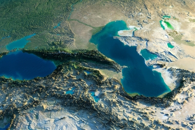
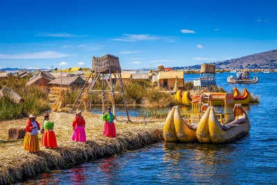
Lake Titicaca is the largest lake in South America by surface area and volume. It covers an area of 3,232 sq mi and holds an average of 214 cu mi of water. It is the world’s “highest navigable lake” at an altitude of 12,507 ft. Titicaca is located within the boundaries of two countries; the western part lies in Puno Region of Peru while the eastern part is located in the Bolivian La Paz Department. The lake consists of two basins connected by the Strait of Tiquina. Five major rivers and more than 20 streams feed Titicaca; the Río Desaguadero is the only outlet. There are 41 islands on the lake most of which are inhabited.

The lake averages between 460 and 600 feet (140 and 180 m) in depth, but the bottom tilts sharply toward the Bolivian shore, reaching its greatest recorded depth of 920 feet (280 m) off Isla Soto in the lake’s northeast corner.

More than 25 rivers empty their waters into Titicaca; the largest, the Ramis, draining about two-fifths of the entire Titicaca Basin, enters the north-western corner of the lake. One small river, the Desaguadero, drains the lake at its southern end. This single outlet empties only 5 percent of the lake’s excess water; the rest is lost by evaporation under the fierce sun and strong winds of the dry Altiplano.


Picture Credit : Google

Which is the largest lake in North America?

The largest lake in North America is Lake Superior. The lake’s name did not initially refer to its enormous size, but was described as “la lac superior” by early French explorers in reference to the fact that it was the only lake upstream from the other Great Lakes of North America. However, in the 1760s the British anglicized the lake’s name to Lake Superior in reference to its massive size. Lake Superior is the largest freshwater lake in the world and covers a total area of 82,100 square miles.

Like all of the Great Lakes, Lake Superior is prone to lake effect snow, but the weather is generally moderate, with warmer temperatures than inland throughout the year. Winter temperatures around the lake rarely fall below minus 30 F (minus 34 C), well above inland temperatures. June and July are calm months, while October and November are prone to storms.

During most winters, the lake is 40 to 95 percent covered with ice, although it rarely completely freezes. The last time Lake Superior froze over was in 2014. Overall, the Great Lakes reached a 91 percent ice cover that year, which is the most the lakes have frozen since 1979. Freezing of the lakes is monitored because it affects hydropower generation, commercial shipping, the fishing industry and more, according to the Office of Oceanic and Atmospheric Research.


Picture Credit : Google

Which is the largest lake in Africa?

Lake Victoria is the largest lake in Africa.

It straddles the borders of Uganda, Kenya, and Tanzania. It was once thought to be the source of the Nile River since the Nile is the only river flowing out from Lake Victoria.

Lake Victoria has some specialized flora and fauna found nowhere else in the world. Many of these species have become extinct in recent decades. This is due to the introduction of invasive species like the Nile perch. Nile perch can grow to be larger than the size of a full-grown man.

A parasite known as Bilharzia makes swimming in Lake Victoria a risk. Bilharzia is found in many African lakes. It is easily treated, but it’s best to have the medication on-hand if you plan to swim.

Some larger threats lurk under the waves. It’s becoming more common to hear about attacks from hippopotamus or the Nile crocodiles since much of their smaller pray have been hunted away.


Picture Credit : Google

Which is the largest lake in Asia?

The Caspian Sea is the Earth’s largest inland body of water. It lies at the junction of Europe and Asia, with the Caucasus Mountains to the west and the steppes of Central Asia to the east. It is bordered by Russia to the northwest, Azerbaijan to the west, Iran to the south, Turkmenistan to the southeast and Kazakhstan to the northeast. 

“The Caspian Sea is located in a dry region of the world,” Kukral told Live Science. Nevertheless, during harsh winters its entire northern half can freeze. 

The Caspian Sea is endorheic, meaning it has no natural outlets. More than 130 rivers flow into the Caspian Sea, according to Natural History Magazine, none of which are in the east. The primary tributary is the Volga River in the north, which provides about 80 percent of the inflowing water. The Ural River, also in the north, and the Kura River in the west, are also significant tributaries. The inflowing fresh water from these rivers dilute the water. Salinity changes from north to south, from 1.0 to 13.5 parts per thousand (ppt), according to Casp Info, a data-management project about the Caspian Sea funded by the European Union. By contrast, the North Atlantic Ocean has a salinity of 37 ppt, according to Encyclopedia Britannica.  

The most famous and financially valuable animal in the region is the beluga sturgeon, sometimes called the European or Caspian sturgeon. The world’s largest freshwater fish, the beluga sturgeon is known for its eggs, which are processed into caviar. The majority of the world’s beluga caviar comes from the Caspian Sea. This has caused problems with overfishing. Dams have also destroyed much of their spawning grounds, and pesticides used in land agriculture have limited their fertility. The beluga sturgeon is now critically endangered, according to the World Wildlife Fund. 


Picture Credit : Google

Which is the largest desert in Australia?

The Great Victoria Desert (GVD) forms one of nine distinct sub-landscapes in the Alinytjara Wilurara region. It is the largest desert in Australia, spanning over 700 kilometres. Its pristine, arid wilderness includes red sand dunes, stony plains and dry salt lakes.

The desert is a part of Australia that houses the most populous and healthy population of Indigenous Australians belonging to groups like Pitjantjatjara, Mirning, and the Kogara. Large parts of the Great Victoria Desert, however, remain uninhabited as the climate and terrain are unsuitable for human settlement. Large, pristine areas of the desert are protected areas like the Mamungari Conservation Park.

Only drought resistant plants can survive the harsh desert environment. A few species of Acacia and Eucalyptus can be found here. Spinifex grasses occupy most the of the desert landscape amidst the sandy ridges. A few mammals and birds can be found in the Great Victoria Desert. Some examples are the great desert skink, the crest-tailed mulgara, the southern marsupial mole, the sandhill dunnart, etc. The large monitor lizards, the sand goanna and the perentie, and the dingo are the active predators of the Great Victoria Desert.


Picture Credit : Google

Which is the largest desert in Europe?

Oleshky is the largest desert in Europe and it’s in an unusual place seeing as Ukraine is well-known for its rich agricultural land. In the 19th century, this area in the Kherson region was overused by sheep farmers and the grass gave way to sand which has reigned ever since. To stop the spreading desertification, the largest tree planting operation in history was carried out in the 20th century around the sand’s borders – 100,000 hectares of new trees! Oleshky is popular with visitors but some parts are considered no-go – landmines were left behind in certain areas during military exercises in the Soviet era.

As any desert, the Oleshky Sands have their own oases, dried up, wet, and mineral lakes, and 5 m high sand dunes covered with grass and bushes. Sandstorms are known to occur in these regions. In order to prevent the whole Black Sea region from turning into one big desert, in the 20th century, artificial forests were planted around the sands. Today, spreading over a territory of 100,000 hectares, these forests are one of the largest artificial forests in the world.

The sands are thought to be formed during the most recent ice age by aeolian processes accumulating and forming cliffs of lower parts of nearby river Dnieper. It is speculated that the number of vegetation was reduced by herds of sheep who were introduced there by Eduard von Falz-Fein who used the sands, formerly populated by weeds, as a pasture.


Picture Credit : Google

Which is the largest desert in Antarctica?

The largest desert on earth is the Antarctic desert, covering the continent of Antarctica with a size of around 5.5 million square miles. The term deserts includes polar deserts, subtropical deserts, cold winter and cool coastal deserts, and are based on their geographical situation.

Like most global deserts, the Antarctic covers the entire continent. In fact, an astonishing 98 percent is permanently covered by a sheet of ice. It is considered a desert because it rains on average only 10 mm every year. Some experts even believe that certain parts located away from the coast have not had rain in the past 14 million years.

It’s covered by a permanent ice sheet that contains 90% of the Earth’s fresh water. Only 2% of the continent isn’t covered by ice, and this land is strictly along the coasts, where all the life that is associated with the land mass (i.e. penguins, seals and various species of birds) reside. The other 98% of Antarctica is covered by ice which averages 1.6 km in thickness.

There are no permanent human residents, but anywhere from 1,000 to 5,000 researchers inhabit the research stations scattered across the continent – the largest being McMurdo Station, located on the tip of Ross Island. Beyond a limited range of mammals, only certain cold-adapted species of mites, algaes, and tundra vegetation can survive there.


Picture Crdit : Google

Which is the largest desert in South America?

 The Atacama Desert is on the other side of Eastern Patagonia. Therefore, you will find that it is surrounded by the Andes in its eastern part and by the Pacific Ocean in the west. The Atacama Desert is known as the driest non-polar place in the world. It could be several years without rain in one of the largest deserts in South America.

The desert occupies an area of about 105,000 square km. Large sections of the desert feature salt lakes, sand, felsic lava, and stony terrain. The Atacama Desert is known to be the world’s driest non-polar location. In the central sector of the desert, rainfall often does not occur for periods of up to four or five years. The species diversity of the Atacama Desert is highly restricted. Some parts of the desert are too dry to sustain any life form at all. Scorpions, desert butterflies, and wasps, the Atacama toad, lava lizards, iguanas, etc., are some of the Atacama Desert fauna. Birds visiting or residing in the desert include sparrows, hummingbirds, Andean flamingos, Humboldt penguins, etc. Seals and sea lions can be sighted along the coast.

Much of the Atacama Desert’s core is caked in thick salt deposits called playas, which can stretch for miles and are nearly half a meter thick (1.6 feet) in some places. The desert is speckled with stones that have been carried across the playas by powerful wind gusts. Alluvial fans, which are large, fan-shaped sediment deposits, connect the desert plateau with the mountains that surround it and suggest that water once flowed from the Andes into the desert.


Picture Credit : Google

Which is the largest desert in North America?

The Chihuahuan Desert is the largest hot desert in North America, located in the Southwestern United States and Northern Mexico. Its total area is 140,000 sq mi (360,000 km2).

Though the Chihuahuan Desert is the southernmost, it lies at a fairly high elevation and is not protected by any barrier from arctic air masses, so hard winter freezes are common. Its vegetation consists of many species of low shrubs, leaf succulents, and small cacti. Trees are rare. Rainfall is predominantly in the summer, but in the northern end there is occasionally enough winter rain to support massive blooms of spring annuals. The Chihuahuan Desert is unexpectedly rich in species despite the winter cold.

The eastern boundary of the Chihuahuan Desert is one of the oldest and richest centers of plant evolution on the North American continent. A wide variety of vegetation communities are present in the in the ecoregion, ranging from desert shrublands at lower elevations and conifer woodlands at the highest elevations. The Chihuahuan Desert boasts as many as 3,500 plant species, including nearly a quarter of the world’s cactus species. Approximately 1,000 of the plant species grow only in this ecoregion. Some distinctive habitat types in the Chihuahuan Desert include yucca woodlands, playas, gypsum dunes, and a diverse array of freshwater habitats. Vast desert grasslands and a wide variety of yuccas and agaves, including many endemic species, also make this desert extremely unique.

The Chihuahuan Desert is home to more than 170 species of amphibians and reptiles. At least 18 of these species are endemic to the Ecoregion. There are a surprisingly large number of endemic fish that occur in the Chihuahuan Desert as well—nearly half of the 110 fish species in the region are either endemic or of limited distribution. Most are relic species found in isolated springs in the closed basins.


Picture Credit : Google

Which is the largest desert in Africa?

The Sahara is one of the harshest environments on Earth, covering 3.6 million square miles (9.4 million square kilometers), nearly a third of the African continent, about the size of the United States (including Alaska and Hawaii). The name of the desert comes from the Arabic word ?a?r??, which means “desert.”

The Sahara desert has a variety of land features, but is most famous for the sand dune fields that are often depicted in movies. The dunes can reach almost 600 feet (183 meters) high but they cover only about 15 percent of the entire desert. Other topographical features include mountains, plateaus, sand- and gravel-covered plains, salt flats, basins and depressions. Mount Koussi, an extinct volcano in Chad, is the highest point in the Sahara at 11,204 feet (3,415 m), and the Qattara Depression in Egypt is the Sahara’s deepest point, at 436 feet (133 m) below sea level.

Camels are one of the most iconic animals of the Sahara. The large mammals are native to North America and eventually made their way across the Bering Isthmus between 3 and 5 million years ago, according to a study in the Research Journal of Agriculture and Environmental Management in 2015. Camels were domesticated about 3,000 years ago on the Southeast Arabian Peninsula, to be used for transportation in the desert, according to the University of Veterinary Medicine, Vienna.

Plant species in the Sahara have adapted to the arid conditions, with roots that reach deep underground to find buried water sources and leaves that are shaped into spines that minimize moisture loss. The most arid parts of the desert are completely void of plant life, but oasis areas, such as the Nile Valley, support a large variety of plants, including olive trees, date palms and various shrubs and grasses.


Picture Credit : Google