Category The World Around Us

Where do boats begin and end their voyages?

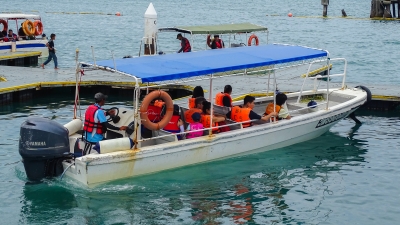
You’re at a place where there are lots of things to see, hear, smell, and taste. You can hear the cawing of hungry sea birds.

You can see boats loading and unloading, tiny tugboats pulling enormous ships, and sailors getting ready for a cruise. Where are you? At a harbour!

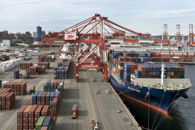
Boats and ships begin and end their voyages at a harbour. A harbour is a protected body of water. Some harbours are partly surrounded by land. The land protects them from dangerous ocean waves and strong winds. Other harbours are built near narrow channels of water. On open coasts, huge walls are built to protect a harbour.

At a harbour, you might smell the salt air and motor fuel. At small harbours, people dock and refuel their boats. These harbours may have ramps that people use to unload the boats from car trailers. Other harbours are big enough to hold many large ships and barges.

Clang clang clang. The captains of boats and ships carefully move their vessels around the clanging coloured buoys. The buoys warn them of dangerous places, such as shallow, water and rocks.

If you are lucky, the harbour might even have a snack bar with delicious seafood to taste!


Picture Credit : Google

How do people travel on sand?

All is quiet except for the tinkling of harness bells and the shifting of sand, as the great animals lift their feet. Everywhere you look there is sand – as far as the eye can see. There is no road to follow, not even a track, but a string of camels winds its way across the vast desert.

A string of camels carrying goods is called a caravan. Camel caravans are still a common sight in many of the world’s deserts. But, small aeroplanes and sturdy all-surface vehicles are now used in some desert places.

A camel caravan may make its way to Timbuktu in Mali, western Africa. Timbuktu is near the southern edge of the Sahara. Every year from December to May, great camel caravans gather there. People come from many places to trade goods.

The camel is the ideal animal to use for transport in a desert, because its wide feet do not sink into the sand. Also, camels can go for several days without water and use fat in their humps to keep them alive. If you think the desert seems like an ocean of sand, you can see why camels are often called “ships of the desert”.


Picture Credit : Google

How do people travel across water?

Some of the first boats were made thousands of years ago by the ancient Egyptians. They built their boats out of a reed-like plant called papyrus.

Today, the same kind of boat making still goes on. Some people cut tall reeds. They bend and weave them into fishing boats.

Other people build long, thin boats called canoes. They build or carve the boats from wood. Both kinds of boats are very light and can be carried across the mud to the river’s edge.

Today, many boats are complicated machines. They are built to go on long journeys in any kind of weather, and they often carry heavy loads.

Ferries are like taxis, they carry people and sometimes cars across a body of water.

Ocean liners are much bigger. They carry people across an ocean, sometimes travelling for many days.


Picture Credit : Google

How do people travel across snow and ice?

In Canada, winters are long and cold. In some parts of the country, deep snow covers the ground for months at a time, and it is hard to go from place to place. Some of Canada’s people have solved this problem by using sleds pulled by dogs.

The sleds are useful, but today, some people use snowmobiles to move heavy loads. A snowmobile is a kind of sled on skis, with a motor to push it through even the thickest snow. The driver uses handlebars to steer the snowmobile.

Another way of moving through frozen places is to put on skates. People travel on skates across ice in cold northern countries, such as Finland, Norway, Sweden, and Russia.

The Lapps of northern Europe use both old and new ways to cross the snow-covered ground. Some use skis to travel with their herds of reindeer, while their belongings are strapped onto a sled pulled by reindeer. Others use snowmobiles, and some even use helicopters.


Picture Credit : Google

Why people ride cars and motorcycles?

Before cars were invented, people walked, cycled, rode animals, or rode vehicles pulled by animals to work or to visit friends and family. So people usually lived near their work and family.

The invention of the car allowed people to live further away from their work. Today, cars zoom over roads and motorways to take people to work. Cars also take people to the homes of friends and family. Many people drive to holiday spots such as theme parks, national parks, mountains, or seashores.

There are more than 650 million passenger cars in the world. While cars help people in many ways, they cause problems, too. These problems include accidents, pollution, and frustrating traffic jams. Many people try to help by giving lifts to other people. Some countries have special motorways where one lane is only for cars with more than one person in them.

In some countries, motorcycles are a popular way to get to work. Most motorcycles are less expensive than cars and take up less space. Many police officers use motorcycles because they are small enough to move easily through traffic.

Some cars are able to give directions! Cars that can do use GPS (Global Positioning System) technology. GPS can track the location of a car using a satellite. A device installed in the car allows it to map out a route based upon the car’s location.


Picture Credit : Google

Why are there roads?

The road zigzags further and further upwards. You peer out of the car window and gulp as you look back. It’s a very long way down!

You are travelling over a mountain pass in the South Tyrol, Austria. It is too steep to go straight up, so the roads to the top wind backwards and forwards like a slithering snake.

Today, there are roads across all the countries of the world. Some are little more than dirt tracks, and others are six-lane or eight-lane motorways that carry heavy traffic in each direction.

Roads of some sort have existed for thousands of years. Often a road started as a rough track – the easiest route from one place to another. Over the years, the feet of people and animals wrote it down until it became a smooth, wide path. As towns grew, the paths became wider still. Some were covered with gravel, pebbles, or other materials to make them permanent roads.


Picture Credit : Google

How people of different continents are connected to each other?

The seven continents are far apart from each other, but they are all part of the earth. No matter how far apart the continents are, the people who live on them are connected because they have the same needs. In addition to needing food, clothing, and a place to live, they all need to learn, to communicate, and to plan for the future.

Years ago, people knew very little about the continents. The only way they could learn about them was by travelling on ships. Today, TV’s and computers send information around the world with the flick of a switch or the click of a mouse. People watching TV in Australia can see a person rafting down the Amazon River in South America. A scientist in North America can send an instant message to a scientist in Antarctica by computer.

Yes, the continents are very far apart. But transport and technology have brought the people who live on them much closer together.


Picture Credit : Google

Which is the largest lake in Australia?

Lake Eyre, officially named Kati Thanda-Lake Eyre, is a large salt water lake in South Australia. The lake derives its name from the first European to discover it, Edward John Eyre. Lake Eyre is mostly dry, but when filled it becomes the largest lake in Australia, occupying an area of 3668 square miles. When Lake Eyre is filled with water, and it springs to life, providing a habitat for migratory birds such as pelicans and sea plants. Lake Eyre falls under two protected areas: Elliot Price Conservation Park and Kati Thanda-Lake Eyre National Park. The South Australian government protects the area surrounding the lake.

The water entering Lake Eyre comes mostly from the rivers from the northeast (in Queensland), which flow down from the Channel Country. A smaller amount of water comes down from Northern Territory from the Finke River catchment, via the Macumba River.

Generally, it takes around 6-8 weeks for water from the Channel Country to reach the lake.

One of the more disturbing facts is that as water fills the lake, the salinity increases and causes a massive fish kill. (Yes, there are about 6 or 7 species of fish which live in the lake!).

Once the lake is full, however, it’s no more salty than the sea. As the lake dries up and the water evaporates, its salinity increases again.

During this time Lake Eyre often appears to turn ‘pink’. This is in fact caused by a pigment found within an algae species that lives in the lake.


Picture Credit : Google

Which is the largest lake in Europe?

Ladoga is by far Europe’s largest lake with a total surface area of 17 700 square kilometers (6,800 sq mi), which means that it’s larger than both Onega and Vänern combined. 

It’s beautifully located in Karelia in the northwestern part of Russia. Ladoga is ranked as one of the largest lakes in the world (14th) and has an average depth at 51 meters, and maximum depth at 230 meters. 

Visitors can rent a boat to get around the lake and stop for a picnic at one of the 600 islands that are located within its boundaries.

Lake Ladoga famously serves as a source of drinking water for the city. Renowned vodka brand Russian Standard even uses it to create the nation’s favourite tipple (the word vodka is a diminutive of the Russian ‘voda’, meaning water); the company’s vodka scientists go as far as describing the lake water as ‘being alive’.

History aside, Lake Ladoga is a wonder of Nordic beauty, characterized by dense forests and rocky coastlines that can be explored by boat or on foot. The lake boasts an incredibly diverse ecosystem, with nearly 500 species of fish roaming its waters, including carp, bream, perch, and the endangered Atlantic sturgeon, whose eggs are used to make premium caviar.


Picture Credit : Google

Which is the largest lake in Antarctica?

Antarctica is the world’s southernmost continent and is located almost completely south of the Antarctic Circle. It is also the coldest, driest, and windiest continent, and approximately 98% of Antarctica is covered by ice that has an average thickness of nearly 2 km. Despite being largely covered in ice, Antarctica contains numerous lakes and rivers. Many of these lakes are subglacial. The largest of the 400 known subglacial lakes in Antarctica is Lake Vostok, which is located beneath Vostok Station, a Russian research station in Prince Elizabeth Land, Antarctica. Lake Vostok is a freshwater lake situated approximately 4,000 m beneath surface of the ice sheet, which means it is approximately 500 m below sea level.

Lake Vostok was most likely sealed off by a thick ice sheet approximately 15 million years ago. Researchers initially believed the same water had been in the lake since its formation. However, researchers Robin E. Bell and Michael Studinger from Columbia University’s Lamont-Doherty Earth Observatory later proved that the lake’s water was continually freezing and getting carried away by moving ice sheets, and then replaced by water created through the cumulative pressure of the ice sheets. As a result, the entire lake water is replaced approximately every 13,300 years.


Picture Credit : Google