Category Ecology

WHAT ARE GLACIERS?

The word glacier comes from the French word glace, meaning ice. A glacier is a huge, slow-moving mass of ice. Glaciers are generally seen in mountainous regions where temperatures always remain close to freezing and a massive amount of ice accumulates. Forced by the weight of the ice and the pull of gravity, these sheets of ice start moving, almost like a river, although most glaciers move no more than one  centimetre a day.

Glaciers are massive bodies of slowly moving ice. Glaciers form on land, and they are made up of fallen snow that gets compressed into ice over many centuries. They move slowly downward from the pull of gravity.

Most of the world’s glaciers exist in the polar regions, in areas like Greenland, the Canadian Arctic, and Antarctica. Glaciers also can be found closer to the Equator in some mountain regions. The Andes Mountain range in South America contains some of the world’s largest tropical glaciers. About 2 percent of all the water on Earth is frozen in glaciers.

Glaciers can range in age from a couple hundred to thousands of years old. Most glaciers today are remnants of the massive ice sheets that covered Earth during the Ice Age. The Ice Age ended more than 10,000 years ago. During Earth’s history, there have been colder periods—when glaciers formed—and warmer periods—when glaciers melted.

Scientists who study glaciers are called glaciologists. Glaciologists began studying glaciers during the 19th century in order to look for clues about past ice ages. Today, glaciologists study glaciers for clues about global warming. Old photographs and paintings show that glaciers have melted away from mountain regions over time. Indeed, glaciers worldwide have been shrinking—and even disappearing—at an accelerated rate for the past several decades.

Credit: National Geographic Society

Picture Credit : Google 

WHAT IS THE DEEPEST POINT ON EARTH’S SURFACE?

It’s beneath the surface of the Pacific Ocean to the southeast of Japan. There, you’ll find a deep, crescent-shaped trench. This is called the “Mariana Trench.” Near the southern tip of the crescent, there is a small slot-shaped area. This is the deepest point on Earth—Challenger Deep.

The bottom of Challenger Deep is about 36,000 feet below sea level. That’s nearly seven miles! This makes it the deepest known place on Earth.

The Challenger Deep is named after a British Royal Navy ship called the HMS Challenger. It was the first ship to measure the depths of what is now known as the Challenger Deep. The Marianas Trench in the western Pacific is 11,030 m deep.  

The trench was measured by “sounding.” This involves dropping a very long line with a weight at the end into a body of water. Today, scientists and researchers use sonar to study ocean depths.

Only four descents into the Challenger Deep have ever been achieved. The first was in 1960 by a vessel called the Trieste. The Trieste was a special kind of ship called a “bathyscaphe,” invented by Jacques and Auguste Piccard. The name “bathyscaphe” is taken from the Greek words for “deep” and “ship.”

Credit: WONDEROPOLIS

Picture Credit : Google

WHAT IS THE AVERAGE DEPTH OF OCEANS?

The average depth of the ocean is 3,700 meters (12,100 feet). But the deepest part ever recorded is located in the western part of the Pacific Ocean, in the Mariana Trench, at a depth of around 11,000 meters (36,200 feet).

Bathymetry is the scientific term for measuring the depth of water in oceans, lakes and rivers. Bathymetric maps are similar to land maps in that they show the different underwater landforms in a specific area. Scientists and researchers can use different methods to measure ocean depth.

The different methods are:

1. Sonar

The most common and fastest way of measuring ocean depth uses sound. Ships using technology called sonar, which stands for sound navigation and ranging, can map the topography of the ocean floor. The device sends sound waves to the bottom of the ocean and measures how long it takes for an echo to return. The “echo” is the sound wave reflecting off the seabed and returning to the sonar device.

2. Radar and satellite

Another alternative, though not as fast as sonar, is radar. Similar to sonar, radar requires sending out a type of wave that pings off an object and reflects back. The difference is that radar uses radio waves, a form of electromagnetic wave. But because electromagnetic waves travel slower in water compared with air and become diminished as they travel through water, they are more ideal for atmospheric measurements.

Ocean Depth Measured in the Olden Days

Before the discovery of using sound and radar to measure ocean depth, captains and their crews used a different way to measure the depth of the ocean. Sailors would use a tool called a lead line, which was essentially a lead weight attached to a rope that is marked every 6 feet, a length called a fathom, with a rag or strip of leather. A crew member would then throw the line into the water, and once the lead weight reached the bottom the sailor would measure and record the distance to the ocean floor using the strips on the rope.

The lead line was the most valuable method of measuring depth for navigation and has been used since the fifth century BCE. The tool helped sailors know how deep the water was and if their ship would run aground. The bottom of the lead weight was cupped inward and filled with grease and was used to bring up samples from the ocean floor to help sailors determine if the ocean bed was sand, gravel or mud.

Credit: NIST

Picture Credit : Google

CAN THE DEEP OCEAN FLOOR BE MAPPED?

Ocean floors are mapped using sound equipment and robot submarines. Sonar systems send out high -frequency pulses. The time it takes for the sound pulse to echo back from the ocean floor gives an idea as to the depth of the ocean.

Understanding the depth and shape of the seafloor, called bathymetry, is not only a mapping challenge but it is important if we are to better understand are oceans. This includes understanding ocean circulation, which affects climate, tsunamis, environmental change, underwater geo-hazards, resources, and many other processes affecting the environment, safety, and commerce.

Mapping the seafloor has been occurring since the early 19th century; however, obtaining accurate data has been a challenge until the invention of the sonar. More recent sonars (short fo  Sound Navigation and Ranging) provide far more accurate data, particularly when multibeam echosounder sonars are used.

The Seabed 2030 project is a project attempting to map the seafloor by 2030. Until now, however, only about 20% of the seafloor has been mapped using modern bathymetry methods. In part, the project to map the seafloor will benefit from crowd sourced data obtained from various ocean-going vessels.

However, NOAA is also leading the effort and vessels with sonar equipment are being used to map regions not often travelled by vessels. These vessels are equipped with the latest multibeam sonars that provide hydrographic surveying results that can then build detailed maps with about 0.5 meter resolution.

The mapping efforts are attempting to use different frequencies, from around 12 kHz to closer to 200 kHz, often used in shallower waters. While generally deeper sea levels are easier to map, as sound waves travel and allow a wider region to be surveyed as a ship passes by, shallow areas present challenges, given that multiple passes need to cover less area and interference observed from other sea life and vessels can disrupt data.

Credit: GIS LOUNGE

Picture Credit : Google

WHICH IS THE BIGGEST OCEAN?

The Pacific is the biggest and the deepest Ocean. It covers a third of Earth’s surface and has an area of 180 million km, holding more than 700 million km of water. It is so big that all the continents could fit within its area.

The Pacific Ocean is the largest ocean in the world, making up around 28% of the world’s surface area and almost double that in water surface area. It touches the west coast of North America. It is also home to the deepest trench on earth, the Marianas Trench, where the Challenger Deep is located. It’s 36,037 feet deep, far deeper than Mount Everest is tall. The trench is located between two tectonic plates, accounting for its incredible depth. The ocean’s coast line, along North America and Japan, is prone to earthquakes.

The ocean was named by the explorer Ferdinand Magellan. He chose “pacific” to mean “peaceful sea.” The Pacific Ocean is home to the Ring of Fire, a chain of 450 volcanoes in a u-shape. They reach from South America, along the coast of Japan, the western United States, all the way down into New Zealand. The Pacific Ocean is the world’s largest body of water.

Credit: OCEAN INFO

Picture Credit : Google

WHICH ARE THE MAJOR OCEANS?

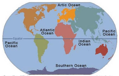
An ocean is a huge, continuous body of salt water. Oceanographers identify five major oceans on the basis of geography and the continents that surround them. These are the Pacific, Atlantic, Indian, Arctic and Southern (also known as Antarctic) Oceans. They cover about one-third of Earth’s surface and contain about 97 per cent of the world’s water.

Pacific Ocean

The Pacific Ocean is the largest ocean covering more than 30% of the Earth. This is close to half of the water on Earth.

It touches the west coast border of the Americas along with east Asia and Australia.

The equator divides the Pacific Ocean into two separate parts – the North Pacific Ocean and South Pacific Ocean.

Pacific means “peaceful” in Latin. It has the deepest trenches with an average depth of 3800m.

Atlantic Ocean

The Atlantic Ocean is situated between the Americas and European/African continents. The Atlantic Ocean is the second-largest and saltiest ocean in the world.

It resembles an S-shape between the Americas, Europe, and Africa. “Atlantic” originated from the Greek god “Atlas” who carried the sky for eternity.

The ocean bottom is composed of mid-Atlantic Ridge. This submarine mountain range extends all the way from Iceland to 58 degrees South latitude. It’s part of the longest mountain range in the world.

Indian Ocean

The Indian Ocean is the third largest ocean surrounding a densely populated region. It contains an additional 20% of the water on Earth’s surface.

It borders India in the North, East Africa, Australia, and the Southern Ocean. Because of the higher water temperature, it has limited marine life.

Since about 800 A.D. the Indian Ocean has played an important role in trading. For centuries, navigators have sailed along major ocean currents for shipment routes.

It is bounded by 4 tectonics plate boundaries and may include an additional plate boundary. It is the geologically youngest of the 5 oceans with spreading ridges at divergent plate boundaries.

Southern Ocean

In 2000, the Southern Ocean is the newest ocean recognized by the International Hydrographic Organization. It borders Antarctica in its entirety.

In terms of size, it’s the fourth-largest at 20,327,000 square kilometers. It extends out to 60 degrees South latitude.

It’s an extreme environment and is the least understood of the 5 oceans. This is because it is unexplored, far from populated areas, and has a severe climate.

Despite the Southern Ocean being unexplored, about 80% of all oceans in the world are unexplored. There’s still a lot of work to do for ocean exploration.

Arctic Ocean

The Arctic Ocean is the world’s smallest and shallowest ocean of all 5 oceans. Further to this, it is the coldest and least salty ocean.

In size, the Arctic Ocean is about the size of Russia. Because it’s located at the North Pole, the Arctic Ocean has polar ice. But over the years, glaciers have melted threatening sea levels to rise.

Despite the IHO recognizing it as the “Arctic Ocean”, some oceanographers still call it the “Arctic Sea”.

The Arctic Ocean is the most diverse in terms of fish species. It has a wide variety of marine species including whales, jellyfish, etc.

But because of its frigid temperatures, it has little plant life. This makes it one of the most fragile ecosystems on the planet.

Credit: EARTHHOW

Picture Credit : Google