Category Geography

WHERE IS THE ANTARCTIC CIRCLE?

The Antarctic Circle is a parallel of latitude on the Earth at approximately 66.5 degrees south of the equator. On the day of the southern summer solstice (around December 22 each year), an observer on the Antarctic Circle will see the Sun above the horizon for a full 24 hours.

Observers further south than the Antarctic Circle will see the Sun remain above the horizon for many days, and at the South Pole, there is a six-month ‘day’ that starts on the autumnal equinox changing to a six-month ‘night’ on the vernal equinox.

The 66.5 degree angle comes from the tilt of the Earth’s rotation axis (23.5°), such that 90° – 23.5° = 66.

Credit: Cosmos

Picture credit: Google

WHERE IS THE ARCTIC CIRCLE?

The Arctic Circle is a line of latitude that circles the Earth at approximately 66° 33′ 47.2″ north of the Equator. How was that strange number determined? The position of the Arctic Circle is at the latitude above which the sun does not set on the summer solstice and does not rise on the winter solstice.

This is what causes the Arctic to have a very long continuous night each year and a very long continuous day. The length of these long continuous days and nights are six months each at the North Pole. Their length decreases with distance from the North Pole.

The latitude of the Arctic Circle is slowly drifting northward at a speed of about 15 meters per year. On July 2, 2018 it was at approximately 66° 33′ 47.2″ north of the Equator. This drift has nothing to do with climate change. Instead, the drift occurs because the Earth wobbles on its axis of rotation in a 40,000 year cycle in response to the gravitational attraction of the moon.

To most of the general public, using the Arctic Circle as the defining southern boundary for “the Arctic” is easy and makes total sense. However, some researchers believe that there are better ways to draw a map of the Arctic.

Credit: geology.com

Picture credit: Google

WHAT IS THE EQUATOR?

The equator is the circle that goes round the centre of Earth. It is perpendicular to the axis and divides the planet into two equal hemispheres (or half-spheres), the Northern and the Southern.

The Earth’s Equator is the imaginary line that runs around the centre of the globe at 0 degrees latitude, at equal distance between the North and South Poles. Like the other lines of latitude, it’s based on the Earth’s axis of rotation and its orbit around the sun. It is the longest of Earth’s five circles of latitude, the others being the polar circles, and tropical circles. This is because of how the Earth bulges around its centre.

The Equator is just under 25,000 miles long, wrapping around the entire Earth. The Equator divides the Earth into northern and southern hemispheres, with both experiencing different amounts of daylight at different times. This, weather, climate and the seasons we experience are a result of the Earth’s tilt on its axis and its orbit around the sun. The northern and southern hemispheres are either turned toward or away from the sun depending on the Earth’s position whilst it’s orbiting the sun.

When the Sun is directly above the Earth’s Equator, sunlight shines perpendicular to the Earth’s axis, and all latitudes have a 12-hour day and 12-hour night. The Sun passes directly over the equator twice a year, on the March and September equinoxes.

Credit: twinkl

Picture credit:  Google

WHY ARE LATITUDE AND LONGITUDE IMPORTANT?

Two points on Earth can lie at the same latitude but still be far away from each other. Similarly, two distant points may lie on the same longitude. But only one point lies on a particular combination of latitude and longitude. So latitudes and longitudes are necessary for locating an exact point on Earth.

The importance of longitude and latitude are:

  • Latitudes help in identifying and locating major heat zones of the earth.
  • Latitude measures the distance between the north to south from the equator.
  • Latitude helps in understanding the pattern of wind circulation on the global surface.
  • Longitude measures the distance between the west to earth from the prime meridian.
  • Both longitude and latitude help us measure both the location and time using a single standard.
  • The lines of longitude and latitude help us in measuring the distance from the Earth’s Equator
  • Latitudes help us to find out the distance of any place from the Equator, which is base on its degree of latitude.
  • Longitude and latitude help us to find the location of any place on earth. These coordinates are what the Global Position System or GPS

Credit: Byju’s

Picture credit: Google

Which is the largest hot desert?

The Sahara in North Africa is the largest hot desert and the third largest desert in the world. Spread over an area of 9.4 million sq km, the desert covers large sections of as many as 11 countries such as Egypt Libya. Tunisia, Algeria, Morocco and Sudan. Did you know only one quarter of the desert is sandy? The rest is made up of rocky plateaus, gravel, salt flats, dry valleys and oases.

The Sahara is bordered by the Atlantic Ocean to the west, the Red Sea to the east, the Mediterranean Sea to the north and the Sahel savanna to the south. The enormous desert spans 10 countries (Algeria, Chad, Egypt, Libya, Mali, Mauritania, Morocco, Niger, Sudan and Tunisia) as well as the territory of Western Sahara, a former Spanish colony that was annexed by Morocco in 1975, though control of the region is disputed by the Indigenous Saharawi people.

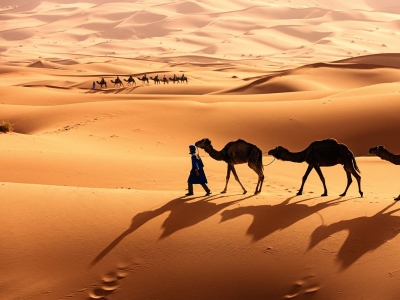
The Sahara desert has a variety of land features, but it is most famous for the sand dune fields that are often depicted in movies. The dunes can reach almost 600 feet (183 meters) high, and they cover about 25% of the entire desert, according to the Encyclopedia Britannica. Other topographical features include mountains, plateaus, sand- and gravel-covered plains, salt flats, basins and depressions. Emi Koussi, an extinct volcano in Chad, is the highest point in the Sahara, reaching 11,204 feet (3,415 m) above sea level,  and the Qattara Depression in northwestern Egypt is the Sahara’s deepest point, at 436 feet (133 m) below sea level.

Despite the harsh, arid conditions of the Sahara, many plant and animal species call the region home. Approximately 500 plant species, 70 mammalian species, 90 avian species, 100 reptilian species and numerous species of spiders, scorpions and other small arthropods live in the Sahara. The camel is one of the most iconic animals of the Sahara, though its ancestors originated in North America. Other mammal residents of the Sahara include gazelles, addaxes (a type of antelope), cheetahs, caracals, desert foxes and wild dogs. Many reptiles also thrive in the desert environment, including several species of snakes, lizards and even crocodiles in places where there is enough water. Several arthropod species also call the Sahara home, such as dung beetles, scarab beetles, “deathstalker” scorpions and many types of ants.

Today, the Sahara has a dry, inhospitable desert climate. The past 2,000 years or so, the climate of the Sahara has been fairly stable — and dry. The northeastern winds strip moisture from the air over the desert and drive hot winds toward the equator.

Credit : Live science

Picture Credit : Google 

What is special about Lake Tuz or Tuz Golu lake?

Lake Tuz or Tuz Golu is Turkey’s second largest lake. One of the largest hypersaline lakes in the world. Lake Tuz has a surface area of over 1,600 sq km. It is said that salt extracted from the lake is exported to more than 60 countries.

Lake Tuz is a saline lake (Tuz is Turkish for “salt”) located on the Central Anatolia plateau, about 150 kilometers (90 miles) south-southeast of Ankara. It is fed by groundwater that originates in the Northern Taurus Mountains and passes through Konya Plain and Obruk Plateau bubbles up into Lake Tuz via springs. Other sources of water include two major streams, and rain that primarily falls in the springtime. The lake has no outlet.

Water here has become increasingly scarce. The Mediterranean Basin, which includes Turkey, has already seen more frequent and intense droughts, according to a report by the Mediterranean Experts on Climate and Environmental Change. In addition, the Mediterranean Basin is considered a climate change hotspot, having warmed more since the pre-industrial period compared to the global average (1.5°C/2.7°F compared to 1.1°C/2.0°F).

After the year 2000, there was a distinct shift. Between 2001 and 2016, water spanned less than 20 percent of the lake in every August (except 2015) as droughts became more frequent and intense. In 2008 and 2016, the lake completely dried up. Aydin-Kandemir’s current research shows that more recently, extraordinary meteorological drought has devastated Lake Tuz since 2019. The patterns led the scientists to wonder why the lake had become more sensitive to drought after the year 2000. Before that time, Lake Tuz usually contained water even during periods of drought. But something changed.

Credit : Sci Tech Daily

Picture Credit : Google