Category Geography

WHAT IS THE RED FOREST?

With the ongoing Russian invasion of Ukraine, fears of a nuclear escalation and nuclear disasters persist. Ukraine, which is heavily dependent on its nuclear reactors for electricity production, has as many as 15 of them.

Radiation exposure of the people living in areas around them and those (the invading soldiers) coming there without precaution in the event of a disaster cannot be ruled out. And the least said about its impact on the environment is better.

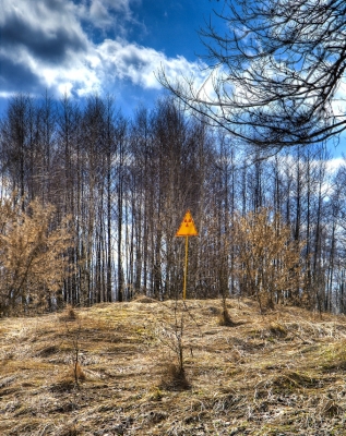
It was reported in March end that Russian soldiers who took control of the Chernobyl site drove heavy military vehicles without wearing any anti-radiation gear through a toxic zone called the “Red Forest”. But what is this Red Forest and why is it called so? Let’s find out.

Highly toxic zone

The Red Forest is the most radioactively contaminated outdoor environment. Spreading over 10 sq km around the Chernobyl Nuclear Power Plant within the Exclusion Zone near the town of Pripyat, it is a highly dangerous, toxic zone.

It got its name when pine trees covering several square kilometres in the area west of the Chernobyl plant turned a bright red and many of them died instantly as a result of radiation absorption from the world’s worst nuclear accident in 1986.

Still called the Red Forest, the site is off limits even for the nuclear plant workers. Apparently, the invading Russian troops suffered radiation sickness when they allegedly dug trenches in the highly toxic zone, kicking up clouds of radioactive dust.

The Chernobyl disaster

The Chernobyl Nuclear Power Plant accident in 1986 was the result of a flawed reactor design. On the night of April 26, 1986, a steam explosion and the resultant fire at the plant led to the uncontrolled release of radioactivity into the environment. It contaminated the soil, water, and atmosphere with radioactive material.

Due to the explosion, two plant workers died on the same night of the accident, and 28 more died within weeks as a result of acute radiation syndrome. Several lakhs of people were evacuated from the area. Did you know exposure to radioactive materials increases the risk of cancer, among other diseases, in people?

Picture Credit : Google 

WHAT NEW MINERAL FOUND IN DIAMOND FROM EARTH’S MANTLE?

Analysis of a ‘super-deep’ diamond from Orapa, Botswana, has revealed tiny crystals of a never-before-seen mineral trapped inside.

Davemaoite, named after geophysicist and deep-earth scientist, Ho-kwang (Dave) Mao, is the first example of a high-pressure calcium silicate perovskite (CaSiO3) found on Earth. Its crystalline structure forms only under high pressure and high temperatures in Earth’s mantle, the mainly solid layer of Earth between the outer core and the crust.

Normally, Davemaoite’s crystal structure would break apart if it was brought up to Earth’s surface because of the massive drop in pressure. But because it was trapped inside a rigid diamond, it was preserved on its long journey up to the Orapa mine, which probably took between 100 million to 1.5 billion years.

Most diamonds form 120 to 250 kms underground, but those of the super-deep variety are born in Earth’s lower mantle, which begins 660 kms below the surface.

Davemaoite makes up around 5-7% of the material in Earth’s lower mantle, and is important because it can host radioactive elements like uranium, thorium and potassium-40 that heat Earth as they decay.

Picture Credit : Google 

WHICH IS THE ASIA’S LARGEST SAL FOREST?

Saranda Forest is Asia’s largest Sal forest. Referred to as “the land of seven hundred hills”, the 82,000-hectare forest is located in West Singhbhum district in Jharkhand. It is famous for its majestic Sal trees, the principal dominating tree species, and is home to wild elephants and the endangered flying lizard. The forest stands atop one of the world’s largest single deposits of iron ore – over 2,000 million tonnes. Unchecked mining has destroyed  extensive swathes of Saranda, an estimated 14,410 have been lost to mining.

The magical sunrise and sunset of Kiriburu in the hills of Saranda is a spectacular sight. Saranda is often referred to as the land of seven hundred hills and is blessed with numerous waterfalls. This place is a delight for nature lovers and trekkers. Tourists can visit the twin cities of Kiriburu and Meghahatuburu, which are famous for their iron ore mines, governed by the Steel Authority of India Limited.

Some of the wild animals found here are Wild Elephants, Sambar, Chital, Beers, Bison, Tigers, and Leopards. Although the forest is stuffed with a huge number of Sal (Shorea robusta) trees, some of the other trees which are also found in large numbers are Mangoes, Jamun, Jackfruit, Guava, Mahua, Kusum, Tilai, Harin Hara (Armossa Rohitulea), Gular (Ficus Glomerata), and Asan. River Karo and Koina flow through the forest, contributing to a variety of flora and fauna. Due to the presence of a high amount of iron ore, the soil in the entire forest is red in color.

It is advisable to hire a guide while exploring the forest because there may be chances of getting lost as the forest is too dense and also there are a lot of wild animals. To explore some of the core parts of the forest, permission from the DFO (Divisional Forest Officer) is needed.

Credit :  Tripinfi

Picture Credit : Google 

WHY DO THE CONTINENTS MOVE?

The surface of Earth is broken into giant fragments called tectonic plates. The continents are situated on top of these tectonic plates, which carry them much like cargo on rafts. The plates move at rates of between 2 and 17 cm per year, and over millions of years this moves the continents over many thousands of kilometres.

The earth’s crust is broken into separate pieces called tectonic plates. The crust is the solid, rocky, outer shell of the planet. It is composed of two distinctly different types of material: the less-dense continental crust and the more-dense oceanic crust. Both types of crust rest atop solid, upper mantle material. The upper mantle, in turn, floats on a denser layer of lower mantle that is much like thick molten tar.

Each tectonic plate is free-floating and can move independently. Earthquakes and volcanoes are the direct result of the movement of tectonic plates at fault lines. The term fault is used to describe the boundary between tectonic plates. Most of the earthquakes and volcanoes around the Pacific ocean basin—a pattern known as the “ring of fire”—are due to the movement of tectonic plates in this region. Other observable results of short-term plate movement include the gradual widening of the Great Rift lakes in eastern Africa and the rising of the Himalayan Mountain range. The motion of plates can be described in four general patterns:

  • Collision: when two continental plates are shoved together
  • Subduction: when one plate plunges beneath another
  • Spreading: when two plates are pushed apart
  • Transform faulting: when two plates slide past each other

Credit: EXPLORING OUR FLUID EARTH

Picture Credit : Google

WHAT IS THE SAN ANDREAS FAULT IN CALIFORNIA, USA?

San Andreas Fault, major fracture of the Earth’s crust in extreme western North America. The fault trends northwestward for more than 800 miles (1,300 km) from the northern end of the Gulf of California through western California, U.S., passing seaward into the Pacific Ocean in the vicinity of San Francisco. Tectonic movement along the fault has been associated with occasional large earthquakes originating near the surface along its path, including a disastrous quake in San Francisco in 1906, a less serious event there in 1989, and a strong and destructive quake centred in the Los Angeles suburb of Northridge in 1994 that occurred along one of the San Andreas’s larger secondary faults.

According to the theory of plate tectonics, the San Andreas Fault represents the transform (strike-slip) boundary between two major plates of the Earth’s crust: the Northern Pacific to the south and west and the North American to the north and east. The Northern Pacific plate is sliding laterally past the North American plate in a northerly direction, and hence the San Andreas is classified as a strike-slip fault. The movement of the plates relative to each other has been about 1 cm (0.4 inch) per year over geologic time, though the annual rate of movement has been 4 to 6 cm (1.6 to 2.4 inches) per year since the early 20th century. Parts of the fault line moved as much as 6.4 metres (21 feet) during the 1906 earthquake.

Credit: Britannica

Picture Credit : Google

WHICH CONTINENTS COLLIDED TO FORM THE ALPS?

Continents collide, and the Alps begin to form

  • The North part of the African plate collides with the European plate and is thrust over the European plate. This is the start of the formation of the Alps which grows by 1000m per million years.
  • The Matterhorn is an interesting example of this collision:
  • The base of the Matterhorn contains rocks which were formed under the Tethys Sea. As the African plate moved into the Eurasian plate the denser oceanic crust was subducted under the lighter, continental crust.
  • The centre of the Matterhorn contains rocks from the Eurasian plate.
  • The top of the Matterhorn comprises of rocks from the African plate which was thrust up on top of the Eurasian plate when it collided together.

Credit: Alpen Wild

Picture Credit : Google