Category Geography

WHAT IS A BLOWHOLE?

Sometimes, the rocks along a coastline have a crevice or hole just above the low-tide mark. When the high tide rushes in, the crevice fills up with water, which tries to escape through this narrow hole. The build-up of pressure sprays out the water as an upward plume with a loud sound. This is a blowhole. Over time, a blowhole can create caves or even a pool of water near the coast.

When sea caves grow towards the land and upwards creating a vertical shaft that exposed on the surface, it results in a blowhole. Water often gushes out at the top part of the landform when waves move to the sea cave with significant force. The activities of the blowhole depend on the sea conditions as well as its geometry and that of the sea cave. A blowhole is characterized by an opening on the ground and a connection to an opening which interacts with the sea, mostly a cave.

Sea Caves are a common feature along the coasts and are formed through mechanical erosion of cliffs. Parts of weakness in the cliffs are weathered out by wave action thereby forming large cavities known as sea caves. These caves are regularly exposed to waves. Hydraulic pressure, built up by a succession of waves, eventually carves out a hole at the top of the cave to create an opening for water pressure to be expelled as a jet of spray. A blowhole can also be formed when lava flows make openings in the ground which extend towards the sea. The landform manifests as a crack or fissure once formed.

Credit: World Atlas

Picture Credit : Google 

WHAT IS A BAYMOUTH BAR?

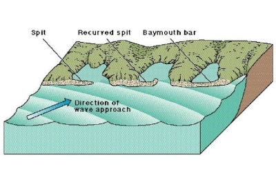
When the movement of waves deposits gravel and sand in a manner that prevents access to a bay, it builds up a baymouth bar. The existence of the bar creates a shallow lake known as a lagoon that is separated from the sea by a beach.

A baymouth bar is a depositional feature as a result of longshore drift. It is a spit that completely closes access to a bay, thus sealing it off from the main body of water. These bars usually consist of accumulated gravel and sand carried by the current of longshore drift and deposited at a less turbulent part of the current. Thus, they most commonly occur across artificial bay and river entrances due to the loss of kinetic energy in the current after wave refraction.

In most cases, a Sand Bypass System is built to prevent these bars forming across the entrance of man-made seaway’s, eliminating the danger posed to commercial and recreational boat owners passing through.

credit: en-academic.com

Picture Credit : Google 

WHICH IS THE LARGEST BLOWHOLE?

The Kiama Blowhole is a blowhole in the town of Kiama, New South Wales, Australia. The name ‘Kiama’ has long been translated as “where the sea makes a noise”. It is one of the town’s major tourist attractions. Under certain sea conditions, the blowhole can spray 50 litres of water up to 25 metres (82 ft) in the air, in quantities that thoroughly drench any bystanders. There is a second, less famous blowhole in Kiama, commonly referred to as the “Little Blowhole” by locals. It is much smaller than the other (called the “Big Blowhole”), but due to its narrow shape, it is more reliable than the Big Blowhole, and in the right conditions can be equally spectacular.

The blowhole attracts 900,000 tourists a year. Kiama Blowhole is just a few metres beyond the coastline. The “little blowhole” is located at the Little Blowhole Reserve, Tingira Crescent, Kiama, 2km south of the main blowhole.

The blowhole was formed from basalt lava flows approximately 260 million years ago and was first discovered by local Aboriginals who named it ‘Khanterinte’. The blowhole was first written about by George Bass on 6 December 1797. Bass had captained a crew of six and set out on an open whaleboat to explore the south coast of Australia. He noticed the blowhole after anchoring his boat in a sheltered bay.

Credit: Wikipedia

Picture Credit : Google 

WHAT IS A TOMBOLO?

Tombolo, one or more sandbars or spits that connect an island to the mainland. A single tombolo may connect a tied island to the mainland, as at Marblehead, Mass. A double tombolo encloses a lagoon that eventually fills with sediment; fine examples of these occur off the coast of Italy. The shallower waters that occur between an island and the mainland are the loci of such features because sandbars form there.

Adam’s Bridge, which connected Sri Lanka (Ceylon) with India across the 33-mile (53-kilometre) wide Palk Strait, was formerly the world’s largest tombolo. It was destroyed several thousand years ago by a slight change in mean sea level, and only a chain of sandbanks that seriously hinder navigation exists there today.

Credit: Britannica

Picture credit: Wikipedia

WHAT IS UNIQUE ABOUT TWELVE APOSTLES MARINE NATIONAL PARK, AUSTRALIA?

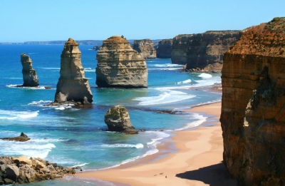
The Twelve Apostles Marine National Park is a protected marine national park located on the south-west coast of Victoria, Australia. The 7,500-hectare (19,000-acre) marine park is situated near Port Campbell and is named after the scenic The Twelve Apostles rock stacks, and contains the wreck of the clipper Loch Ard, wrecked on Mutton Bird Island in 1878. The marine park borders Port Campbell and Great Otway National Parks.

The limestone unit that forms The Twelve Apostles is referred to as the Port Campbell Limestone, which was deposited in the Mid-Late Miocene, around 15 to 5 million years ago.

The Twelve Apostles were formed by erosion. The harsh and extreme weather conditions from the Southern Ocean gradually erode the soft limestone to form caves in the cliffs, which then become arches that eventually collapse, leaving rock stacks up to 50 m (160 ft) high. The stacks are susceptible to further erosion from waves. In July 2005, a 50-metre-tall (160 ft) stack collapsed, leaving seven standing at the Twelve Apostles viewpoint. Due to wave action eroding the cliffs, existing headlands are expected to become new limestone stacks in the future.

The stacks were originally known as the Pinnacles, and the Sow and Pigs (or Sow and Piglets, with Mutton bird Island being the Sow and the smaller rock stacks being the Piglets), as well as the Twelve Apostles. The formation’s name was made official as the Twelve Apostles, despite only ever having had eight stacks.

Credit: Wikipedia

Picture Credit : Google 

WHAT IS A SEA STACK?

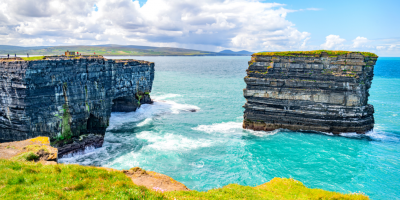
A sea stack is a vertical column of rock near a coast. This column is the remains of limestone cliffs that have been battered by the sea from both sides. At first, the waves carve out deep caves in the cliffs, which then gradually collapse, leaving behind the steep stack of rocks.

By definition, a sea stack is a naturally occurring pillar made up of stacked rocks, that projects up towards the sky. It is usually found surrounded by water, especially during high tide, isolated and separate from the mainland mass at a small distance away. During low tide, the water recedes far enough so that some sea stacks become accessible via the beach.

Standing at the foot of a sea stack, looking up at that magnificent, yet oddly placed rock formation, one is likely to wonder how exactly did it get there? While the possibility of a divine hand at work might seem alluring, the truth is actually a little more interesting. These grand structures of rocks are actually created by the erosive powers of waves and winds.

Sea stacks are formed from headlands. A headland is a coastal land-form that is quite high, and has a sheer drop that extends out into the sea or ocean. Parts of the headland that jut out into the water slowly get eroded over time by the mechanical energy of winds and waves. Essentially, the softer and weaker part of the rocks get eroded and break away, leaving behind the harder and stronger rock.

The formation process usually begins when water starts smashing against the portion of the headland rock that is jutting out, causing it to slowly erode. Coastal winds too assist in this process. Both, waves and winds chisel away at the rocks continuously for many years, until finally, a cave is formed.

Credit: Science Struck

Picture Credit : Google