Category Geography

WHAT ARE DRUMLINS?

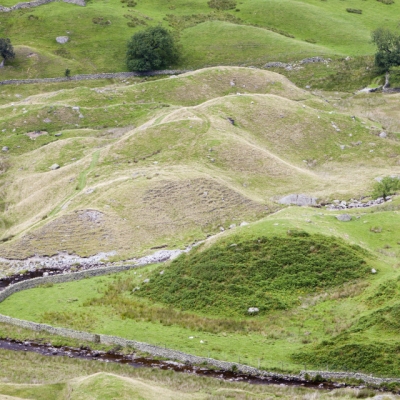
Rounded or mound-shaped hills created by glacial ice, drumlins are often found in clusters. They are largely made up of sediment deposited by a glacier and can vary greatly in size. The name derives from a Gaelic word droimin meaning ‘smallest ridges’.

Drumlin’s meaning is quite simple. Drumlins are elongated, oval-shaped or say teardrop-hills of rock, sand, and gravel. A drumlin is by and large made up of glacial drift, formed underneath an ice sheet or moving glacier and oriented in the direction of ice flow. There are no strict specifications with respect to the size of a drumlin but they tend to be up to a few kilometers up to 2 kilometers long and up to 50m in relief.

Drumlin glacier develops in the form of clusters apparently close to the terminus of glaciers. The mechanisms of formation are though disputed. They seemingly have significant interpretive value for rate and direction of glacial movement.

Drumlins are usually found in wide-ranging lowland regions, with their long axes approximately parallel to the path of glacial flow. Though they are observed in a multitude of shapes, the glacier side is always steep and high, while the lee side is tapered and smooth mildly in the direction of ice movement. Drumlins can hugely differ in size, with lengths from 1 to 2 km, heights from 50 to 100 feet, and widths from 400 to 600 m.

Credit: Vedantu

Picture Credit : Google 

WHAT ARE CIRQUES, ARÊTES AND HORNS?

Cirques are formed when a glacier wears away a mountainside leaving a rounded hollow with steep, almost vertical, walls. Such basins are usually found at the top of a glacial valley. Arêtes are knife-edged ridges between cirques that are created when glacial erosion occurs on both sides of a mountain. Horns are peaks created when three or more cirques are formed back to back.

Cirque amphitheatre-shaped basin with precipitous walls, at the head of a glacial valley. It generally results from erosion beneath the bergschrund of a glacier. A bergschrund is a large crevasse that lies a short distance from the exposed rock walls and separates the stationary from the moving ice; in early summer it opens, exposing the rock at its base to diurnal changes of temperature. Frost action then causes rapid disintegration of lower rock, which causes the upper rock to avalanche and produce an almost vertical head wall. Resulting rock material is embedded in the glacier and scours a concave floor, which may contain a small lake (tarn) if the glacier disappears. Expansion of neighbouring cirques produces sharp arêtes, cols, and horns. Because glaciers must originate above the snowline, a survey of the elevations of ancient cirques provides information on climatic change and on the former position of the snow line.

Arête in geology, a sharp-crested serrate ridge separating the heads of opposing valleys (cirques) that formerly were occupied by Alpine glaciers. It has steep sides formed by the collapse of unsupported rock, undercut by continual freezing and thawing. Two opposing glaciers meeting at an arête will carve a low, smooth gap, or col. An arête may culminate in a high triangular peak or horn (such as the Matterhorn) formed by three or more glaciers eroding toward each other.

A glacial horn is a feature created by glaciers and what exactly this term means is intricately linked with how it formed. A horn is a peak that forms from three arêtes. It is also known as a pyramidal peak.

An arête is the edge that forms in the land from cirque erosion, or when two cirque glaciers form up against each other, creating that sharp edge. When more than two arêtes meet, this is a horn.

Credit: Britannica

Picture Credit: Google

HOW DO WE KNOW THAT ICE ONCE COVERED AN AREA?

A study of rocks found in an area reveals much about its past. The debris and way that sediments have been changed and distorted gives evidence of ice covering that area. Also, land eroded by ice shows certain typical landforms such as glaciated valleys with cirques, arêtes and horns. All these indicate the presence of ice sometime in the past.

Sea ice may have covered the Earth’s surface all the way to the equator hundreds of millions of years ago, a new study finds, adding more evidence to the theory that a “snowball Earth” once existed.

The finding, detailed in the March 5 issue of the journal Science, also has implications for the survival and evolution of life on Earth through this bitter ice age.

Geologists found evidence that tropical areas were once covered by glaciers by examining ancient tropical rocks that are now found in remote northwestern Canada. These rocks have moved because the Earth’s surfaces, and the rocks on it, are in constant motion, pushed around by the roiling currents of the planet’s interior, a process called plate tectonics.

Credit: Live Science

Picture Credit : Google

WHAT IS AN ESKER?

Sometimes a stream cuts a channel under a slow-moving glacier, creating a long, winding ridge of sand and gravel that is called an esker. Before the glacier melted, the banks of these streams were defined by glacier ice. The deposited gravel now stands high above the surrounding land.

An esker is an attractive landform formed through fluvioglacial deposition. It is a winding ridge of low-lying stratified sand or gravel dominating the terrain and providing the vintage point and dry routes. An esker occurs in a glaciated area or a formerly glaciated region, especially in Europe and North America. The esker lies on valley floor within the ice margins marked by a moraine system suggesting that the eskers are formed beneath the glacier. The word esker is an Irish word meaning a ridge or an elevation which separates two plains. The term is also used to refer to ridges which are deposits of fluvioglacial material. Eskers vary in size and shapes with most of them being sinuous. The longest eskers are continuous and measure few kilometers while most of them are short and discontinuous.

Eskers are formed on washed sands and gravel. Most eskers are formed within ice-walled tunnel by streams which flow under and within glaciers. When the ice wall melts away, water deposits remain as winding ridges. Eskers can also be formed above the glacier through the accumulation of sediments in supraglacial channels. Eskers are formed at the terminal zones of glaciers where the ice is flowing relatively slowly. The melt water collects and flows through a network of tunnels. This water carries highly charged with debris which is composed of coarse-grained gravel which are stratified and sorted. The shape and size of the subglacial tunnel are determined by the flow and melting of the ice. The form of the tunnel then determines the shape and structure of an esker.

Credit: World Atlas

Picture Credit : Google

WHY DO SOME SURFACES GET WET?

Find out from this experiment

If water is poured on a glass slab, the glass becomes wet; but if mercury is poured on the same glass surface it does not become wet. Why?

Whether a surface gets wet or not depends on

 1. The force of attraction between the molecules of the liquid and the molecules of the surface with which it is in contact, and

2. The cohesive force between the molecules of the liquid.

In the case of mercury, its molecules hold on tightly to each other. The molecules of the glass surface cannot pull them away. So the surface does not get wet.

In the case of water, the adhesive force is greater than the cohesive force between the water molecules. So the water clings to the glass surface, wetting it.

Picture Credit : Google 

What is a spit?

A spit is a narrow, extended piece of land that develops where a coastline sharply turns in towards the landmass. Attached to the coast at one end, the spit seems to grow out of it, as the movement of waves and tides deposits sand and pebbles at the angle of the landmass. The other end extends out into the sea, growing longer over time as more debris accumulates along it.

Spit is a landform in geography that is created from the deposition of the sand by the tide movements. One end of the spit remains attached to the mainland while the other end is open out in the water. It is narrow and elongated. Also known as sandspit, this type of landform is found off the coasts or the lake shores.

Spits are usually formed when re-entrance takes place by the longshore drift process from longshore currents. When waves at an oblique angle meet the beach, drift occurs. There is a deposit of sediment in a narrow strip in zigzag pattern moving down the beach. The same waves also cause longshore currents that complement the formation of the spit.

At the re-entrance, the longshore current spreads out or dissipates and not being able to carry the full load, drops much of the sediment which is called deposition. The longshore or littoral drift continues to transport sediment with the help of this submerged bar of deposit into the open waters alongside the beach in the direction the waves are breaking

This process forms an above-water spit. The formation of spit will continue out into the sea until the water pressure obstructs in the deposition of sand. As it grows, it becomes stable and often fertile; vegetation starts to grow and supports habitation.

Credit: Earth Eclipse

Picture Credit : Google