Category Geography

WHAT IS PERMAFROST AND WHY IS IT IMPORTANT?

Permafrost is permanently frozen ground comprising soil, rocks, and sand, and often spans the Arctic regions. Found both on land and below the ocean floor, it covers vast expanses, and is a habitat for several animals and plants. Melting permafrost is a concern because it releases vast amounts of trapped greenhouse gases into the atmosphere.

What is Permafrost Made Of?

Permafrost is made of a combination of soil, rocks and sand that are held together by ice. The soil and ice in permafrost stay frozen all year long.

Near the surface, permafrost soils also contain large quantities of organic carbon—a material leftover from dead plants that couldn’t decompose, or rot away, due to the cold. Lower permafrost layers contain soils made mostly of minerals.

A layer of soil on top of permafrost does not stay frozen all year. This layer, called the active layer, thaws during the warm summer months and freezes again in the fall. In colder regions, the ground rarely thaws—even in the summer. There, the active layer is very thin—only 4 to 6 inches (10 to 15 centimeters). In warmer permafrost regions, the active layer can be several meters thick.

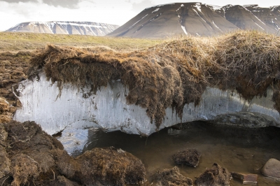
How Does Climate Change Affect Permafrost?

As Earth’s climate warms, the permafrost is thawing. That means the ice inside the permafrost melts, leaving behind water and soil.

Thawing permafrost can have dramatic impacts on our planet and the things living on it. For example:

  1. Many northern villages are built on permafrost. When permafrost is frozen, it’s harder than concrete. However, thawing permafrost can destroy houses, roads and other infrastructure.
  2. When permafrost is frozen, plant material in the soil—called organic carbon—can’t decompose, or rot away. As permafrost thaws, microbes begin decomposing this material. This process releases greenhouse gases like carbon dioxide and methane to the atmosphere.
  3. When permafrost thaws, so do ancient bacteria and viruses in the ice and soil. These newly-unfrozen microbes could make humans and animals very sick. Scientists have discovered microbes more than 400,000 years old in thawed permafrost.
  4. Because of these dangers, scientists are closely monitoring Earth’s permafrost. Scientists use satellite observations from space to look at large regions of permafrost that would be difficult to study from the ground.

Credit : Climate kids

Picture Credit : Google 

WHAT IS A MONSOON SEASON?

A monsoon is a seasonal wind pattern that lasts for several months and results in heavy rainfall during the summer and dry spells in the winter. It is responsible for the wet and dry seasons throughout much of the tropics. Typically Indian monsoon lasts from June-September, with large areas of western and central India receiving more than 90% of their total annual precipitation during the period. The word comes from the Arabic ‘mausin’ which means season and was first used in the English language during the British occupation of India.

What causes a monsoon?

A monsoon (from the Arabic mawsim, which means “season”) arises due to a difference in temperatures between a land mass and the adjacent ocean, according to the National Weather Service. The sun warms the land and ocean differently, according to Southwest Climate Change, causing the winds to play “tug of war” eventually switching directions bringing the cooler, moister air from over the ocean. The winds reverse again at the end of the monsoon season.

Wet versus dry

A wet monsoon typically occurs during the summer months (about April through September) bringing heavy rains, according to National Geographic. On average, approximately 75 percent of India’s annual rainfall and about 50 percent of the North American monsoon region (according to a 2004 NOAA study) comes during the summer monsoon season. The wet monsoon begins when winds bringing cooler, more humid air from above the oceans to the land, as described above.

A dry monsoon typically occurs between October and April. Instead of coming from the oceans, the winds tend to come from drier, warmer climates such as from Mongolia and northwestern China down into India, according to National Geographic. Dry monsoons tend to be less powerful than their summer counterparts. Edward Guinan, an astronomy and meteorology professor at Villanova University, states that the winter monsoon occurs when “the land cools off faster than the water and a high pressure develops over the land, blocking any ocean air from penetrating.” This leads to a dry period.

The winds and rains

The monsoon season varies in strength each year bringing periods of lighter rains and heavier rains as well as slower wind speeds and higher wind speeds. The Indian Institute of Tropical Meteorology has compiled data showing yearly rainfalls across India for the last 145 years.

According to the data, the intensity of a monsoon varies over an average of period of 30 – 40 years. In each period, the amount of rain received is higher than average resulting in many floods or lower than average resulting in droughts. The long-term data suggest that the monsoon trends may turn from being in a low rain period that began in approximately 1970 to a higher rain period. Current records for 2016 indicate that total rainfall between June 1 and September 30 is 97.3 percent of the seasonal normal.

The most rain during a monsoon season, according to Guinan, was in Cherrapunji, in the state of Meghalaya in India between 1860 and 1861 when the region received 26,470 millimeters (1,047 inches) of rain. The area with the highest average annual total (which was observed over a ten year period) is Mawsynram, also in Meghalaya, with an average of 11,872 millimeters (467.4 inches) of rain.

The average wind speeds in Meghalaya during peak summer monsoon season average 4 kilometers per second and typically vary between 1 and 7 kilometers per hour, according to Meteoblue. During the winter months, wind speeds typically vary between 2 and 8 kilometers per hour with an average of 4 – 5 kilometers per hour.

Credit : Live science 

Picture Credit : Google 

WHAT IS DEFORESTATION?


The intentional clearing of forested land is called deforestation. Throughout history and into current times, forests have been cleared in order to convert the forest land to farms, ranches, or urban uses. While deforestation has greatly changed the world’s landscapes, the greatest concentration of deforestation today is taking place in tropical rainforests. Deforestation not only results in more carbon dioxide being released into the atmosphere, but also threatens the world’s biodiversity as these forests are usually home to many species of plants and animals.

The Food and Agriculture Organization of the United Nations defines deforestation as the conversion of forest to other land uses (regardless of whether it is human-induced). “Deforestation” and “forest area net change” are not the same: the latter is the sum of all forest losses (deforestation) and all forest gains (forest expansion) in a given period. Net change, therefore, can be positive or negative, depending on whether gains exceed losses, or vice versa.

The removal of trees without sufficient reforestation has resulted in habitat damage, biodiversity loss, and aridity. Deforestation causes extinction, changes to climatic conditions, desertification, and displacement of populations, as observed by current conditions and in the past through the fossil record. Deforestation also reduces biosequestration of atmospheric carbon dioxide, increasing negative feedback cycles contributing to global warming. Global warming also puts increased pressure on communities who seek food security by clearing forests for agricultural use and reducing arable land more generally. Deforested regions typically incur significant other environmental effects such as adverse soil erosion and degradation into wasteland.

The resilience of human food systems and their capacity to adapt to future change is linked to biodiversity – including dryland-adapted shrub and tree species that help combat desertification, forest-dwelling insects, bats and bird species that pollinate crops, trees with extensive root systems in mountain ecosystems that prevent soil erosion, and mangrove species that provide resilience against flooding in coastal areas.] With climate change exacerbating the risks to food systems, the role of forests in capturing and storing carbon and mitigating climate change is important for the agricultural sector.

Credit : Wikipedia

Picture Credit : Google 

WHAT IS SPECIAL ABOUT THE GEOGRAPHIC SOUTH POLE?

The geographic South Pole in Antarctica is the only place on earth where you can time travel! All lines of longitude converge at this exact point, so you are literally standing in all 24 time zones. You can step from today into yesterday and back into tomorrow! Since Antarctica is largely uninhabited, the continent is not officially divided into time zones. Research stations use the time zone of the country that operates them, while others observe the local time of countries nearby officially divided into time zones. Research stations use the time zone of the country that operates them, while others observe the local time of countries nearby.

What is a time zone?

A time zone can be described as a region of the Earth that observes a standard time for several purposes, including commercial, legal, and social. Time zones often follow the boundaries of a country and its subdivisions since it is convenient for places in close proximity to observe the same time. Time zones on land are usually offset from Coordinated Universal Time (UTC). The Earth’s rotation means that time zones are determined by the lines of longitude that connect the North and South Poles, and divide the globe into different time zones. A country or region may have multiple time zones. For example, the United States is spread across six time zones. However, since all lines of longitude converge at the poles, it means that the poles are technically located within all time zones simultaneously.

Time at the geographic poles.

In most parts of the globe, lines of longitude determine the local time, such that the specific time is synchronized to the position of the Sun in the sky. However, this does not apply at the North and South Poles, where the rising and setting of the Sun occurs only once a year. At the North Pole, the sun is continuously above the horizon in the summer and below the horizon during winter. The Sun rises during the March equinox and reaches sunset around the September equinox. The South Pole does not receive any sunlight from March until September, while the Sun is continuously above the horizon from September until March, meaning that the pole experiences one of the coldest climates in the world.

How is time determined at the geographical poles?

While there are no permanent human settlements at the poles and no specific time zone has been assigned to either pole, explorers and polar expeditions choose to follow any time zone deemed convenient. Therefore, a group of explorers may choose to observe the same time zone as their country of origin or may opt to use Greenwich Mean Time. For example, a group working at the McMurdo Station in the South Pole followed the local time in New Zealand local time (UTC+12 or 13).

Credit : World atlas 

Picture Credit : Google 

WHY DEAD SEA CALLED DEAD SEA?

At the very lowest point on earth lies a natural wonder replete with a unique ecosystem, breathtaking desert views, and mineral treasures that have been attracting visitors for thousands of years: The Dead Sea. Located in the desert in southern Israel, it is also the world’s deepest hypersaline lake. Although the high salinity of the water makes it almost impossible to dive, in this article we will delve deep into its geological origins, geography and history, become familiar with the biology and chemistry of this unique environment and discover everything there is to do and where to stay in the area surrounding this natural gem.

The Dead Sea is a salt lake located in the Judean desert of southern Israel, bordered by Jordan to the East. With its origin dating back to some four million years ago, it is one of earth’s saltiest bodies of water and is the lowest point on earth. Its arid desert climate features year-round sunny skies, relatively high temperatures, with little precipitation.

The Dead Sea is located at the lowest point on earth, which is thought to be the result of volcanic processes leading to a continuous dropping of land. It is one of the four saltiest bodies of water in the world. These special conditions are an outcome of its extreme geomorphological structure alongside a harsh desert climate. These create constant dramatic changes that form a landscape that is different from any other in the world. Also, the unique mineral content of the air, land, and water in the area is globally renowned for its therapeutic qualities, as is evident in that it has been a health resort for thousands of years.

There are contending theories about the Dead Sea formation. About 3.7 million years ago, the area now known as the Jordan River Valley was repeatedly flooded by water from the Mediterranean Sea. The waters created a lagoon called the Sedom Lagoon, which connected to the sea through what is currently called the Jezreel Valley. Later on, about 2 million years ago, the land between this lagoon and the Mediterranean Sea rose to such an extent, that the sea could no longer flood the area, leading to the creation of a landlocked lake. Shifts in tectonic plates led to the rising and dropping of the floor of the valley, and the harsh desert climate led to gradual evaporation and shrinking of the lake, until finally, about 70,000 years ago, what remained was the Dead Sea with its low elevation.

Until the end of the 1960s, the Jordan River was the only major water source flowing into the Dead Sea, although there are small perennial springs under and around the lake, forming pools and quicksand pits along its edges. Today, after the diversion of the waters from the Sea of Galilee, the only incoming source of water is from sulfur springs and waste water, along with rare drizzles and flash floods.

Credit : Deadsea.com

Picture Credit : Google 

WHAT IS SPECIAL ABOUT EL VIZCAINO BIOSPHERE RESERVE IN MEXICO?

Dominated by a variety of landscapes, the El Vizcaino Biosphere Reserve in Mexico is an important region for many migratory marine and bird species

Rich in biodiversity

Mexico’s largest protected area, the El Vizcaino Biosphere Reserve spreads over more than 250 sq.km. It covers a large region between Baja California and the Gulf of California (also known as the Sea of Cortes), making it rich in both terrestrial and marine life. Dominated by scrublands, pine forests, coastal dunes, mangroves, and lagoons, the Reserve is fertile too. It supports more than 400 floral species and 300 vertebrates, in addition to several species of fish. It is an important region for many migratory marine and bird species. The Whale Sanctuary of El Vizcaino, which falls within the boundaries. of the Reserve, was declared a UNESCO World Heritage Site in 1993. It is an important reproduction and wintering site for not just the grey whale but also other species such as seals and sea lions.

The Reserve faces threats in the form of agriculture, illegal fishing, and hunting, in addition to infrastructure development projects. It is believed that all these could have a major impact on the biodiversity of the region..

Wildlife

While the grey whale is the most significant creature of the region, there are several species of birds and mammals found here. Marine mammals seen here are turtles. seals, sea lions, and dolphins. Among the birds spotted are ospreys, pelicans, egrets, cormorants, gulls, terns, plovers, eagles, and falcons. Migrant species that arrive here include the Pacific black brant and northern pintails. In addition to mammals such as pronghorn, deer, bobcats, coyotes, sheep, and squirrels, there are also many types of reptiles and amphibians, including lizards and snakes.

Picture Credit : Google