Category Geography

WHAT IS AN ESKER?

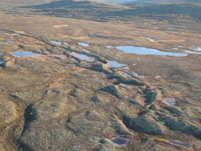
Sometimes a stream cuts a channel under a slow-moving glacier, creating a long, winding ridge of sand and gravel that is called an esker. Before the glacier melted, the banks of these streams were defined by glacier ice. The deposited gravel now stands high above the surrounding land.

An esker is an attractive landform formed through fluvioglacial deposition. It is a winding ridge of low-lying stratified sand or gravel dominating the terrain and providing the vintage point and dry routes. An esker occurs in a glaciated area or a formerly glaciated region, especially in Europe and North America. The esker lies on valley floor within the ice margins marked by a moraine system suggesting that the eskers are formed beneath the glacier. The word esker is an Irish word meaning a ridge or an elevation which separates two plains. The term is also used to refer to ridges which are deposits of fluvioglacial material. Eskers vary in size and shapes with most of them being sinuous. The longest eskers are continuous and measure few kilometers while most of them are short and discontinuous.

Eskers are formed on washed sands and gravel. Most eskers are formed within ice-walled tunnel by streams which flow under and within glaciers. When the ice wall melts away, water deposits remain as winding ridges. Eskers can also be formed above the glacier through the accumulation of sediments in supraglacial channels. Eskers are formed at the terminal zones of glaciers where the ice is flowing relatively slowly. The melt water collects and flows through a network of tunnels. This water carries highly charged with debris which is composed of coarse-grained gravel which are stratified and sorted. The shape and size of the subglacial tunnel are determined by the flow and melting of the ice. The form of the tunnel then determines the shape and structure of an esker.

Credit: World Atlas

Picture Credit: Google

Can reforestation alone save the Earth?

Trees are huge carbon sinks. They saok up the carbon. Planting trees will help mitigate the climate change and cool the planet to some extent. But that has to be combined with a dedicated effort to reduce carbon emission. Reforestation combined with the reduction of greenhouse gases, especially carbon dioxide (CO2), is the need of the hour. It is these gases that warm the earth, leading to climate change which we have been witnessing in many forms such as the melting of ice sheets, rising of sea levels, wildfires, floods, droughts and other natural calamities. So the carbon emissions need to be reduced by nations, on an industrial scale as well as individual level.

Picture Credit : Google 

HOW DO WE KNOW THAT ICE ONCE COVERED AN AREA?

A study of rocks found in an area reveals much about its past. The debris and way that sediments have been changed and distorted gives evidence of ice covering that area. Also, land eroded by ice shows certain typical landforms such as glaciated valleys with cirques, arêtes and horns. All these indicate the presence of ice sometime in the past.

Sea ice may have covered the Earth’s surface all the way to the equator hundreds of millions of years ago, a new study finds, adding more evidence to the theory that a “snowball Earth” once existed.

The finding, detailed in the March 5 issue of the journal Science, also has implications for the survival and evolution of life on Earth through this bitter ice age.

Geologists found evidence that tropical areas were once covered by glaciers by examining ancient tropical rocks that are now found in remote northwestern Canada. These rocks have moved because the Earth’s surfaces, and the rocks on it, are in constant motion, pushed around by the roiling currents of the planet’s interior, a process called plate tectonics.

Credit: Live Science

Picture Credit: Google

WHAT IS A BLOWHOLE?

Sometimes, the rocks along a coastline have a crevice or hole just above the low-tide mark. When the high tide rushes in, the crevice fills up with water, which tries to escape through this narrow hole. The build-up of pressure sprays out the water as an upward plume with a loud sound. This is a blowhole. Over time, a blowhole can create caves or even a pool of water near the coast.

When sea caves grow towards the land and upwards creating a vertical shaft that exposed on the surface, it results in a blowhole. Water often gushes out at the top part of the landform when waves move to the sea cave with significant force. The activities of the blowhole depend on the sea conditions as well as its geometry and that of the sea cave. A blowhole is characterized by an opening on the ground and a connection to an opening which interacts with the sea, mostly a cave.

Sea Caves are a common feature along the coasts and are formed through mechanical erosion of cliffs. Parts of weakness in the cliffs are weathered out by wave action thereby forming large cavities known as sea caves. These caves are regularly exposed to waves. Hydraulic pressure, built up by a succession of waves, eventually carves out a hole at the top of the cave to create an opening for water pressure to be expelled as a jet of spray. A blowhole can also be formed when lava flows make openings in the ground which extend towards the sea. The landform manifests as a crack or fissure once formed.

Credit: World Atlas

Picture Credit: Google

What is a spit?

A spit is a narrow, extended piece of land that develops where a coastline sharply turns in towards the landmass. Attached to the coast at one end, the spit seems to grow out of it, as the movement of waves and tides deposits sand and pebbles at the angle of the landmass. The other end extends out into the sea, growing longer over time as more debris accumulates along it.

Spit is a landform in geography that is created from the deposition of the sand by the tide movements. One end of the spit remains attached to the mainland while the other end is open out in the water. It is narrow and elongated. Also known as sandspit, this type of landform is found off the coasts or the lake shores.

Spits are usually formed when re-entrance takes place by the longshore drift process from longshore currents. When waves at an oblique angle meet the beach, drift occurs. There is a deposit of sediment in a narrow strip in zigzag pattern moving down the beach. The same waves also cause longshore currents that complement the formation of the spit.

At the re-entrance, the longshore current spreads out or dissipates and not being able to carry the full load, drops much of the sediment which is called deposition. The longshore or littoral drift continues to transport sediment with the help of this submerged bar of deposit into the open waters alongside the beach in the direction the waves are breaking

This process forms an above-water spit. The formation of spit will continue out into the sea until the water pressure obstructs in the deposition of sand. As it grows, it becomes stable and often fertile; vegetation starts to grow and supports habitation.

Credit: Earth Eclipse

Picture Credit: Google

WHICH PLACE HOLDS THE RECORD FOR RECEIVING THE HIGHEST RAINFALL IN INDIA?

Mawsynram is a town in the East Khasi Hills district of Meghalaya state in Northeastern India, 60.9 kilometres from Shillong, the state capital. Mawsynram receives the highest rainfall in India. It is reportedly the wettest place on Earth, with an average annual rainfall of 11,872 millimetres (467.4 in), According to the Guinness Book of World Records, Mawsynram received 26,000 millimetres (1,000 in) of rainfall in 1985. Mawsynram received 745.2 mm of rainfall on 19 August 2015, probably the highest rainfall received by the town in recent times.] On June 17th 2022, Mawsynram set a new record by receiving 1003.6 mm in a span of 24 hours which has now become its highest single day record for the month of June and for its all time single day record beating its former record of 944.7 mm on June 7th 1966.

Mawsynram is located at 25° 18? N, 91° 35? E, at an altitude of about 1,400 metres (4,600 ft), 15 km west of Cherrapunji, in the Khasi Hills in the state of Meghalaya (India). Under the Köppen climate classification, Mawsynram features a subtropical highland climate (Cwb) with an extraordinarily showery, rainy and long monsoonal season and a short dry season. Based on the data of a recent few decades, it appears to be the wettest place in the world, or the place with the highest average annual rainfall. Mawsynram receives over 10,000 millimeters of rain in an average year, and the vast majority of the rain it gets falls during the monsoon months. A comparison of rainfalls for Cherrapunji and Mawsynram for some years is given in Table 1. Mawsynram receives the highest rainfall in India. Although it is reportedly the wettest place on Earth, with an average annual rainfall of 11,872 millimetres (467.4 in), this claim is disputed by Lloró, Colombia, which reported an average yearly rainfall of 12,717 millimetres (500.7 in) between 1952 and 1989 and López de Micay, also in Colombia, which reported 12,892 mm (507.6 in) per year between 1960 and 2012. According to the records observed by the Indian Meterological Department, it was seen that while its neighbour, Cherrapunji is having a significant decreasing trend in rainfall, Mawsynram on the other hand is experiencing a slight increase in its rainfall pattern which put its average annual rainfall from 1950 to 2000 at 12393 mm and from 2000 to 2020 at 12120 mm. The precipitation table below shows the average monthly record from 1950-2000.

Credit : Wikipedia 

Picture Credit : Google