Category Geography

DOES ANTARCTICA HOLD MOST OF THE WORLD’S FRESH WATER?

The Antarctic ice cap contains about 91% of all the ice in the world and about 86% of all freshwater that occurs in the form of ice. But despite all this freshwater, Antarctica is considered one of the most arid places on Earth.

Antarctica is the highest, coldest, driest, and windiest of the world’s continents. It is also “tallest” in terms of average height above sea level. Nearly 99% of this land mass is covered with an ice cap with an average altitude of around 2 200 metres above sea level. The area of this vast continent – some 14 million square kilometres – doubles in the winter, when sea ice can stretch as much as 1000 km outwards from the coastline.

Most of the continent of Antarctica lies south of 70°S, although the Antarctic Peninsula stretches northward as far as 60°S. The continent is surrounded by the Southern Ocean, a circumpolar sea that isolates Antarctica from the other continents.

Most of Antarctica is covered with ice, but in many places mountain peaks (nunataks) stick up out of the ice. The Vinson Massif in West Antarctica, with an elevation of 5 140 m, is the highest peak in Antarctica. In addition to the nunataks, there are large ice-free regions called oases where the ice has retreated and where melting outstrips accumulation of new snow. Other areas, known as dry valleys, are free of ice because essentially no precipitation falls there.

Picture credit: Google

WHAT IS A GLACIAL ERRATIC?

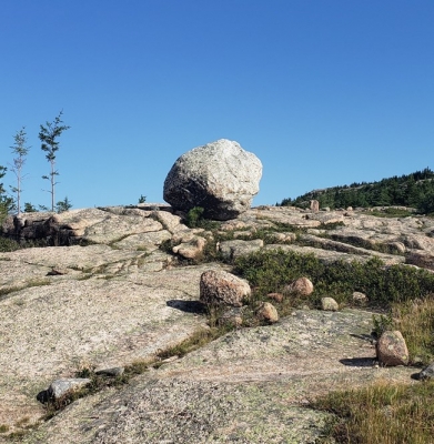
A rock resting on rocks from which it differs drastically is a glacial erratic. It would have been transported to a location many kilometres away from its place of origin by glacial erosion. An erratic can vary in size from a small rock to a very big boulder. Studying such rocks helps scientists define the path of glacial movement.

A glacial erratic is glacially deposited rock differing from the type of rock native to the area in which it rests. Erratics, which take their name from the Latin word errare (to wander), are carried by glacial ice, often over distances of hundreds of kilometres. Erratics can range in size from pebbles to large boulders such as Big Rock (16,500 tonnes or 18,200 short tons) in Alberta.

Geologists identify erratics by studying the rocks surrounding the position of the erratic and the composition of the erratic itself. Erratics are significant because:

  • They can be transported by glaciers, and they are thereby one of a series of indicators which mark the path of prehistoric glacier movement. Their lithographic origin can be traced to the parent bedrock, allowing for confirmation of the ice flow route.
  • They can be transported by ice rafting. This allows quantification of the extent of glacial flooding resulting from ice dam failure which release the waters stored in proglacial lakes such as Lake Missoula. Erratics released by ice-rafts that were stranded and subsequently melted, dropping their load, allow characterization of the high-water marks for transient floods in areas like temporary Lake Lewis.
  • Erratics dropped by icebergs melting in the ocean can be used to track Antarctic and Arctic-region glacial movements for periods prior to record retention. Also known as dropstones, these can be correlated with ocean temperatures and levels to better understand and calibrate models of the global climate.

Credit: Wikipedia

Picture Credit: Google

WHAT IS A KETTLE?

kettle, also called Kettle Hole, in geology, depression in a glacial outwash drift made by the melting of a detached mass of glacial ice that became wholly or partly buried. The occurrence of these stranded ice masses is thought to be the result of gradual accumulation of outwash atop the irregular glacier terminus. Kettles may range in size from 5 m (15 feet) to 13 km (8 miles) in diameter and up to 45 m in depth. When filled with water they are called kettle lakes. Most kettles are circular in shape because melting blocks of ice tend to become rounded; distorted or branching depressions may result from extremely irregular ice masses.

Two types of kettles are recognized: a depression formed from a partially buried ice mass by the sliding of unsupported sediment into the space left by the ice and a depression formed from a completely buried ice mass by the collapse of overlying sediment. By either process, small kettles may be formed from ice blocks that were not left as the glacier retreated but rather were later floated into place by shallow melt water streams. Kettles may occur singly or in groups; when large numbers are found together, the terrain appears as mounds and basins and is called kettle and kame topography.

Credit: Britannica

Picture Credit: Google

WHAT ARE MORAINE RIDGES?

The variety of loose rocks and sediments dumped over landscape give evidence about the type of glacier and glaciation that took place in the area. A moraine ridge is the landform created by the debris left by a glacier after it has moved away. Moraine ridges are given names according to the size of debris and how they were formed. Examples are: lateral moraine, recessional moraine, medial moraine and ground moraine.

A moraine is material left behind by a moving glacier. This material is usually soil and rock. Just as rivers carry along all sorts of debris and silt that eventually builds up to form deltas, glaciers transport all sorts of dirt and boulders that build up to form moraines.

Moraines only show up in places that have, or used to have, glaciers. Glaciers are extremely large, moving rivers of ice. Glaciers shape the landscape in a process called glaciation. Glaciation can affect the land, rocks, and water in an area for thousands of years. That is why moraines are often very old.


Lateral Moraine

A lateral moraine forms along the sides of a glacier. As the glacier scrapes along, it tears off rock and soil from both sides of its path. This material is deposited as lateral moraine at the top of the glacier’s edges. Lateral moraines are usually found in matching ridges on either side of the glacier. The glacier pushes material up the sides of the valley at about the same time, so lateral moraines usually have similar heights.

Medial Moraine

A medial moraine is found on top of and inside an existing glacier. Medial moraines are formed when two glaciers meet. Two lateral moraines from the different glaciers are pushed together. This material forms one line of rocks and dirt in the middle of the new, bigger glacier.

Supraglacial Moraine

A supraglacial moraine is material on the surface of a glacier. Lateral and medial moraines can be supraglacial moraines. Supraglacial moraines are made up of rocks and earth that have fallen on the glacier from the surrounding landscape. Dust and dirt left by wind and rain become part of supraglacial moraines. Sometimes the supraglacial moraine is so heavy; it blocks the view of the ice river underneath.

Ground Moraine

Ground moraines often show up as rolling, strangely shaped land covered in grass or other vegetation. They don’t have the sharp ridges of other moraines. A ground moraine is made of sediment that slowly builds up directly underneath a glacier by tiny streams, or as the result of a glacier meeting hills and valleys in the natural landscape. When a glacier melts, the ground moraine underneath is exposed.

Terminal Moraine

A terminal moraine is also sometimes called an end moraine. It forms at the very end of a glacier, telling scientists today important information about the glacier and how it moved. At a terminal moraine, all the debris that was scooped up and pushed to the front of the glacier is deposited as a large clump of rocks, soil, and sediment.

Credit: National Geographic

Picture Credit: Google

WHAT ARE CIRQUES, ARÊTES AND HORNS?

Cirques are formed when a glacier wears away a mountainside leaving a rounded hollow with steep, almost vertical, walls. Such basins are usually found at the top of a glacial valley. Arêtes are knife-edged ridges between cirques that are created when glacial erosion occurs on both sides of a mountain. Horns are peaks created when three or more cirques are formed back to back.

Cirque amphitheatre-shaped basin with precipitous walls, at the head of a glacial valley. It generally results from erosion beneath the bergschrund of a glacier. A bergschrund is a large crevasse that lies a short distance from the exposed rock walls and separates the stationary from the moving ice; in early summer it opens, exposing the rock at its base to diurnal changes of temperature. Frost action then causes rapid disintegration of lower rock, which causes the upper rock to avalanche and produce an almost vertical head wall. Resulting rock material is embedded in the glacier and scours a concave floor, which may contain a small lake (tarn) if the glacier disappears. Expansion of neighbouring cirques produces sharp arêtes, cols, and horns. Because glaciers must originate above the snowline, a survey of the elevations of ancient cirques provides information on climatic change and on the former position of the snow line.

Arête in geology, a sharp-crested serrate ridge separating the heads of opposing valleys (cirques) that formerly were occupied by Alpine glaciers. It has steep sides formed by the collapse of unsupported rock, undercut by continual freezing and thawing. Two opposing glaciers meeting at an arête will carve a low, smooth gap, or col. An arête may culminate in a high triangular peak or horn (such as the Matterhorn) formed by three or more glaciers eroding toward each other.

A glacial horn is a feature created by glaciers and what exactly this term means is intricately linked with how it formed. A horn is a peak that forms from three arêtes. It is also known as a pyramidal peak.

An arête is the edge that forms in the land from cirque erosion, or when two cirque glaciers form up against each other, creating that sharp edge. When more than two arêtes meet, this is a horn.

Credit: Britannica

Picture Credit: Google 

WHAT ARE DRUMLINS?

Rounded or mound-shaped hills created by glacial ice, drumlins are often found in clusters. They are largely made up of sediment deposited by a glacier and can vary greatly in size. The name derives from a Gaelic word droimin meaning ‘smallest ridges’.

Drumlin’s meaning is quite simple. Drumlins are elongated, oval-shaped or say teardrop-hills of rock, sand, and gravel. A drumlin is by and large made up of glacial drift, formed underneath an ice sheet or moving glacier and oriented in the direction of ice flow. There are no strict specifications with respect to the size of a drumlin but they tend to be up to a few kilometers up to 2 kilometers long and up to 50m in relief.

Drumlin glacier develops in the form of clusters apparently close to the terminus of glaciers. The mechanisms of formation are though disputed. They seemingly have significant interpretive value for rate and direction of glacial movement.

Drumlins are usually found in wide-ranging lowland regions, with their long axes approximately parallel to the path of glacial flow. Though they are observed in a multitude of shapes, the glacier side is always steep and high, while the lee side is tapered and smooth mildly in the direction of ice movement. Drumlins can hugely differ in size, with lengths from 1 to 2 km, heights from 50 to 100 feet, and widths from 400 to 600 m.

Credit: Vedantu

Picture Credit: Google