Category The World Around us

Which is the largest desert in Africa?

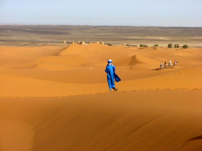
The Sahara is one of the harshest environments on Earth, covering 3.6 million square miles (9.4 million square kilometers), nearly a third of the African continent, about the size of the United States (including Alaska and Hawaii). The name of the desert comes from the Arabic word ?a?r??, which means “desert.”

The Sahara desert has a variety of land features, but is most famous for the sand dune fields that are often depicted in movies. The dunes can reach almost 600 feet (183 meters) high but they cover only about 15 percent of the entire desert. Other topographical features include mountains, plateaus, sand- and gravel-covered plains, salt flats, basins and depressions. Mount Koussi, an extinct volcano in Chad, is the highest point in the Sahara at 11,204 feet (3,415 m), and the Qattara Depression in Egypt is the Sahara’s deepest point, at 436 feet (133 m) below sea level.

Camels are one of the most iconic animals of the Sahara. The large mammals are native to North America and eventually made their way across the Bering Isthmus between 3 and 5 million years ago, according to a study in the Research Journal of Agriculture and Environmental Management in 2015. Camels were domesticated about 3,000 years ago on the Southeast Arabian Peninsula, to be used for transportation in the desert, according to the University of Veterinary Medicine, Vienna.

Plant species in the Sahara have adapted to the arid conditions, with roots that reach deep underground to find buried water sources and leaves that are shaped into spines that minimize moisture loss. The most arid parts of the desert are completely void of plant life, but oasis areas, such as the Nile Valley, support a large variety of plants, including olive trees, date palms and various shrubs and grasses.


Picture Credit : Google

Which is the largest desert in Asia?

Gobi Desert, the largest desert in Asia, promises stunning sand dunes, dinosaur fossils, and warm hospitality from nomad families and friendly Bactrian camels. 

Spanning across 1,295,000 square kilometres, the desert lies in the dry region of the Tibetian Plateau, extending from northern China to Mongolia and passing through several trading cities along the historical Silk Road including Turpan, Hami and Dunhuang. 

Extending from northern China into Mongolia, the Gobi Desert receives an average of 7 inches of rainfall each year because the Himalaya Mountains block rain clouds from reaching the region. The Silk Road actually passes through the Gobi Desert, and through historic trading cities such as Turfan, Hami and Dunhuang. Today, the Gobi continues to grow every year, as winds carry desert sand into nearby areas and erodes the surrounding top soil. This process of desertification renders fertile land unusable and occurs in the Gobi at an alarming rate for the nearby human population. Gobi is not one thing. But it comprises of 33 Gobi with different features and climate. Gobi has canyon, flowery steppe, beautiful crags, wide hollows with few oases, saline and green saxaul thickets. The Gobi Desert is not only famous for dinosaur species discovery, but also well known for its rich natural resources. The Gobi Desert is rich in copper, gold and coal deposits. One of them is called Oyu Tolgoi which is world’s third largest copper and gold mine.


Picture Credit : Google

Which is the longest river in Australia?

The calculations confirmed that Australia’s longest single river is the River Murray at 2508 kilometres. However, if the longest tributaries of the Darling River, the Culgoa, Balonne and Condamine, are taken into account its total length increases to 2740 kilometres, making it Australia’s longest waterway.

The National Topographic Database is a nationally consistent dataset containing a range of topographic features, such as relief and drainage, which has been captured and maintained at a scale of 1:250 000 for the whole of Australia. Use of the database to digitally calculate the longest rivers has resulted in more precise estimates than those available previously.

The Murray River was first discovered by European explorers Hamilton H. Hume and William H. Hovell in 1824. It wasn’t until five years later, however, that Charles Sturt navigated down the Murrumbidgee to encounter the Murray and named it after Sir George Murray, (Soldier and Tory Party Politician 1772-1846) when his exploration party encountered the Darling connection. Sturt had previously explored the Darling River to the north and was able to determine that they were indeed the same river system.

The Murray River is the world’s 16th-longest river at 2,520 kilometres from its source in the Kosciusko National Park. It is fed by several rivers on it’s journey from the Australian Alps. The main feeding rivers are the Darling and Murrumbidgee Rivers. The Darling River (2,740 kilometres) begins in the far inland of Australia (Queensland) and joins the Murray at Wentworth (NSW) then flows to the Southern Ocean through South Australia.


Picture Credit : Google

WORLD ATLAS – NORTHERN AFRICA

The northern half of Africa stretches down from the fertile coast bordering the Mediterranean Sea, through vast areas of desert and savanna, into the forests of the west and central Africa. Apart from the Atlas Mountains, the Ethiopian Highlands and Saharan ranges, much of the region is a level plateau.

In the far north of Africa, the countries bordering the coast benefit from natural resources of oil and gas. They also rely on tourism and the manufacture of textiles and carpets. The population is mostly Arabs. Berbers, an ancient native people, live in the uplands of Morocco.

South of the Sahara, agriculture is the primary industry of many countries. Rivers such as the Nile, Niger and Senegal provide essential water with which to irrigate crops. However, in many countries such as Mauritania and Mali, drought is a recurrent problem. In the driest areas, nomadic cattle-herders travel vast distances in search of good grazing.

There are many different peoples living in Northern Africa. Conflict between them often leads to long and devastating wars. The combination of war, drought and widespread poverty has led to terrible famines in Ethiopia and Sudan.

West Africa has a wetter climate, and crops such as coffee, bananas, cocoa, groundnuts and citrus fruits are grown. For many years, timber has been an important product of countries such as the Cote d’Ivoire, but this was carried out at such a rate that vast areas of the forest have now disappeared. Mining of oil and metal ores is a rich resource, but due to poor government and frequent wars, many countries are still impoverished.

Many people in Northern Africa live in small towns or villages, producing just enough food and goods for themselves. Others crowd into the cities, looking for work. They often have to live in very poor conditions on the outskirts of the city.

Picture Credit : Google

WORLD ATLAS – SOUTHERN AFRICA

The Congo basin covers much of central Africa. Here, the mighty Congo River winds through dense rainforest, where animals such as the rare mountain gorilla and a host of bird species live.

 To the south and east are high plateaux, with a cooler, drier climate. Much of the land is flat grassland, called savanna, where animals such as giraffes, elephants and lions roam. In the southwest, the savanna gives way to areas of hot, dry desert. In the east, deep valleys, high volcanic mountains and huge lakes have formed along a split in the Earth’s crust, known as the Great Rift Valley.

Southern Africa is rich in natural resources such as oil, metals (particularly copper and gold) and diamonds. Mining is therefore a vitally important industry. Tourism is also important to the savanna regions, where large national parks have been set up to protect the wildlife. In the eastern highlands, crops of tea and coffee are grown for export. Cattle are farmed for their meat and dairy products.

Outside South Africa and the Copper Belt (southern Congo and northern Zambia), large industrial areas are scarce. Countries such as Angola and Mozambique, with fertile land and rich resources, are nevertheless poverty-stricken due to years of civil war. Many people are farmers, and produce only enough food for themselves.

There are many hundreds of different tribal groups in Southern Africa, with many different languages and customs. Violent clashes between rival groups are frequent. In the worst affected regions, millions of people have fled to neighbouring countries to escape the conflicts.

Picture Credit : Google

WORLD ATLAS – AFRICA

The second largest continent after Asia, Africa is almost completely surrounded by water, apart from the narrow point at which it joins on to Asia. The north of the continent is mostly hot, barren desert, edged with coastal areas that are cooler and wetter in winter.

Further south, the desert gives way to areas of flat grassland. The Equator runs right through the centre of Africa. The countries on or close to the Equator are dominated by the largest area of tropical rainforest outside South America. Here the climate is hot and wet.

The rainforest is home to many different plants and animals, including gorillas and chimpanzees. Many rivers weave their way through central Africa. To the east and south are large areas of open grassland scattered with trees, known as savanna. Animals such as elephants, zebra and wildebeest, roam the savanna, along with predators such as lions, wild dogs and hyenas.

AFRICAN PEOPLES

North of the Sahara desert, the people of Africa are mainly Arabs and Berbers, who follow the religion of Islam. South of the Sahara, most people are black. They follow a variety of religions. Much of Africa was at one time controlled by Europe, and today people of European descent still live there, mostly in the south.

Africa exports its natural resources of metals and oil, as well as crops such as coffee and cocoa. However, many African countries are poor compared to the rest of the world. Few have established manufacturing industries. Most people live in the countryside, and rely on producing only enough crops, or farming enough cattle to support their families. They suffer from frequent droughts, floods and periods of starvation. Wars between and within countries also threaten their lives.

SAHARA DESERT

The world’s largest desert, the Sahara stretches across an area of Northern Africa that is almost the size of the USA. It is constantly growing larger as the sparse grassland at its edges dies away. The Sahara is a hot desert, where rain may fail to fall for years on end. During the day, temperatures can reach over 50°C in the shade, but nights are often cold. There are areas of sand that often drift into large dunes, but much of the Sahara is made up of rocky ground and mountains.

Despite these harsh conditions, the Sahara desert is not without life. Animals that are specially adapted for life with little water and intense heat can survive there. Many take shelter in burrows during the day, coming out at night to feed.

People also live in the Sahara desert. Small towns are able to survive around oases in the desert. Groups of nomads also travel across the harsh landscape to trade in the town markets. For thousands of years, they carried their goods and supplies by camel, an animal that can cope extremely well with desert life. It also provided the nomads with milk and meat. Today motor vehicles are more often used to cross the desert.

Picture Credit : Google