Category The World Around us

HOW ARE COASTLINES ERODED?

The strength of the sea is such that many coastlines are easily eroded. Caves and arches are created as the waves attack a headland from all sides. These features then continue to be eroded in two ways. Stones thrown up by the sea scrape away at the rocks, wearing the cliffs into the sea. Cracks in the rock are then made bigger as air forced into them by the water expands when the waves retreat.

Coastal erosion is the loss or displacement of land, or the long-term removal of sediment and rocks along the coastline due to the action of  wave currents tides wind-driven water, waterborne ice, or other impacts of storms. The landward retreat of the shoreline can measured and described over a temporal scale of tides, seasons, and other short-term cyclic processes. Coastal erosion may be caused by hydraulic action, abrasion impact and corrosion by wind and water, and other forces, natural or unnatural.

On non-rocky coasts, coastal erosion results in rock formations in areas where the coastline contains rock layers or fracture zones with varying resistance to erosion. Softer areas become eroded much faster than harder ones, which typically result in landforms such as tunnels, bridges, columns and pillars. Over time the coast generally evens out. The softer areas fill up with sediment eroded from hard areas, and rock formations are eroded away. Also abrasion commonly happens in areas where there are strong winds, loose sand, and soft rocks. The blowing of millions of sharp sand grains creates a sandblasting effect. This effect helps to erode, smooth and polish rocks. The definition of abrasion is grinding and wearing a way of rock surfaces through the mechanical action of other rock or sand particles.

Examples

A place where erosion of a cliffed coast has occurred is at Wamberal in the Central Coast region of New South Wales where houses built on top of the cliffs began to collapse into the sea. This is due to waves causing erosion of the primarily sedimentary material on which the buildings foundations sit.

Dunwich, the capital of the English medieval wool trade, disappeared over the period of a few centuries due to redistribution of sediment by waves. Human interference can also increase coastal erosion: Hallsands in Devon, England, was a coastal village washed away over the course of a year, 1917, directly due to earlier dredging of shingle in the bay in front of it.

The California coast, which has soft cliffs of sedimentary rock and is heavily populated, regularly has incidents of housing damage as cliffs erodes. Devil’s slide, Santa Barbara, the coast just north of Ensenada, and Malibu are regularly affected.

Picture Credit : Google


WHY ARE COASTLINES SO VARIED?

The world’s coastlines show more varicd feature than any other kind of landscape. The type and appearance of a coastline depends on the kind of rock present where the land meets the sea, as well as the strength and direction of the prevailing winds, tides and currents.

If you’ve ever been to the beach, you’ve been on a coast. The coast is the land along a sea. The boundary of a coast, where land meets water, is called the coastline.
 

Waves, tides, and currents help create coastlines. When waves crash onto shore, they wear away at, or erode, the land. But they also leave behind little parts of the sea, such as shells, sand dollars, seaweeds, and hermit crabs. Sometimes these objects end up as more permanent parts of the coastline.

Coastal changes can take hundreds of years. The way coasts are formed depends a lot on what kind of material is in the land and water. The harder the material in the land, the harder it is to erode. Coastlines of granite, a hard rock, stay pretty stable for centuries. Sugarloaf Mountain, on the coast of Rio de Janeiro, Brazil, is made mostly of granite and quartz. It has been a landmark for centuries.

The famous White Cliffs of Dover, in England, are made of calcium carbonate. This is a soft material and erodes easily. However, it exists in such great quantities that years of erosion have not made a visible impact on the coastline. The White Cliffs are a landmark of the English coast of the English Channel. (The other coast is French.)

Tides, the rise and fall of the ocean, affect where sediment and other objects are deposited on the coast. The water slowly rises up over the shore and then slowly falls back again, leaving material behind. In places with a large tidal range (the area between high tide and low tide,) waves deposit material such as shells and hermit crabs farther inland. Areas with a low tidal range have smaller waves that leave material closer to shore.

Waves that are really big carry a lot of energy. The larger the wave, the more energy it has, and the more sediment, or particles of rock, it will move. Coastlines with big beaches have more room for waves to spread their energy and deposits. Coastlines with small, narrow beaches have less room for waves to spread out. All the waves’ energy is focused in a small place. This gives the small beaches a tattered, weathered look. Sandy beaches are washed away, and rocky coastlines are sometimes cracked by strong waves.

Because coasts are dynamic, or constantly changing, they are important ecosystems. They provide unique homes for marine plants, animals, and insects. Coasts can be icy, like the Shackleton Coast of Antarctica, or desert, like the Skeleton Coast of Namibia.

Picture Credit : Google


DO LAKES LAST FOR EVER?

Lakes may eventually disappear. This happens as they drain away through man-made barriers, fill up with sediment from rivers, or evaporate as the climate changes.

Bolivia’s second largest lake has vanished into thin air. In December, Lake Poopo became a dry salt pan and its largest lake – Lake Titicaca – is heading towards trouble, too. Recent research and new data suggest that lakes in other parts of the world may also be on their way out.

The combination of silting up and irrigation withdrawal from the Desaguadero River, which feeds Poopo, together with climate change and the extra warmth from current El Niño, were enough to finish this lake off. “Considering the size of the lake – 2700 square kilometres – this is quite an astounding event, with slim prospects of recovery,” says Dirk Hoffmann from the Bolivia Mountain Institute. “This event should serve as a real warning. Eventually, we can expect Lake Titicaca to go the same way.”

Air temperature has risen by around 0.7 °C in the Andes over the past 70 years and lakes are being evaporated faster than they are replenished. Lake Titicaca is close to a tipping point. Just 1 to 2 °C of atmospheric warming – which is expected by 2050 – could be enough to evaporate the top few metres, which would shut down the Desaguadero River and dry up all the water bodies that this river feeds. Such an outcome would be catastrophic for the 3 million inhabitants of Bolivia’s highlands, including the city of La Paz.

“If Titicaca stops supplying the Desaguadero River then the region will enter a new climate regime and the entire Andean Plateau will change from a benign agricultural area to an arid inhospitable area,” says Mark Bush, biologist at Florida Institute of Technology. “This happened during two prior interglacials and each time the dry event lasted for thousands of years.” It’s not just Andean lakes that are in trouble. Evidence from around the world suggests that lakes are warming, shrinking or disappearing, with huge impacts on ecosystems.

Picture Credit : Google


HOW MUCH OF THE EARTH IS COVERED BY WATER?

Though the hulk of our planet is made of rock, around 70% of its surface is covered with water. The Earth’s seas and oceans account for most of this coverage — the Pacific Ocean (done covers more than a third of the Earth.

            The Earth is a watery place. But just how much water exists on, in, and above our planet? The oceans hold about 96.5 percent of all Earth’s water. Water also exists in the air as water vapor, in rivers and lakes, in icecaps and glaciers in the ground as soil moisture and in aquifers, and even in you and your dog.

Water is never sitting still. Thanks to the water cycle, our planet’s water supply is constantly moving from one place to another and from one form to another. Things would get pretty stale without the water cycle!

The vast majority of water on the Earth’s surface, over 96 percent, is saline water in the oceans. The freshwater resources, such as water falling from the skies and moving into streams, rivers, lakes, and groundwater, provide people with the water they need every day to live. Water sitting on the surface of the Earth is easy to visualize, and your view of the water cycle might be that rainfall fills up the rivers and lakes. But, the unseen water below our feet is critically important to life, also. How do you account for the flow in rivers after weeks without rain? In fact, how do you account for the water flowing down a driveway on a day when it didn’t rain? The answer is that there is more to our water supply than just surface water, there is also plenty of water beneath our feet.

Even though you may only notice water on the Earth’s surface, there is much more freshwater stored in the ground than there is in liquid form on the surface. In fact, some of the water you see flowing in rivers comes from seepage of groundwater into river beds. Water from precipitation continually seeps into the ground to recharge aquifers, while at the same time water in the ground continually recharges rivers through seepage.

Humans are happy this happens because we make use of both kinds of water. In the United States in 2010, we used about 275 billion gallons (1,041 billion liters) of surface water per day, and about 79.3 billion gallons (300.2 billion liters) of groundwater per day. Although surface water is used more to supply drinking water and to irrigate crops, groundwater is vital in that it not only helps to keep rivers and lakes full, it also provides water for people in places where visible water is scarce, such as in desert towns of the western United States. Without groundwater, people would be sand-surfing in Palm Springs, California instead of playing golf.

Picture Credit : Google


WHY DO SOME CAVES HAVE STALACTITES AND STALAGMITES?

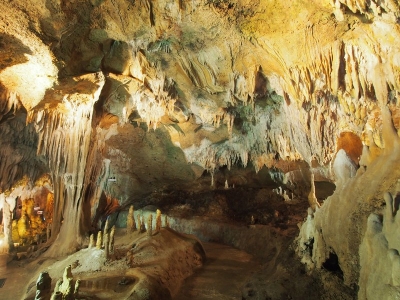
Stalactites and stalagmites can be found in limestone caves. As water drips down through limestone, it dissolves it and leaves behind deposits of a mineral called calcite. This produces distinctive stalactites that hang from the roof of the cave. When the calcite forms in pools of water on the cave floor, deposits grow upwards, forming stalagmites. Where the two features meet, they form columns.

Stalactite and stalagmite, elongated forms of various minerals deposited from solution by slowly dripping water. A stalactite hangs like an icicle from the ceiling or sides of a cavern. A stalagmite appears like an inverted stalactite, rising from the floor of a cavern.

Stalactites hanging from the ceilings of caverns commonly exhibit a central tube or the trace of a former tube whose diameter is that of a drop of water hanging by surface tension. A drop on the tip of a growing stalactite leaves a deposit only around its rim. Downward growth of the rim makes the tube. The simplest stalactite form, therefore, is a thin-walled stone straw, and these fragile forms may reach lengths of 0.5 m (20 inches) or more where air currents have not seriously disturbed the growth. The more common form is a downward-tapering cone and is simply a thickening of the straw type by mineral deposition from a film of water descending the exterior of the pendant.

Stalagmites have thicker proportions and grow up on the bottom of a cavern from the same drip-water source, the mineral from which is deposited after the water droplet falls across the open space in the rock. Not every stalactite has a complementary stalagmite, and many of the latter may have no stalactite above them. Where the paired relation exists, however, continual elongation of one or both may eventually result in a junction and the formation of a column.

The dominant mineral in such deposits is calcite (calcium carbonate), and the largest displays are formed in caves of limestone and dolomite. Other minerals that may be deposited include other carbonates, opal, chalcedony, limonite, and some sulfides.

Picture Credit : Google


HOW DO CAVES FORM?

Caves can form in different ways, depending on the type of landscape in which they are situated. Limestone is a very soft rock, and caves are quite common in limestone areas as it dissolves in rainwater. Caves can be formed out of coastal cliff faces by waves crashing against them, and ice caves may appear where streams of melt water run beneath a glacier. The hardened lava of a volcanic eruption may also leave a hollow beneath, producing a lava cave.

Caves are formed by the dissolution of limestone. Rainwater picks up carbon dioxide from the air and as it percolates through the soil, which turns into a weak acid. This slowly dissolves out the limestone along the joints, bedding planes and fractures, some of which become enlarged enough to form caves.

The largest caves form where water flows onto the limestone from the adjacent impermeable Portishead Formation (Old Red Sandstone), and Avon Group mudstones. The water sinks underground into holes known locally as ‘swallets’ or ‘slockers’. The streams reappear at the base of the limestone outcrop at large springs, for example at Cheddar and Wookey Hole. Over time, the water finds new lower routes leaving some caves high and dry. Some of these have been dug out by cavers.

The dipping Carboniferous limestones have produced a particular style of cave. A typical Mendip swallet cave is developed where a stream sinks underground at the contact between the Avon Group and the Carboniferous Limestone.

Initially the cave descends steeply, often down dip or along joints, via a series of small cascades or pitches. On reaching the water table the passage enters the phreatic, (sub water table) zone, marked by a water-filled section known as a sump. These phreatic passages display a characteristic looping profile as the water flows down a bedding plane, and then ascends up a joint or other fracture to gain higher bedding planes within the limestone en route to the resurgence. As time progresses, the cave will tend towards a more graded even profile.

Erosion at the spring outlet may cause the stream to find a new lower course, leaving the former passage high and dry. In this way a whole series of abandoned former stream courses may lie above the active streamway. For example, Gough’s Cave in Cheddar, is a former, abandoned, course of the River Yeo. Detailed studies of these passages can give clues about how the cave evolved over time and former water-table positions. These abandoned passages may become modified by breakdown and collapse, be partially infilled by sediment or stalagmite deposition, or even become reactivated or destroyed at a later date.

Picture Credit : Google